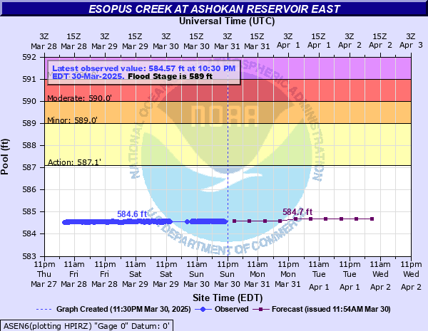
Esopus Creek at Ashokan Reservoir East
Critical Stages
587.1' - Action
589' - Flood
590' - Moderate
591' - Major
Latest Observation
Updated: 9:15 AM EST 12/6/25
Status: No Flooding
Stage: 574.1 ft
Flow: -999 kcfs
Forecast
| Time | Stage (ft) | Flow (kcfs) |
|---|---|---|
| 1 PM 12/6 | 574.2 | -999 |
| 7 PM 12/6 | 574.3 | -999 |
| 1 AM 12/7 | 574.4 | -999 |
| 7 AM 12/7 | 574.5 | -999 |
| 1 PM 12/7 | 574.6 | -999 |
| 7 PM 12/7 | 574.8 | -999 |
| 1 AM 12/8 | 574.9 | -999 |
| 7 AM 12/8 | 575 | -999 |
| Time | Stage (ft) | Flow (kcfs) |
|---|---|---|
| 9:45 AM 12/6 | 574.1 | -999 |
| 9:30 AM 12/6 | 574.1 | -999 |
| 9:15 AM 12/6 | 574.1 | -999 |
| 9:00 AM 12/6 | 574.09 | -999 |
| 8:45 AM 12/6 | 574.09 | -999 |
| 8:30 AM 12/6 | 574.07 | -999 |
| 8:15 AM 12/6 | 574.08 | -999 |
| 8:00 AM 12/6 | 574.07 | -999 |
| 7:45 AM 12/6 | 574.08 | -999 |
| 7:30 AM 12/6 | 574.07 | -999 |
| 7:15 AM 12/6 | 574.07 | -999 |
| 7:00 AM 12/6 | 574.05 | -999 |
| 6:45 AM 12/6 | 574.05 | -999 |
| 6:30 AM 12/6 | 574.04 | -999 |
| 6:15 AM 12/6 | 574.04 | -999 |
| 6:00 AM 12/6 | 574.04 | -999 |
| 5:45 AM 12/6 | 574.03 | -999 |
| 5:30 AM 12/6 | 574.03 | -999 |
| 5:15 AM 12/6 | 574.03 | -999 |
| 5:00 AM 12/6 | 574.02 | -999 |
| 4:45 AM 12/6 | 574.02 | -999 |
| 4:30 AM 12/6 | 574.02 | -999 |
| 4:15 AM 12/6 | 574.01 | -999 |
| 4:00 AM 12/6 | 574 | -999 |
| 3:45 AM 12/6 | 573.99 | -999 |
| 3:30 AM 12/6 | 573.99 | -999 |
| 3:15 AM 12/6 | 573.98 | -999 |
| 3:00 AM 12/6 | 573.98 | -999 |
| 2:45 AM 12/6 | 573.98 | -999 |
| 2:30 AM 12/6 | 573.97 | -999 |
587.1' -
Reservoir at spillway level and begins to overflow into the Esopus Creek downstream. Downstream flooding is reference to the Mount Marion gage MRNN6.
586.5' -
This basin is nearly full and only 0.25 inch runoff is needed to start spilling over into the Esopus Creek downstream.
585.79' -
This basin has capacity for only about 0.50 inch of runoff before it will overflow into the Esopus Creek downstream.
585.1' -
This basin has capacity for only about 0.75 inch of runoff. It is getting close to full.
584.4' -
This basin has capacity for only about 1.0 inch of runoff.
583.1' -
This basin has capacity for about 1.5 inches of runoff.
581.6' -
This basin has capacity for about 2.0 inches of runoff.
580.29' -
This basin has capacity for about 2.5 inches of runoff.
578.79' -
This basin has capacity for about 3.0 inches of runoff.
576' -
This basin has capacity for about 4.0 inches of runoff.
573' -
This basin has capacity for about 5.0 inches of runoff.
570' -
This basin has capacity for about 6.0 inches of runoff.
| Date | Stage (ft) |
|---|---|
| Mar 31, 1951 | 592.23 |
| Apr 3, 2005 | 591.38 |
| Apr 5, 1987 | 590.9 |
| Aug 29, 2011 | 590.58 |
| Apr 17, 2007 | 589.92 |
| Sep 8, 2011 | 589.56 |
| Nov 9, 1977 | 589.54 |
| Mar 23, 2010 | 589.39 |
| Sep 19, 2004 | 589.05 |
| May 11, 1998 | 588.84 |
| Dec 3, 1996 | 588.8 |
| Apr 18, 1993 | 588.65 |
| Apr 17, 1996 | 588.32 |
| Apr 17, 1994 | 588.12 |
| Mar 5, 1991 | 588.11 |
| May 12, 1990 | 588.03 |
| Apr 25, 1995 | 587.2 |
| Jun 12, 1992 | 586.22 |
Data provided by the National Weather Service.