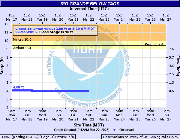
Rio Grande below Taos
Critical Stages
9' - Action
10' - Flood
12' - Moderate
15' - Major
Latest Observation
Updated: 6:30 AM MST 12/16/25
Status: No Flooding
Stage: 4.1 ft
Flow: 0.622 kcfs
Forecast
Forecast not available for this location.
| Time | Stage (ft) | Flow (kcfs) |
|---|---|---|
| 6:30 AM 12/16 | 4.1 | 0.622 |
| 6:15 AM 12/16 | 4.1 | 0.622 |
| 6:00 AM 12/16 | 4.1 | 0.622 |
| 5:45 AM 12/16 | 4.1 | 0.622 |
| 5:30 AM 12/16 | 4.1 | 0.622 |
| 5:15 AM 12/16 | 4.1 | 0.622 |
| 5:00 AM 12/16 | 4.1 | 0.622 |
| 4:45 AM 12/16 | 4.1 | 0.622 |
| 4:30 AM 12/16 | 4.11 | 0.629 |
| 4:15 AM 12/16 | 4.11 | 0.629 |
| 4:00 AM 12/16 | 4.11 | 0.629 |
| 3:45 AM 12/16 | 4.11 | 0.629 |
| 3:30 AM 12/16 | 4.11 | 0.629 |
| 3:15 AM 12/16 | 4.11 | 0.629 |
| 3:00 AM 12/16 | 4.12 | 0.635 |
| 2:45 AM 12/16 | 4.12 | 0.635 |
| 2:30 AM 12/16 | 4.12 | 0.635 |
| 2:15 AM 12/16 | 4.12 | 0.635 |
| 2:00 AM 12/16 | 4.13 | 0.642 |
| 1:45 AM 12/16 | 4.13 | 0.642 |
| 1:30 AM 12/16 | 4.13 | 0.642 |
| 1:15 AM 12/16 | 4.13 | 0.642 |
| 1:00 AM 12/16 | 4.13 | 0.642 |
| 12:45 AM 12/16 | 4.13 | 0.642 |
| 12:30 AM 12/16 | 4.13 | 0.642 |
| 12:15 AM 12/16 | 4.13 | 0.642 |
| 12:00 AM 12/16 | 4.13 | 0.642 |
| 11:45 PM 12/15 | 4.13 | 0.642 |
| 11:30 PM 12/15 | 4.13 | 0.642 |
| 11:15 PM 12/15 | 4.13 | 0.642 |
10' -
Portions of state road 570 from above Pilar up to the Taos Junction bridge are inundated by one to two feet of water. Water levels have not been this high in the Pilar region since at least 1921. Rafting takeout points below the Taos Junction bridge along state road 570 may no longer be accessable.
9' -
A few low spots along state road 570 above Pilar along the Rio Grande will have up to six inches of ponded water on the roadway. Some of the day use recreation areas above Pilar between state road 570 and the Rio Grande will begin to flood.
| Date | Stage (ft) |
|---|---|
| May 17, 1941 | 9.41 |
| Jun 22, 1949 | 9.23 |
| Jun 7, 1948 | 9.18 |
| May 19, 1987 | 8.92 |
| May 8, 1952 | 8.8 |
| May 13, 1942 | 8.75 |
| Jul 6, 1995 | 8.74 |
| Jun 14, 1985 | 8.69 |
| Jun 10, 1979 | 8.57 |
| May 27, 2005 | 8.13 |
| Jun 6, 1997 | 7.08 |
| May 24, 2008 | 6.79 |
Data provided by the National Weather Service.