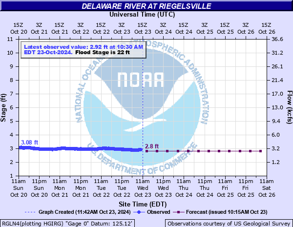
Delaware River at Riegelsville
Critical Stages
15' - Action
22' - Flood
26' - Moderate
30' - Major
Latest Observation
Updated: 12:30 PM EST 12/6/25
Status: No Flooding
Stage: 2.77 ft
Flow: 2.72 kcfs
Forecast
| Time | Stage (ft) | Flow (kcfs) |
|---|---|---|
| 7 PM 12/6 | 2.7 | 2.58 |
| 1 AM 12/7 | 2.7 | 2.58 |
| 7 AM 12/7 | 2.7 | 2.58 |
| 1 PM 12/7 | 2.6 | 2.39 |
| 7 PM 12/7 | 2.6 | 2.39 |
| 1 AM 12/8 | 2.6 | 2.39 |
| 7 AM 12/8 | 2.6 | 2.39 |
| 1 PM 12/8 | 2.6 | 2.39 |
| 7 PM 12/8 | 2.6 | 2.39 |
| 1 AM 12/9 | 2.6 | 2.39 |
| 7 AM 12/9 | 2.6 | 2.39 |
| Time | Stage (ft) | Flow (kcfs) |
|---|---|---|
| 12:30 PM 12/6 | 2.77 | 2.72 |
| 12:15 PM 12/6 | 2.77 | 2.72 |
| 12:00 PM 12/6 | 2.77 | 2.72 |
| 11:45 AM 12/6 | 2.77 | 2.72 |
| 11:30 AM 12/6 | 2.78 | 2.74 |
| 11:15 AM 12/6 | 2.77 | 2.72 |
| 11:00 AM 12/6 | 2.77 | 2.72 |
| 10:45 AM 12/6 | 2.77 | 2.72 |
| 10:30 AM 12/6 | 2.77 | 2.72 |
| 10:15 AM 12/6 | 2.78 | 2.74 |
| 10:00 AM 12/6 | 2.78 | 2.74 |
| 9:45 AM 12/6 | 2.78 | 2.74 |
| 9:30 AM 12/6 | 2.77 | 2.72 |
| 9:15 AM 12/6 | 2.77 | 2.72 |
| 9:00 AM 12/6 | 2.77 | 2.72 |
| 8:45 AM 12/6 | 2.77 | 2.72 |
| 8:30 AM 12/6 | 2.77 | 2.72 |
| 8:15 AM 12/6 | 2.77 | 2.72 |
| 8:00 AM 12/6 | 2.77 | 2.72 |
| 7:45 AM 12/6 | 2.77 | 2.72 |
| 7:30 AM 12/6 | 2.78 | 2.74 |
| 7:15 AM 12/6 | 2.78 | 2.74 |
| 7:00 AM 12/6 | 2.78 | 2.74 |
| 6:45 AM 12/6 | 2.78 | 2.74 |
| 6:30 AM 12/6 | 2.78 | 2.74 |
| 6:15 AM 12/6 | 2.79 | 2.76 |
| 6:00 AM 12/6 | 2.78 | 2.74 |
| 5:45 AM 12/6 | 2.79 | 2.76 |
| 5:30 AM 12/6 | 2.79 | 2.76 |
| 5:15 AM 12/6 | 2.79 | 2.76 |
30' -
The town of Reigelsville, Pennsylvania begins to flood.
26' -
River Road in Carpentersville is flooded and is subject to closures. Street flooding begins in Riegelsville at the intersection of PA Route 611 and Sycamore Road.
22' -
Pohatcong Creek floods Creek Road due to high and backwater from the Delaware River. The Musconetcong River also floods Mount Joy Road due to high and backwater from the Delaware River.
18' -
River Road floods in Pohatcong Township, north of the bridge.
15' -
Treasure Island Scout Camp floods.
14.5' -
The entrance to Bull Island State Park is closed. Unsafe to cross over to Treasure Island Scout Camp.
| Date | Stage (ft) |
|---|---|
| Aug 20, 1955 | 38.85 |
| Oct 10, 1903 | 35.9 |
| Apr 3, 2005 | 34.07 |
| Jun 29, 2006 | 33.62 |
| Mar 19, 1936 | 32.45 |
| Sep 19, 2004 | 30.95 |
| Jan 20, 1996 | 28.72 |
| Sep 9, 2011 | 28.06 |
| May 24, 1942 | 27.5 |
| Apr 1, 1940 | 26.47 |
| Dec 12, 1952 | 25.4 |
| Mar 12, 2011 | 25.2 |
| Mar 16, 1986 | 25.16 |
| Mar 28, 1913 | 25 |
| Sep 2, 2021 | 24.92 |
| Aug 29, 2011 | 24.51 |
| May 30, 1984 | 24.46 |
| Jun 30, 1973 | 24.36 |
| Apr 17, 1983 | 24.17 |
| Oct 16, 1955 | 23.8 |
Data provided by the National Weather Service.