Clarion River at Johnsonburg
Critical Stages
5' - Action
7' - Flood
9' - Moderate
10' - Major
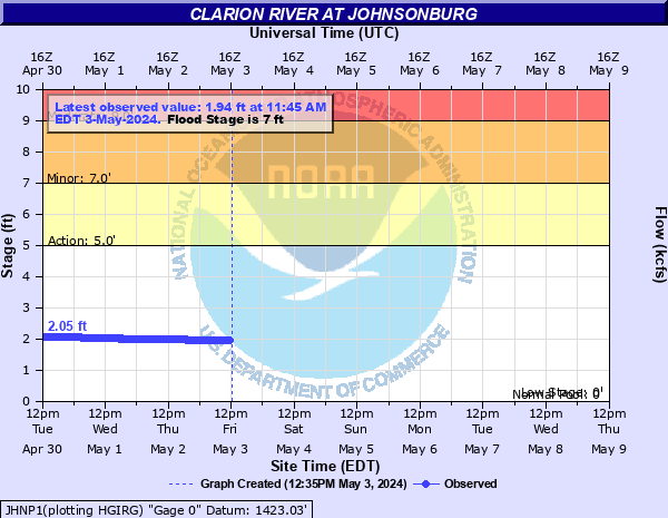
Latest Observation
Updated: 9:45 PM EST 12/16/25
Status: No Flooding
Stage: 1.73 ft
Flow: 0.125 kcfs
Forecast
Forecast not available for this location.
| Time | Stage (ft) | Flow (kcfs) |
|---|---|---|
| 9:45 PM 12/16 | 1.73 | 0.125 |
| 9:30 PM 12/16 | 1.73 | 0.125 |
| 9:15 PM 12/16 | 1.73 | 0.125 |
| 9:00 PM 12/16 | 1.73 | 0.125 |
| 8:45 PM 12/16 | 1.74 | 0.128 |
| 8:30 PM 12/16 | 1.74 | 0.128 |
| 8:15 PM 12/16 | 1.74 | 0.128 |
| 8:00 PM 12/16 | 1.73 | 0.125 |
| 7:45 PM 12/16 | 1.73 | 0.125 |
| 7:30 PM 12/16 | 1.74 | 0.128 |
| 7:15 PM 12/16 | 1.73 | 0.125 |
| 7:00 PM 12/16 | 1.74 | 0.128 |
| 6:45 PM 12/16 | 1.74 | 0.128 |
| 6:30 PM 12/16 | 1.74 | 0.128 |
| 6:15 PM 12/16 | 1.74 | 0.128 |
| 6:00 PM 12/16 | 1.74 | 0.128 |
| 5:45 PM 12/16 | 1.75 | 0.13 |
| 5:30 PM 12/16 | 1.75 | 0.13 |
| 5:15 PM 12/16 | 1.75 | 0.13 |
| 5:00 PM 12/16 | 1.75 | 0.13 |
| 4:45 PM 12/16 | 1.75 | 0.13 |
| 4:30 PM 12/16 | 1.75 | 0.13 |
| 4:15 PM 12/16 | 1.75 | 0.13 |
| 4:00 PM 12/16 | 1.77 | 0.134 |
| 3:45 PM 12/16 | 1.78 | 0.136 |
| 3:30 PM 12/16 | 1.81 | 0.143 |
| 3:15 PM 12/16 | 1.86 | 0.155 |
| 3:00 PM 12/16 | 1.89 | 0.163 |
| 2:45 PM 12/16 | 1.9 | 0.165 |
| 2:30 PM 12/16 | 1.86 | 0.155 |
10' -
A number of homes flood. Travel is restricted on Route 219.
9' -
Water level reaches Route 219. Several homes are affected by high water.
7' -
High water results in overflow of both banks.
| Date | Stage (ft) |
|---|---|
| Jul 1, 1942 | 16.7 |
| Jan 19, 1996 | 12.60000038147 |
| Jun 22, 1972 | 9.99 |
| Jun 20, 1989 | 9.86 |
| Dec 1, 2010 | 9.72 |
| May 28, 1946 | 9.2 |
| Sep 22, 1992 | 7.49 |
| Sep 18, 2004 | 7.43 |
| Sep 9, 2004 | 7.23 |
| Mar 6, 2011 | 7.12 |
| Feb 28, 2011 | 7.06 |
| Jun 21, 2019 | 7.02 |
| Nov 1, 2019 | 7 |
Data provided by the National Weather Service.