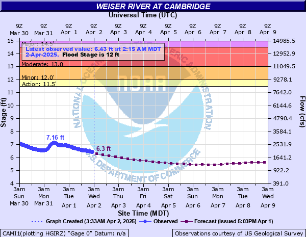
Weiser River at Cambridge
Critical Stages
11.5' - Action
12' - Flood
13' - Moderate
14.5' - Major
Latest Observation
Updated: 1:15 PM MST 12/15/25
Status: No Flooding
Stage: 3.35 ft
Flow: 0.17 kcfs
Forecast
| Time | Stage (ft) | Flow (kcfs) |
|---|---|---|
| 5 PM 12/15 | 3.37 | 0.175 |
| 11 PM 12/15 | 3.38 | 0.177 |
| 5 AM 12/16 | 3.38 | 0.177 |
| 11 AM 12/16 | 3.36 | 0.172 |
| 5 PM 12/16 | 3.35 | 0.17 |
| 11 PM 12/16 | 3.37 | 0.175 |
| 5 AM 12/17 | 3.71 | 0.271 |
| 11 AM 12/17 | 4.17 | 0.448 |
| 5 PM 12/17 | 4.12 | 0.426 |
| 11 PM 12/17 | 3.9 | 0.337 |
| 5 AM 12/18 | 3.69 | 0.265 |
| 11 AM 12/18 | 3.58 | 0.231 |
| 5 PM 12/18 | 4.11 | 0.421 |
| 11 PM 12/18 | 4.57 | 0.651 |
| 5 AM 12/19 | 4.59 | 0.663 |
| 11 AM 12/19 | 4.56 | 0.646 |
| 5 PM 12/19 | 4.49 | 0.607 |
| 11 PM 12/19 | 4.3 | 0.509 |
| 5 AM 12/20 | 4.13 | 0.43 |
| 11 AM 12/20 | 4.01 | 0.379 |
| 5 PM 12/20 | 3.97 | 0.363 |
| 11 PM 12/20 | 3.92 | 0.344 |
| 5 AM 12/21 | 3.89 | 0.333 |
| 11 AM 12/21 | 3.86 | 0.322 |
| 5 PM 12/21 | 3.93 | 0.348 |
| 11 PM 12/21 | 4.08 | 0.408 |
| 5 AM 12/22 | 4.13 | 0.43 |
| 11 AM 12/22 | 4.12 | 0.426 |
| 5 PM 12/22 | 4.14 | 0.434 |
| 11 PM 12/22 | 4.13 | 0.43 |
| 5 AM 12/23 | 4.25 | 0.485 |
| 11 AM 12/23 | 4.27 | 0.494 |
| 5 PM 12/23 | 4.22 | 0.471 |
| 11 PM 12/23 | 4.15 | 0.439 |
| 5 AM 12/24 | 4.31 | 0.514 |
| 11 AM 12/24 | 4.56 | 0.646 |
| 5 PM 12/24 | 4.68 | 0.716 |
| 11 PM 12/24 | 4.82 | 0.801 |
| 5 AM 12/25 | 5.04 | 0.94 |
| Time | Stage (ft) | Flow (kcfs) |
|---|---|---|
| 1:15 PM 12/15 | 3.35 | 0.17 |
| 1:00 PM 12/15 | 3.35 | 0.17 |
| 12:45 PM 12/15 | 3.34 | 0.167 |
| 12:30 PM 12/15 | 3.34 | 0.167 |
| 12:15 PM 12/15 | 3.34 | 0.167 |
| 12:00 PM 12/15 | 3.34 | 0.167 |
| 11:45 AM 12/15 | 3.34 | 0.167 |
| 11:30 AM 12/15 | 3.34 | 0.167 |
| 11:15 AM 12/15 | 3.34 | 0.167 |
| 11:00 AM 12/15 | 3.34 | 0.167 |
| 10:45 AM 12/15 | 3.34 | 0.167 |
| 10:30 AM 12/15 | 3.35 | 0.17 |
| 10:15 AM 12/15 | 3.35 | 0.17 |
| 10:00 AM 12/15 | 3.35 | 0.17 |
| 9:45 AM 12/15 | 3.35 | 0.17 |
| 9:30 AM 12/15 | 3.35 | 0.17 |
| 9:15 AM 12/15 | 3.34 | 0.167 |
| 9:00 AM 12/15 | 3.35 | 0.17 |
| 8:45 AM 12/15 | 3.35 | 0.17 |
| 8:30 AM 12/15 | 3.35 | 0.17 |
| 8:15 AM 12/15 | 3.35 | 0.17 |
| 8:00 AM 12/15 | 3.35 | 0.17 |
| 7:45 AM 12/15 | 3.35 | 0.17 |
| 7:30 AM 12/15 | 3.35 | 0.17 |
| 7:15 AM 12/15 | 3.35 | 0.17 |
| 7:00 AM 12/15 | 3.35 | 0.17 |
| 6:45 AM 12/15 | 3.36 | 0.172 |
| 6:30 AM 12/15 | 3.36 | 0.172 |
| 6:15 AM 12/15 | 3.36 | 0.172 |
| 6:00 AM 12/15 | 3.36 | 0.172 |
14' -
Water will impact the trailer court in Cambridge. Many county roads will be flooded and impassable. Water will flood homes near the river around Cambridge and Midvale not protected by levees.
13.5' -
Water will cover portions of Bain Road and Goodrich Road. Some homes near the river east of Cambridge will be surrounded by water and some outbuildings will be flooded. Water will approach the top of the levee protecting Mundo RV Park.
13' -
Flooding of fields and agricultural land near the river will occur from Mundo RV Park downstream through the Cambridge and Midvale areas. Water will cover portions of Old Highway Road in the canyon just south of Cambridge. Water will begin flooding feedlots near the river between the Mill Road bridge and the Highway 95 bridge east of Cambridge. Water will approach some homes between Selubia Bridge and the canyon just south of Cambridge. Debris may begin piling up at bridges.
12.5' -
Flooding of fields and agricultural land adjacent to the river can be expected around Cambridge and Midvale.
12' -
Minor flooding of low lying areas near the river can be expected downstream of Cambridge.
| Date | Stage (ft) |
|---|---|
| Dec 22, 1964 | 15.9 |
| Jan 1, 1997 | 14.54 |
| Feb 25, 1958 | 14.36 |
| Apr 9, 2019 | 14.05 |
| Jan 29, 1967 | 13.86 |
| Feb 3, 1963 | 13.51 |
| Mar 10, 2014 | 13.45 |
| Jun 5, 2010 | 13.2 |
| May 18, 1996 | 13.16 |
| Feb 29, 1972 | 12.84 |
| Feb 22, 1982 | 12.83 |
| Jan 24, 1970 | 12.67 |
| Jan 16, 1973 | 12.63 |
| Jan 17, 1974 | 12.57 |
| Dec 29, 2005 | 12.45 |
| Dec 15, 1977 | 12.11 |
| Mar 26, 1971 | 12.11 |
| Mar 14, 1983 | 11.73 |
| May 26, 1998 | 11.62 |
| Mar 9, 2017 | 11.6 |
Data provided by the National Weather Service.