South Fork Payette River at Lowman
Critical Stages
7' - Action
7.5' - Flood
8' - Moderate
9' - Major
Latest Observation
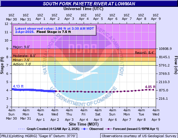
Updated: 1:30 PM MST 12/15/25
Status: No Flooding
Stage: 3.42 ft
Flow: 0.432 kcfs
Forecast
| Time | Stage (ft) | Flow (kcfs) |
|---|---|---|
| 5 PM 12/15 | 3.37 | 0.402 |
| 11 PM 12/15 | 3.37 | 0.402 |
| 5 AM 12/16 | 3.38 | 0.408 |
| 11 AM 12/16 | 3.38 | 0.408 |
| 5 PM 12/16 | 3.39 | 0.414 |
| 11 PM 12/16 | 3.39 | 0.414 |
| 5 AM 12/17 | 3.41 | 0.426 |
| 11 AM 12/17 | 3.47 | 0.463 |
| 5 PM 12/17 | 3.54 | 0.509 |
| 11 PM 12/17 | 3.57 | 0.53 |
| 5 AM 12/18 | 3.55 | 0.516 |
| 11 AM 12/18 | 3.52 | 0.496 |
| 5 PM 12/18 | 3.49 | 0.476 |
| 11 PM 12/18 | 3.49 | 0.476 |
| 5 AM 12/19 | 3.53 | 0.503 |
| 11 AM 12/19 | 3.58 | 0.537 |
| 5 PM 12/19 | 3.64 | 0.579 |
| 11 PM 12/19 | 3.7 | 0.624 |
| 5 AM 12/20 | 3.74 | 0.655 |
| 11 AM 12/20 | 3.72 | 0.639 |
| 5 PM 12/20 | 3.68 | 0.609 |
| 11 PM 12/20 | 3.62 | 0.565 |
| 5 AM 12/21 | 3.57 | 0.53 |
| 11 AM 12/21 | 3.53 | 0.503 |
| 5 PM 12/21 | 3.5 | 0.483 |
| 11 PM 12/21 | 3.48 | 0.47 |
| 5 AM 12/22 | 3.46 | 0.457 |
| 11 AM 12/22 | 3.45 | 0.451 |
| 5 PM 12/22 | 3.45 | 0.451 |
| 11 PM 12/22 | 3.46 | 0.457 |
| 5 AM 12/23 | 3.46 | 0.457 |
| 11 AM 12/23 | 3.46 | 0.457 |
| 5 PM 12/23 | 3.46 | 0.457 |
| 11 PM 12/23 | 3.46 | 0.457 |
| 5 AM 12/24 | 3.46 | 0.457 |
| 11 AM 12/24 | 3.46 | 0.457 |
| 5 PM 12/24 | 3.46 | 0.457 |
| 11 PM 12/24 | 3.46 | 0.457 |
| 5 AM 12/25 | 3.46 | 0.457 |
| Time | Stage (ft) | Flow (kcfs) |
|---|---|---|
| 1:30 PM 12/15 | 3.42 | 0.432 |
| 1:15 PM 12/15 | 3.41 | 0.426 |
| 1:00 PM 12/15 | 3.41 | 0.426 |
| 12:45 PM 12/15 | 3.41 | 0.426 |
| 12:30 PM 12/15 | 3.4 | 0.42 |
| 12:15 PM 12/15 | 3.41 | 0.426 |
| 12:00 PM 12/15 | 3.41 | 0.426 |
| 11:45 AM 12/15 | 3.41 | 0.426 |
| 11:30 AM 12/15 | 3.4 | 0.42 |
| 11:15 AM 12/15 | 3.41 | 0.426 |
| 11:00 AM 12/15 | 3.41 | 0.426 |
| 10:45 AM 12/15 | 3.41 | 0.426 |
| 10:30 AM 12/15 | 3.41 | 0.426 |
| 10:15 AM 12/15 | 3.4 | 0.42 |
| 10:00 AM 12/15 | 3.41 | 0.426 |
| 9:45 AM 12/15 | 3.4 | 0.42 |
| 9:30 AM 12/15 | 3.41 | 0.426 |
| 9:15 AM 12/15 | 3.41 | 0.426 |
| 9:00 AM 12/15 | 3.39 | 0.414 |
| 8:45 AM 12/15 | 3.41 | 0.426 |
| 8:30 AM 12/15 | 3.41 | 0.426 |
| 8:15 AM 12/15 | 3.41 | 0.426 |
| 8:00 AM 12/15 | 3.4 | 0.42 |
| 7:45 AM 12/15 | 3.41 | 0.426 |
| 7:30 AM 12/15 | 3.4 | 0.42 |
| 7:15 AM 12/15 | 3.41 | 0.426 |
| 7:00 AM 12/15 | 3.4 | 0.42 |
| 6:45 AM 12/15 | 3.4 | 0.42 |
| 6:30 AM 12/15 | 3.4 | 0.42 |
| 6:15 AM 12/15 | 3.4 | 0.42 |
9' -
The town of Lowman will experience record flooding with significant property damage.
8.5' -
Houses on both sides of the river in the lower section Lowman will flood. Sandbagging will be needed to prevent major damage. Portions of North Shore Drive, Ospree Drive and River Front Road will be flooded.
8' -
Properties downstream from the Highway 21 Bridge along North Shore Drive and along Osprey Drive on the south bank will flood. Water will reach the first floor of houses along the south bank. Flooding will occur upstream from the Highway 21 bridge along River Front Road. Rock Creek Road and Osprey Drive will be submerged in spots.
7.5' -
Water will approach houses on Osprey Drive along the south bank of the river, and sand bags will be needed to protect property. Water will begin seeping into property along North Shore Drive downstream from the Highway 21 bridge. Kirkham Hot Springs Recreational Area will be underwater.
7' -
Water will flood portions of the Kirkham Hot Springs Recreational Area and high flows will make recreation on and near the river very hazardous. The river will be filled with logs and other floating debris and bank erosion will occur near Lowman. Residents should be aware of increased river levels and prepare to protect property.
| Date | Stage (ft) |
|---|---|
| Jun 16, 1974 | 8.36 |
| Jun 5, 2010 | 8.12 |
| May 20, 2006 | 7.72 |
| Jun 1, 1986 | 7.58 |
| May 31, 2017 | 7.56 |
| Jun 11, 1972 | 7.49 |
| May 24, 1956 | 7.45 |
| Jun 20, 1982 | 7.27 |
| May 29, 1983 | 7.26 |
| May 18, 1997 | 7.22 |
| May 31, 2003 | 7.2 |
| Apr 26, 2012 | 7.16 |
| Jun 24, 2011 | 7.06 |
| May 29, 1999 | 7.05 |
| Jun 9, 1996 | 6.95 |
| May 21, 2008 | 6.9 |
| Jun 13, 2022 | 6.81 |
| May 31, 1984 | 6.68 |
| May 23, 2023 | 6.67 |
| May 28, 2014 | 6.43 |
Data provided by the National Weather Service.