Cedar River near Fullerton
Critical Stages
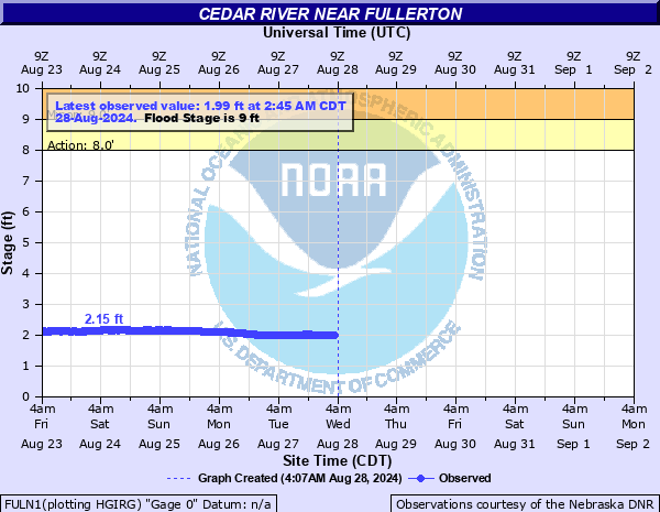
8' - Action
9' - Flood
15' - Moderate
18' - Major
Latest Observation
Updated: 4:45 PM CST 12/15/25
Status: No Flooding
Stage: 2.82 ft
Flow: 0.502 kcfs
Forecast
Forecast not available for this location.
| Time | Stage (ft) | Flow (kcfs) |
|---|---|---|
| 4:45 PM 12/15 | 2.82 | 0.502 |
| 4:30 PM 12/15 | 2.79 | 0.488 |
| 4:15 PM 12/15 | 2.77 | 0.479 |
| 4:00 PM 12/15 | 2.75 | 0.47 |
| 3:45 PM 12/15 | 2.75 | 0.47 |
| 3:30 PM 12/15 | 2.74 | 0.466 |
| 3:15 PM 12/15 | 2.73 | 0.461 |
| 3:00 PM 12/15 | 2.73 | 0.461 |
| 2:45 PM 12/15 | 2.72 | 0.457 |
| 2:30 PM 12/15 | 2.73 | 0.461 |
| 2:15 PM 12/15 | 2.72 | 0.457 |
| 2:00 PM 12/15 | 2.72 | 0.457 |
| 1:45 PM 12/15 | 2.73 | 0.461 |
| 1:30 PM 12/15 | 2.72 | 0.457 |
| 1:15 PM 12/15 | 2.73 | 0.461 |
| 1:00 PM 12/15 | 2.72 | 0.457 |
| 12:45 PM 12/15 | 2.72 | 0.457 |
| 12:30 PM 12/15 | 2.72 | 0.457 |
| 12:15 PM 12/15 | 2.73 | 0.461 |
| 12:00 PM 12/15 | 2.73 | 0.461 |
| 11:45 AM 12/15 | 3.04 | 0.604 |
| 11:30 AM 12/15 | 3.04 | 0.604 |
| 11:15 AM 12/15 | 3.04 | 0.604 |
| 11:00 AM 12/15 | 3.04 | 0.604 |
| 10:45 AM 12/15 | 3.05 | 0.609 |
| 10:30 AM 12/15 | 3.05 | 0.609 |
| 10:15 AM 12/15 | 3.06 | 0.614 |
| 10:00 AM 12/15 | 3.07 | 0.619 |
| 8:45 AM 12/15 | 3.1 | 0.635 |
| 8:30 AM 12/15 | 3.11 | 0.64 |
18' -
The Union Pacific railroad tracks which are upstream to Belgrade will flood. The north outskirts of Fullerton including Highway 14, the stock yards, and ball fields will see significant flooding. The main portion of Fullerton sits well above the flood plain and is not usually threatened.
17' -
Several feet of water will be flowing over Highway 14 just north of Fullerton on the south side of the river. In March of 2019 at a stage of 17.8 feet portions of Highway 14 north of Fullerton washed away. in addition, the stock yards and ball fields on the north side of Fullerton will be inundated by several feet of water while the bridge at the gauge site also begins to be impacted.
15' -
Highway 14 just north of Fullerton on the south side of the Cedar River will begin to flood. In addition, the ball fields and stockyard including structures in the area will begin to flood.
9' -
Water overflows the west bank of the river which is agricultural land. Water threatens two county roads, the Belgrade road and the Bottom road.
| Date | Stage (ft) |
|---|---|
| Aug 13, 1966 | 18.91 |
| Mar 13, 2019 | 17.34 |
| Mar 28, 1960 | 15.76 |
| Jul 19, 1950 | 13.65 |
| Feb 28, 1948 | 13.41 |
| Jun 25, 1969 | 13.39 |
| Feb 19, 1971 | 13.08 |
| May 26, 1964 | 12.76 |
| May 11, 1953 | 12.46 |
| Mar 26, 1962 | 12.09 |
| Mar 14, 1978 | 11.83 |
| Jul 23, 1993 | 11.43 |
| Aug 5, 1981 | 11.02 |
| Mar 25, 1952 | 10.99 |
| Jun 29, 1965 | 10.87 |
| Jun 15, 1967 | 10.87 |
| Jul 24, 1958 | 9.96 |
| Jul 21, 1958 | 9.91 |
| Aug 6, 1994 | 9.78 |
| Feb 7, 1963 | 9.48 |
Data provided by the National Weather Service.