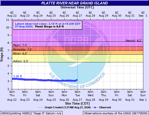
Platte River near Grand Island
Critical Stages
5.5' - Action
6.5' - Flood
7' - Moderate
7.5' - Major
Latest Observation
Updated: 4:15 PM CST 12/15/25
Status: No Flooding
Stage: 3.89 ft
Flow: 1.04 kcfs
Forecast
Forecast not available for this location.
| Time | Stage (ft) | Flow (kcfs) |
|---|---|---|
| 5:15 PM 12/15 | 3.87 | 1 |
| 5:00 PM 12/15 | 3.88 | 1.02 |
| 4:45 PM 12/15 | 3.88 | 1.02 |
| 4:30 PM 12/15 | 3.88 | 1.02 |
| 4:15 PM 12/15 | 3.89 | 1.04 |
| 4:00 PM 12/15 | 3.89 | 1.04 |
| 3:45 PM 12/15 | 3.89 | 1.04 |
| 3:30 PM 12/15 | 3.89 | 1.04 |
| 3:15 PM 12/15 | 3.88 | 1.02 |
| 3:00 PM 12/15 | 3.87 | 1 |
| 2:45 PM 12/15 | 3.87 | 1 |
| 2:30 PM 12/15 | 3.87 | 1 |
| 2:15 PM 12/15 | 3.86 | 0.984 |
| 2:00 PM 12/15 | 3.87 | 1 |
| 1:45 PM 12/15 | 3.87 | 1 |
| 1:30 PM 12/15 | 3.86 | 0.984 |
| 1:15 PM 12/15 | 3.85 | 0.964 |
| 1:00 PM 12/15 | 3.85 | 0.964 |
| 12:45 PM 12/15 | 3.83 | 0.926 |
| 12:30 PM 12/15 | 3.83 | 0.926 |
| 12:15 PM 12/15 | 3.83 | 0.926 |
| 12:00 PM 12/15 | 3.82 | 0.907 |
| 11:45 AM 12/15 | 3.81 | 0.889 |
| 11:30 AM 12/15 | 3.8 | 0.871 |
| 11:15 AM 12/15 | 3.8 | 0.871 |
| 11:00 AM 12/15 | 3.78 | 0.829 |
| 10:45 AM 12/15 | 3.78 | 0.829 |
| 10:30 AM 12/15 | 3.78 | 0.829 |
| 10:15 AM 12/15 | 3.78 | 0.829 |
| 10:00 AM 12/15 | 3.78 | 0.829 |
13' -
Water reaches the bottom of the Highway 34 bridge.
7' -
A few farmsteads west of Marquette may be threatened by overflows. The city of Grand Island is not threatened by floodwaters.
6.5' -
Farms and pasturelands flood.
6.2' -
Water approaches property at 14570 south 190th road.
5.9' -
Water ponds around the hotel by the Interstate, but water levels remain below flood stage.
| Date | Stage (ft) |
|---|---|
| Mar 27, 1960 | 8.16 |
| Mar 4, 1949 | 8.03 |
| Jun 6, 1935 | 7.99 |
| Jun 30, 1983 | 7.97 |
| Mar 4, 1940 | 7.83 |
| Jan 21, 2016 | 7.79 |
| Mar 15, 2019 | 7.78 |
| Jun 23, 1947 | 7.66 |
| Jan 9, 1974 | 7.65 |
| Mar 3, 1936 | 7.64 |
| Mar 18, 1948 | 7.62 |
| Mar 8, 1979 | 7.61 |
| Feb 28, 1938 | 7.58 |
| Mar 10, 1993 | 7.54 |
| Jun 14, 1967 | 7.52 |
| Mar 19, 1948 | 7.47 |
| Mar 17, 1978 | 7.45 |
| Jun 12, 1995 | 7.42 |
| May 17, 1973 | 7.4 |
| Jul 11, 2019 | 7.38 |
Data provided by the National Weather Service.