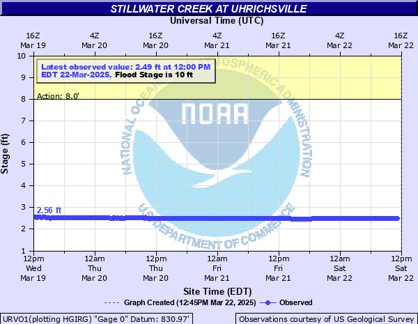
Stillwater Creek at Uhrichsville
Critical Stages
8' - Action
10' - Flood
13' - Moderate
16' - Major
Latest Observation
Updated: 11:00 PM EST 12/4/25
Status: No Flooding
Stage: 4.25 ft
Flow: 0.379 kcfs
Forecast
Forecast not available for this location.
| Time | Stage (ft) | Flow (kcfs) |
|---|---|---|
| 12:00 AM 12/5 | 4.25 | 0.379 |
| 11:45 PM 12/4 | 4.25 | 0.379 |
| 11:30 PM 12/4 | 4.25 | 0.379 |
| 11:15 PM 12/4 | 4.25 | 0.379 |
| 11:00 PM 12/4 | 4.25 | 0.379 |
| 10:45 PM 12/4 | 4.25 | 0.379 |
| 10:30 PM 12/4 | 4.25 | 0.379 |
| 10:15 PM 12/4 | 4.25 | 0.379 |
| 10:00 PM 12/4 | 4.25 | 0.379 |
| 9:45 PM 12/4 | 4.25 | 0.379 |
| 9:30 PM 12/4 | 4.25 | 0.379 |
| 9:15 PM 12/4 | 4.25 | 0.379 |
| 9:00 PM 12/4 | 4.25 | 0.379 |
| 8:45 PM 12/4 | 4.25 | 0.379 |
| 8:30 PM 12/4 | 4.26 | 0.381 |
| 8:15 PM 12/4 | 4.26 | 0.381 |
| 8:00 PM 12/4 | 4.26 | 0.381 |
| 7:45 PM 12/4 | 4.26 | 0.381 |
| 7:30 PM 12/4 | 4.26 | 0.381 |
| 7:15 PM 12/4 | 4.26 | 0.381 |
| 7:00 PM 12/4 | 4.26 | 0.381 |
| 6:45 PM 12/4 | 4.26 | 0.381 |
| 6:30 PM 12/4 | 4.26 | 0.381 |
| 6:15 PM 12/4 | 4.26 | 0.381 |
| 6:00 PM 12/4 | 4.26 | 0.381 |
| 5:45 PM 12/4 | 4.26 | 0.381 |
| 5:30 PM 12/4 | 4.26 | 0.381 |
| 5:15 PM 12/4 | 4.27 | 0.383 |
| 5:00 PM 12/4 | 4.27 | 0.383 |
| 4:45 PM 12/4 | 4.27 | 0.383 |
25.5' -
About 60 percent of Newport is under water with flood waters exntending west to Merrick Street along the west side of Stillwater Creek. Flooding also occurs in Roanoke and near First Street in Dennison . Additional flooding occurs in the south end of Dawson Street and along Thompson and Scott Street.
23.36' -
Water reaches record flood level...March 8, 1945.
17.8' -
Flooding occurs in the west and north side of Uhrichsville (Main Street, West 5th Street, the east end of 4th Street, and the east end of Franklin Street.) Also flooded are areas in Uhrichsville and Dennison along Little Stillwater Creek and the west end of Newport.
13.3' -
Flood waters reach Newport Avenue in Uhrichsville as well as East 12th Street and North Main Street half way to East 11th Street. Phac Park along Little Stillwater Creek in Dennison is flooded.
12.9' -
Numerous low land areas are flooded. Stillwater Creek begins to flood portions of Newport Street in Uhrichsville. Homes along Park Drive begin to flood. Sections of Wilson Road near Phac Park are flooded.
10' -
Stillwater Creek comes out of its banks in several locations resulting in overflowing in poor drainage areas. Minor flooding of low lying areas begins.
| Date | Stage (ft) |
|---|---|
| Mar 8, 1945 | 18.36 |
| Apr 21, 1940 | 18.17 |
| Mar 1, 1913 | 17.5 |
| Jan 8, 1950 | 17.42 |
| Apr 15, 1948 | 17.33 |
| Feb 19, 2022 | 16.26 |
| Apr 11, 1938 | 16.04 |
| Apr 4, 2024 | 15.78 |
| Dec 31, 1940 | 15.68 |
| Dec 31, 1942 | 15.43 |
| Mar 14, 1939 | 14.94 |
| Apr 11, 1942 | 14.52 |
| Mar 8, 1944 | 14.5 |
| Aug 8, 1935 | 14.2 |
| Jun 10, 1947 | 14.02 |
| Jan 26, 1949 | 14 |
| Dec 27, 1945 | 12.82 |
| Jan 26, 1937 | 12.6 |
| Mar 16, 1933 | 12 |
| Dec 16, 1927 | 11.8 |
Data provided by the National Weather Service.