St. Marys River at Rockford
Critical Stages
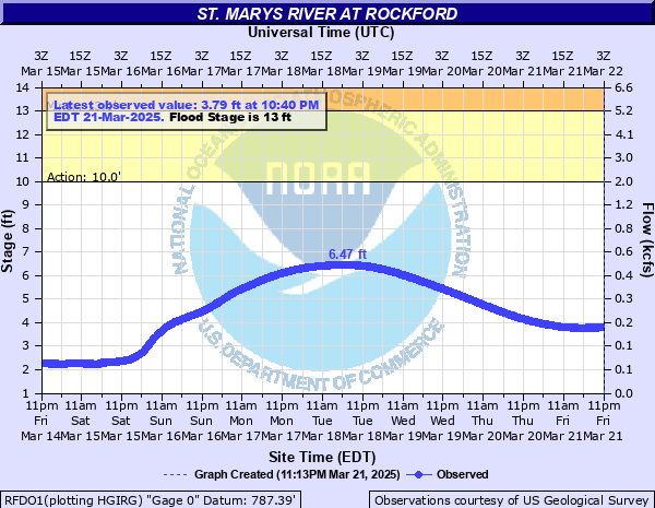
10' - Action
13' - Flood
15' - Moderate
18' - Major
Latest Observation
Updated: 11:40 PM EST 12/4/25
Status: No Flooding
Stage: 1.2 ft
Flow: 0.0284 kcfs
Forecast
Forecast not available for this location.
| Time | Stage (ft) | Flow (kcfs) |
|---|---|---|
| 11:40 PM 12/4 | 1.2 | 0.0284 |
| 11:35 PM 12/4 | 1.2 | 0.0284 |
| 11:30 PM 12/4 | 1.2 | 0.0284 |
| 11:25 PM 12/4 | 1.19 | 0.0277 |
| 11:20 PM 12/4 | 1.2 | 0.0284 |
| 11:15 PM 12/4 | 1.19 | 0.0277 |
| 11:10 PM 12/4 | 1.2 | 0.0284 |
| 11:05 PM 12/4 | 1.2 | 0.0284 |
| 11:00 PM 12/4 | 1.2 | 0.0284 |
| 10:55 PM 12/4 | 1.19 | 0.0277 |
| 10:50 PM 12/4 | 1.2 | 0.0284 |
| 10:45 PM 12/4 | 1.2 | 0.0284 |
| 10:40 PM 12/4 | 1.19 | 0.0277 |
| 10:35 PM 12/4 | 1.2 | 0.0284 |
| 10:30 PM 12/4 | 1.19 | 0.0277 |
| 10:25 PM 12/4 | 1.2 | 0.0284 |
| 10:20 PM 12/4 | 1.2 | 0.0284 |
| 10:15 PM 12/4 | 1.2 | 0.0284 |
| 10:10 PM 12/4 | 1.2 | 0.0284 |
| 10:05 PM 12/4 | 1.2 | 0.0284 |
| 10:00 PM 12/4 | 1.2 | 0.0284 |
| 9:55 PM 12/4 | 1.2 | 0.0284 |
| 9:50 PM 12/4 | 1.2 | 0.0284 |
| 9:45 PM 12/4 | 1.2 | 0.0284 |
| 9:40 PM 12/4 | 1.21 | 0.029 |
| 9:35 PM 12/4 | 1.21 | 0.029 |
| 9:30 PM 12/4 | 1.22 | 0.0296 |
| 9:25 PM 12/4 | 1.22 | 0.0296 |
| 9:20 PM 12/4 | 1.21 | 0.029 |
| 9:15 PM 12/4 | 1.22 | 0.0296 |
20' -
Water floods several homes and businesses in the north and east sides of Rockford, primarily in the area of Bridge Street, as well as near East Street and locations along Route 33 east of town. High water extends further onto Route 118 north of Rockford near Route 117 and Route 127 at the St. Marys Bridge is closed.
16' -
Water begins to flood some structures, primarily in the area of Route 33 and West Street, as well as near Route 33 and East Street on the southeast side of Rockford. In addition, Route 117 near Route 118 north of Rockford and Route 127 at the St. Marys Bridge are closed.
15' -
Water nearly floods several homes and businesses, primarily in the area of Route 33 and West Street, as well as near Route 33 and East Street on the southeast side of Rockford. In addition, Route 117 near Route 118 north of Rockford and Route 127 at the St. Marys Bridge are closed.
14.7' -
This stage is roughly the height of the FEMA 1 percent flood level. Backwater creek flooding rises onto property between West Bridge Street and North Streets.
14' -
Several roads become flooded, with Route 127 at the St. Marys bridge closed due to high water. Water extends well onto property along the river, approaching some homes and businesses. No homes are flooded at this level.
13' -
State Route 117 near Route 118 north of Rockford is water-covered and closed.
| Date | Stage (ft) |
|---|---|
| Jun 18, 2015 | 14.68 |
| Feb 8, 2008 | 14.56 |
| Mar 2, 2011 | 14.25 |
| Apr 28, 2019 | 13.32 |
| May 19, 2019 | 13.28 |
| Mar 4, 2007 | 12.41 |
| Dec 31, 2005 | 10.58 |
Data provided by the National Weather Service.