« Back to Dewey Elementary School Rivers
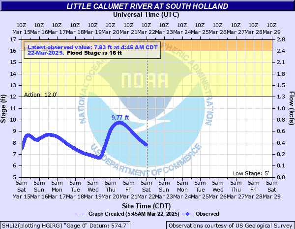
Little Calumet River at South Holland
Critical Stages
12' - Action
16' - Flood
17.5' - Moderate
19.5' - Major
Latest Observation
Updated: 7:45 AM CST 12/6/25
Status: No Flooding
Stage: 5.28 ft
Flow: 0.0455 kcfs
Forecast
Forecast not available for this location.
| Time | Stage (ft) | Flow (kcfs) |
|---|---|---|
| 7:45 AM 12/6 | 5.28 | 0.0455 |
| 7:30 AM 12/6 | 5.27 | 0.0448 |
| 7:15 AM 12/6 | 5.27 | 0.0448 |
| 7:00 AM 12/6 | 5.28 | 0.0455 |
| 6:45 AM 12/6 | 5.27 | 0.0448 |
| 6:30 AM 12/6 | 5.28 | 0.0455 |
| 6:15 AM 12/6 | 5.27 | 0.0448 |
| 6:00 AM 12/6 | 5.28 | 0.0455 |
| 5:45 AM 12/6 | 5.27 | 0.0448 |
| 5:30 AM 12/6 | 5.28 | 0.0455 |
| 5:15 AM 12/6 | 5.28 | 0.0455 |
| 5:00 AM 12/6 | 5.28 | 0.0455 |
| 4:45 AM 12/6 | 5.28 | 0.0455 |
| 4:30 AM 12/6 | 5.28 | 0.0455 |
| 4:15 AM 12/6 | 5.28 | 0.0455 |
| 4:00 AM 12/6 | 5.28 | 0.0455 |
| 3:45 AM 12/6 | 5.28 | 0.0455 |
| 3:30 AM 12/6 | 5.28 | 0.0455 |
| 3:15 AM 12/6 | 5.28 | 0.0455 |
| 3:00 AM 12/6 | 5.27 | 0.0448 |
| 2:45 AM 12/6 | 5.27 | 0.0448 |
| 2:30 AM 12/6 | 5.28 | 0.0455 |
| 2:15 AM 12/6 | 5.27 | 0.0448 |
| 2:00 AM 12/6 | 5.27 | 0.0448 |
| 1:45 AM 12/6 | 5.27 | 0.0448 |
| 1:30 AM 12/6 | 5.27 | 0.0448 |
| 1:15 AM 12/6 | 5.27 | 0.0448 |
| 1:00 AM 12/6 | 5.27 | 0.0448 |
| 12:45 AM 12/6 | 5.27 | 0.0448 |
| 12:30 AM 12/6 | 5.27 | 0.0448 |
24' -
Widespread inundation of roadways and structures in the floodplain reaches up to four blocks from the river in South Holland.
22.5' -
State Street threatened in South Holland. Sibley Boulevard (IL-83) threatened in Dolton and Harvey.
22' -
Multiple commercial structures threatened along River Oaks Drive (US-6) in Calumet City. Cottage Grove Avenue threatened in South Holland.
21.5' -
Residential structures threatened off Park Avenue in Calumet City. Multiple commercial structures threatened along Van Dam Road in South Holland.
21' -
Widespread inundation of roadways and structures in the floodplain reaches up to two blocks from the river between Gouwens Park and Veterans Park, and numerous blocks near Pioneer Park. River Oaks Drive (US-6) threatened in Calumet City. Wabash Avenue threatened in South Holland. Residential parking lots threatened off Park Avenue in Calumet City. Athletic fields threatened at Veterans Park in South Holland.
20.5' -
I-94 (Bishop Ford Freeway) threatened near US-6 in South Holland. Eisenhower Elementary threatened in South Holland. Commercial structures threatened along Greenwood Avenue in Dolton. A few residential structures threatened along Markham Drive in Harvey. A few residential structures threatened along Kenwood Avenue, Kimbark Avenue, 165th Street, and side streets in South Holland. Commercial parking lots threatened along River Oaks Drive (US-6) in Calumet City.
20' -
A few commercial structures threatened along Van Dam Road in South Holland. A few residential structures threatened along Robin Lane, Riverview Drive, 159th Place, and Blouin Drive in South Holland.
19.5' -
Residential structures threatened along South Park Avenue and 158th Street in South Holland. South Park Avenue and 158th Street threatened.
19' -
Riverview Drive, 159th Place, 158th Street, Blouin Drive, Kenwood Avenue, Kimbark Avenue, and numerous side streets threatened in South Holland. Parking lots threatened along South Park Avenue in South Holland.
18.5' -
A few structures threatened along Riverside Drive in South Holland.
18' -
Riverview Drive threatened in South Holland.
17' -
Markham Drive threatened in Harvey. Low-lying portions of Pioneer Park inundated in South Holland.
16' -
Greenwood Avenue threatened in Dolton.
15.5' -
Trails threatened at Veterans Park in South Holland. Athletic fields threatened at Gouwens Park in South Holland.
12' -
South Holland Trail threatened at Gouwens Park in South Holland. Low-lying portions of River Oaks Golf Course are inundated.
9' -
Water overtops low-lying banks in South Holland, Harvey, and Dolton.
| Date | Stage (ft) |
|---|---|
| Nov 28, 1990 | 20.5 |
| Jun 14, 1981 | 20.2 |
| Sep 14, 2008 | 20.16 |
| Jul 14, 1957 | 20.11 |
| Jul 19, 1996 | 20.01 |
| Dec 4, 1982 | 19.46 |
| Oct 11, 1954 | 19.39 |
| Apr 6, 1947 | 19.24 |
| Feb 21, 2018 | 19.23 |
| Feb 22, 1997 | 19.1 |
| Dec 31, 1972 | 18.76 |
| Dec 25, 1965 | 18.72 |
| Apr 18, 2013 | 18.59 |
| Jun 2, 1989 | 18.58 |
| May 13, 2002 | 18.37 |
| Aug 18, 1968 | 18.32 |
| May 29, 1996 | 18.07 |
| Feb 24, 1985 | 17.82 |
| Mar 5, 1979 | 17.82 |
| Jun 9, 1993 | 17.58 |
Data provided by the National Weather Service.