« Back to Dolton Public Library District Rivers
Kankakee River at Momence
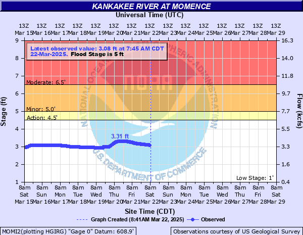
Critical Stages
4.5' - Action
5' - Flood
6.5' - Moderate
9' - Major
Latest Observation
Updated: 4:45 PM CST 12/15/25
Status: No Flooding
Stage: 3.36 ft
Flow: 3.99 kcfs
Forecast
Forecast not available for this location.
| Time | Stage (ft) | Flow (kcfs) |
|---|---|---|
| 4:45 PM 12/15 | 3.36 | 3.99 |
| 4:30 PM 12/15 | 3.39 | 4.06 |
| 4:15 PM 12/15 | 3.41 | 4.1 |
| 4:00 PM 12/15 | 3.44 | 4.17 |
| 3:45 PM 12/15 | 3.47 | 4.23 |
| 3:30 PM 12/15 | 3.51 | 4.32 |
| 3:15 PM 12/15 | 3.55 | 4.41 |
| 3:00 PM 12/15 | 3.59 | 4.5 |
| 2:45 PM 12/15 | 3.63 | 4.59 |
| 2:30 PM 12/15 | 3.67 | 4.68 |
| 2:15 PM 12/15 | 3.71 | 4.78 |
| 2:00 PM 12/15 | 3.75 | 4.87 |
| 1:45 PM 12/15 | 3.79 | 4.96 |
| 1:30 PM 12/15 | 3.82 | 5.03 |
| 1:15 PM 12/15 | 3.83 | 5.06 |
| 1:00 PM 12/15 | 3.83 | 5.06 |
| 12:45 PM 12/15 | 3.83 | 5.06 |
| 12:30 PM 12/15 | 3.83 | 5.06 |
| 12:15 PM 12/15 | 3.82 | 5.03 |
| 12:00 PM 12/15 | 3.8 | 4.99 |
| 11:45 AM 12/15 | 3.78 | 4.94 |
| 11:30 AM 12/15 | 3.74 | 4.85 |
| 11:15 AM 12/15 | 3.71 | 4.78 |
| 11:00 AM 12/15 | 3.68 | 4.71 |
| 10:45 AM 12/15 | 3.64 | 4.61 |
| 10:30 AM 12/15 | 3.61 | 4.55 |
| 10:15 AM 12/15 | 3.58 | 4.48 |
| 10:00 AM 12/15 | 3.55 | 4.41 |
| 9:45 AM 12/15 | 3.52 | 4.34 |
| 9:30 AM 12/15 | 3.47 | 4.23 |
11' -
Widespread inundation of roadways and structures up to 2 blocks from the river in Momence.
10.5' -
Numerous structures threatened north of the river, south of the river, and on Momence Island in Momence. IL-17/Dixie Highway threatened south of the river in Momence.
10' -
IL-17 threatened near the river in Sun River Terrace.
8' -
Residences threatened along Shadow Lawn Lane east of Momence.
7' -
Low-lying structures threatened north of the river in Momence. Residences threatened in the River Isle subdivision upstream of Momence. Residences threatened along Blackhawk Trail upstream of Momence. Widespread inundation of the floodplain reaches up to 2 miles from the river.
6.5' -
Residences threatneed along Serpentine Drive at Garden of Eden east of Momence. Residences threatened along Riverside Drive at Illiana east of Momence. 15500E Road and 3500N Road threatened. River North Road and River South Road threatened west of Momence.
6' -
Campgrounds threatened east of Momence.
5.5' -
Low-lying areas of Island Park inundated in Momence. River Isle Road threatened east of Momence. Eagle Island Road threatened near Sun River Terrace.
5' -
Low-lying wetlands, forest land, and agricultural land inundated along the river.
4' -
Water overtops low-lying banks at River Isle upstream from Momence.
| Date | Stage (ft) |
|---|---|
| Mar 6, 1979 | 10.51 |
| Jan 25, 1930 | 9.09 |
| Jan 4, 1919 | 8.9 |
| Jan 4, 1928 | 8.9 |
| Feb 24, 1959 | 8.82 |
| Jan 21, 1916 | 8.6 |
| Jan 30, 1965 | 8.23 |
| Feb 11, 1988 | 8.08 |
| Feb 19, 1951 | 8.06 |
| Jan 24, 1929 | 8.06 |
| Jan 3, 1974 | 7.99 |
| Feb 13, 1984 | 7.96 |
| Jan 6, 1924 | 7.9 |
| Jan 28, 1972 | 7.73 |
| Feb 25, 1936 | 7.66 |
| Dec 22, 1985 | 7.62 |
| Jan 14, 1917 | 7.6 |
| Jan 29, 1938 | 7.56 |
| Dec 18, 1951 | 7.44 |
| Feb 24, 1982 | 7.25 |
Data provided by the National Weather Service.