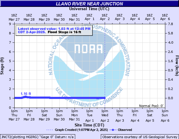
Llano River near Junction
Critical Stages
12' - Action
16' - Flood
22' - Moderate
31' - Major
Latest Observation
Updated: 1:30 AM CST 12/10/25
Status: No Flooding
Stage: 0.89 ft
Flow: 0.0577 kcfs
Forecast
Forecast not available for this location.
| Time | Stage (ft) | Flow (kcfs) |
|---|---|---|
| 2:00 AM 12/10 | 0.89 | 0.0577 |
| 1:55 AM 12/10 | 0.89 | 0.0577 |
| 1:50 AM 12/10 | 0.89 | 0.0577 |
| 1:45 AM 12/10 | 0.89 | 0.0577 |
| 1:40 AM 12/10 | 0.89 | 0.0577 |
| 1:35 AM 12/10 | 0.89 | 0.0577 |
| 1:30 AM 12/10 | 0.89 | 0.0577 |
| 1:25 AM 12/10 | 0.89 | 0.0577 |
| 1:20 AM 12/10 | 0.89 | 0.0577 |
| 1:15 AM 12/10 | 0.89 | 0.0577 |
| 1:10 AM 12/10 | 0.89 | 0.0577 |
| 1:05 AM 12/10 | 0.89 | 0.0577 |
| 1:00 AM 12/10 | 0.89 | 0.0577 |
| 12:55 AM 12/10 | 0.89 | 0.0577 |
| 12:50 AM 12/10 | 0.89 | 0.0577 |
| 12:45 AM 12/10 | 0.89 | 0.0577 |
| 12:40 AM 12/10 | 0.89 | 0.0577 |
| 12:35 AM 12/10 | 0.89 | 0.0577 |
| 12:30 AM 12/10 | 0.89 | 0.0577 |
| 12:25 AM 12/10 | 0.89 | 0.0577 |
| 12:20 AM 12/10 | 0.89 | 0.0577 |
| 12:15 AM 12/10 | 0.89 | 0.0577 |
| 12:10 AM 12/10 | 0.89 | 0.0577 |
| 12:05 AM 12/10 | 0.89 | 0.0577 |
| 12:00 AM 12/10 | 0.89 | 0.0577 |
| 11:55 PM 12/9 | 0.89 | 0.0577 |
| 11:50 PM 12/9 | 0.89 | 0.0577 |
| 11:45 PM 12/9 | 0.89 | 0.0577 |
| 11:40 PM 12/9 | 0.89 | 0.0577 |
| 11:35 PM 12/9 | 0.89 | 0.0577 |
31' -
Major flooding will occur. Numerous roads and low water crossings will be flooded and impassible. Structures along the Llano River in and near Junction will be flooded.
22' -
Moderate flooding will occur. Roads and low water crossings will be flooded and impassible.
16' -
Minor lowland flooding will occur to ranch land. Secondary roads and low water crossings will be flooded.
| Date | Stage (ft) |
|---|---|
| Jun 14, 1935 | 43.3 |
| Nov 3, 2000 | 35.08 |
| Sep 8, 1980 | 32.23 |
| Sep 16, 1936 | 32.2 |
| Oct 8, 2018 | 31.53 |
| Nov 17, 2004 | 31.47 |
| Oct 13, 1981 | 31.11 |
| Jul 22, 1938 | 30.3 |
| Dec 31, 1984 | 29.43 |
| Oct 16, 2018 | 28.39 |
| Jun 24, 1948 | 27.6 |
| Sep 1, 1932 | 27.15 |
| Oct 13, 1973 | 26.77 |
| Oct 6, 1930 | 25.2 |
| Aug 23, 1998 | 25.18 |
| Sep 17, 1990 | 24.7 |
| Oct 28, 1996 | 23.7 |
| Jul 13, 2025 | 23.56 |
| Jul 11, 1988 | 23.38 |
| Nov 15, 2001 | 22.51 |
Data provided by the National Weather Service.