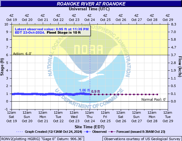
Roanoke River at Roanoke
Critical Stages
6' - Action
10' - Flood
12' - Moderate
16' - Major
Latest Observation
Updated: 2:20 AM EST 12/11/25
Status: No Flooding
Stage: 0.97 ft
Flow: 0.0887 kcfs
Forecast
| Time | Stage (ft) | Flow (kcfs) |
|---|---|---|
| 7 AM 12/11 | 1 | 0.096 |
| 1 PM 12/11 | 1 | 0.096 |
| 7 PM 12/11 | 1 | 0.096 |
| 1 AM 12/12 | 1 | 0.096 |
| 7 AM 12/12 | 1 | 0.096 |
| 1 PM 12/12 | 1 | 0.096 |
| 7 PM 12/12 | 1 | 0.096 |
| 1 AM 12/13 | 1 | 0.096 |
| 7 AM 12/13 | 1 | 0.096 |
| 1 PM 12/13 | 1 | 0.096 |
| 7 PM 12/13 | 1 | 0.096 |
| 1 AM 12/14 | 1 | 0.096 |
| 7 AM 12/14 | 1 | 0.096 |
| 1 PM 12/14 | 1 | 0.096 |
| 7 PM 12/14 | 1 | 0.096 |
| 1 AM 12/15 | 1 | 0.096 |
| 7 AM 12/15 | 1 | 0.096 |
| Time | Stage (ft) | Flow (kcfs) |
|---|---|---|
| 2:50 AM 12/11 | 0.97 | 0.0887 |
| 2:45 AM 12/11 | 0.97 | 0.0887 |
| 2:40 AM 12/11 | 0.96 | 0.0863 |
| 2:35 AM 12/11 | 0.96 | 0.0863 |
| 2:30 AM 12/11 | 0.96 | 0.0863 |
| 2:25 AM 12/11 | 0.97 | 0.0887 |
| 2:20 AM 12/11 | 0.97 | 0.0887 |
| 2:15 AM 12/11 | 0.97 | 0.0887 |
| 2:10 AM 12/11 | 0.97 | 0.0887 |
| 2:05 AM 12/11 | 0.96 | 0.0863 |
| 2:00 AM 12/11 | 0.97 | 0.0887 |
| 1:55 AM 12/11 | 0.97 | 0.0887 |
| 1:50 AM 12/11 | 0.97 | 0.0887 |
| 1:45 AM 12/11 | 0.96 | 0.0863 |
| 1:40 AM 12/11 | 0.96 | 0.0863 |
| 1:35 AM 12/11 | 0.96 | 0.0863 |
| 1:30 AM 12/11 | 0.96 | 0.0863 |
| 1:25 AM 12/11 | 0.97 | 0.0887 |
| 1:20 AM 12/11 | 0.95 | 0.084 |
| 1:15 AM 12/11 | 0.95 | 0.084 |
| 1:10 AM 12/11 | 0.96 | 0.0863 |
| 12:50 AM 12/11 | 0.96 | 0.0863 |
| 12:45 AM 12/11 | 0.96 | 0.0863 |
| 12:40 AM 12/11 | 0.96 | 0.0863 |
| 12:35 AM 12/11 | 0.96 | 0.0863 |
| 12:30 AM 12/11 | 0.95 | 0.084 |
| 12:25 AM 12/11 | 0.96 | 0.0863 |
| 12:20 AM 12/11 | 0.96 | 0.0863 |
| 12:15 AM 12/11 | 0.96 | 0.0863 |
| 12:10 AM 12/11 | 0.96 | 0.0863 |
17' -
Water reaches the bottom of the pedestrian bridge over the Roanoke River leading to the parking garage near Carilion Roanoke Memorial Hospital.
16' -
Water rises near the west entrance to Carilion Roanoke Memorial Hospital.
14' -
Jefferson Street at Belleview Avenue near Carilion Roanoke Memorial Hospital begins to flood.
11' -
Wiley Drive at the railroad underpass near Crystal Springs Avenue is flooded.
10.5' -
Flooding occurs in portions of Wasena Park.
10' -
Roanoke River Greenway path begins to flood along right bank.
3.8' -
Downstream low water bridge on Wiley Drive is flooded.
2.7' -
Upstream low water bridge on Wiley Drive is flooded.
| Date | Stage (ft) |
|---|---|
| Nov 4, 1985 | 23.35 |
| Jun 21, 1972 | 19.61 |
| Apr 27, 1978 | 18.95 |
| Aug 14, 1940 | 18.25 |
| Apr 22, 1992 | 18.09 |
| Sep 28, 2004 | 17.82 |
| Oct 11, 2018 | 16.64 |
| May 21, 2020 | 15.89 |
| Feb 23, 2003 | 15.57 |
| May 22, 1901 | 15 |
| Sep 30, 2015 | 14.62 |
| Jul 4, 2013 | 14.38 |
| Feb 16, 2025 | 14.26 |
| Nov 12, 2020 | 14.07 |
| Sep 6, 1996 | 13.9 |
| Sep 18, 1945 | 13.7 |
| Dec 4, 1948 | 13.68 |
| Apr 25, 1987 | 13.56 |
| Feb 25, 1902 | 13.2 |
| Nov 1, 1921 | 13.2 |
Data provided by the National Weather Service.