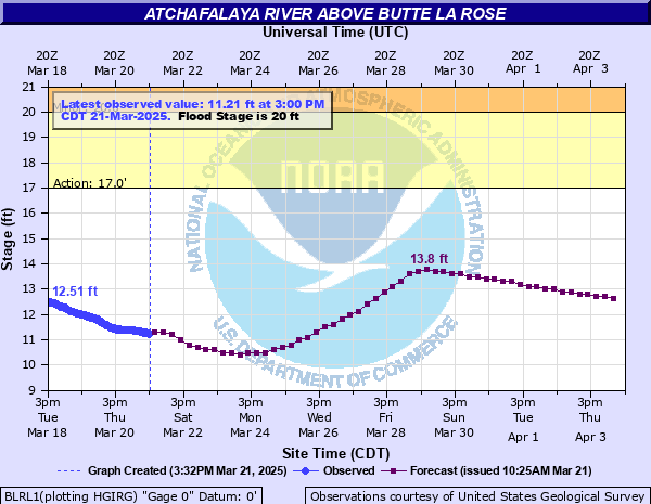
Atchafalaya River above Butte La Rose
Critical Stages
17' - Action
20' - Flood
25' - Moderate
28' - Major
Latest Observation
Updated: 1:00 PM CST 12/5/25
Status: No Flooding
Stage: 3.9 ft
Flow: 116 kcfs
Forecast
| Time | Stage (ft) | Flow (kcfs) |
|---|---|---|
| 6 PM 12/5 | 4 | 119 |
| 12 AM 12/6 | 4 | 119 |
| 6 AM 12/6 | 4 | 119 |
| 12 PM 12/6 | 3.9 | 116 |
| 6 PM 12/6 | 3.9 | 116 |
| 12 AM 12/7 | 3.9 | 116 |
| 6 AM 12/7 | 3.9 | 116 |
| 12 PM 12/7 | 3.9 | 116 |
| 6 PM 12/7 | 3.9 | 116 |
| 12 AM 12/8 | 3.9 | 116 |
| 6 AM 12/8 | 3.9 | 116 |
| 12 PM 12/8 | 3.9 | 116 |
| 6 PM 12/8 | 3.8 | 114 |
| 12 AM 12/9 | 3.8 | 114 |
| 6 AM 12/9 | 3.8 | 114 |
| 12 PM 12/9 | 3.8 | 114 |
| 6 PM 12/9 | 3.8 | 114 |
| 12 AM 12/10 | 3.8 | 114 |
| 6 AM 12/10 | 3.8 | 114 |
| 12 PM 12/10 | 3.8 | 114 |
| 6 PM 12/10 | 3.7 | 112 |
| 12 AM 12/11 | 3.7 | 112 |
| 6 AM 12/11 | 3.7 | 112 |
| 12 PM 12/11 | 3.7 | 112 |
| 6 PM 12/11 | 3.7 | 112 |
| 12 AM 12/12 | 3.6 | 109 |
| 6 AM 12/12 | 3.6 | 109 |
| 12 PM 12/12 | 3.6 | 109 |
| 6 PM 12/12 | 3.6 | 109 |
| 12 AM 12/13 | 3.6 | 109 |
| 6 AM 12/13 | 3.6 | 109 |
| 12 PM 12/13 | 3.5 | 107 |
| 6 PM 12/13 | 3.5 | 107 |
| 12 AM 12/14 | 3.5 | 107 |
| 6 AM 12/14 | 3.5 | 107 |
| 12 PM 12/14 | 3.5 | 107 |
| 6 PM 12/14 | 3.5 | 107 |
| 12 AM 12/15 | 3.4 | 105 |
| 6 AM 12/15 | 3.4 | 105 |
| 12 PM 12/15 | 3.4 | 105 |
| 6 PM 12/15 | 3.4 | 105 |
| 12 AM 12/16 | 3.4 | 105 |
| 6 AM 12/16 | 3.4 | 105 |
| 12 PM 12/16 | 3.4 | 105 |
| 6 PM 12/16 | 3.4 | 105 |
| 12 AM 12/17 | 3.4 | 105 |
| 6 AM 12/17 | 3.4 | 105 |
| 12 PM 12/17 | 3.4 | 105 |
| 6 PM 12/17 | 3.3 | 102 |
| 12 AM 12/18 | 3.3 | 102 |
| 6 AM 12/18 | 3.3 | 102 |
| 12 PM 12/18 | 3.3 | 102 |
| 6 PM 12/18 | 3.3 | 102 |
| 12 AM 12/19 | 3.3 | 102 |
| 6 AM 12/19 | 3.3 | 102 |
| Time | Stage (ft) | Flow (kcfs) |
|---|---|---|
| 1:00 PM 12/5 | 3.9 | 116 |
| 12:45 PM 12/5 | 3.91 | 117 |
| 12:30 PM 12/5 | 3.92 | 117 |
| 12:15 PM 12/5 | 3.95 | 118 |
| 12:00 PM 12/5 | 3.94 | 117 |
| 11:45 AM 12/5 | 3.97 | 118 |
| 11:30 AM 12/5 | 3.97 | 118 |
| 11:15 AM 12/5 | 3.98 | 118 |
| 11:00 AM 12/5 | 3.98 | 118 |
| 10:45 AM 12/5 | 3.99 | 119 |
| 10:30 AM 12/5 | 4 | 119 |
| 10:15 AM 12/5 | 4.02 | 119 |
| 10:00 AM 12/5 | 4.01 | 119 |
| 9:45 AM 12/5 | 4.03 | 119 |
| 9:30 AM 12/5 | 4.03 | 119 |
| 9:15 AM 12/5 | 4.04 | 120 |
| 9:00 AM 12/5 | 4.04 | 120 |
| 8:45 AM 12/5 | 4.06 | 120 |
| 8:30 AM 12/5 | 4.06 | 120 |
| 8:15 AM 12/5 | 4.07 | 120 |
| 8:00 AM 12/5 | 4.07 | 120 |
| 7:45 AM 12/5 | 4.07 | 120 |
| 7:30 AM 12/5 | 4.08 | 121 |
| 7:15 AM 12/5 | 4.1 | 121 |
| 7:00 AM 12/5 | 4.09 | 121 |
| 6:45 AM 12/5 | 4.09 | 121 |
| 6:30 AM 12/5 | 4.1 | 121 |
| 6:15 AM 12/5 | 4.11 | 121 |
| 6:00 AM 12/5 | 4.12 | 122 |
| 5:45 AM 12/5 | 4.12 | 122 |
28' -
The community of Butte La Rose will be flooded. Several homes will sustain major damage. Although the project levee height is 33 feet, back water flooding will impact the community and evacuation is strongly recommended.
27' -
Industrial operations will be curtailed. A few homes near the river will flood. River traffic negotiating sharp turns will remain difficult.
26' -
The walkway to the river gauge will be under water and the gage will be inaccessible. Industrial storage areas near the river will flood. Unsecured material and equipment on property near the river will float off or become damaged. River traffic negotiating sharp turns will become difficult.
25' -
Industrial storage areas near the river will flood. Unsecured material and equipment on property near the river will float off or become damaged. River traffic negotiating sharp turns will become difficult.
22' -
River traffic negotiating sharp turns will become difficult. Industrial equipment will be threatened and should be relocated to avoid damage.
20' -
Minor flooding begins.
17' -
Action stage.
| Date | Stage (ft) |
|---|---|
| May 23, 1973 | 27.28 |
| Mar 3, 1950 | 27 |
| Jun 2, 1961 | 26.6 |
| Jun 11, 1957 | 26.4 |
| Apr 29, 1962 | 26.4 |
| May 22, 1958 | 26.2 |
| Apr 13, 1955 | 25.9 |
| Feb 25, 1949 | 25.8 |
| Apr 28, 1945 | 25.7 |
| May 28, 1953 | 25.6 |
| Apr 16, 1952 | 25.5 |
| Apr 19, 1975 | 25.35 |
| Mar 11, 1951 | 25.3 |
| Mar 4, 1956 | 25.1 |
| Apr 7, 1963 | 24.7 |
| Apr 20, 1948 | 24.3 |
| Apr 25, 1960 | 24.2 |
| Apr 23, 1965 | 23.83 |
| Jan 30, 1946 | 23.8 |
| May 6, 1947 | 23.7 |
Data provided by the National Weather Service.