« Back to East Brunswick Vocational School Rivers
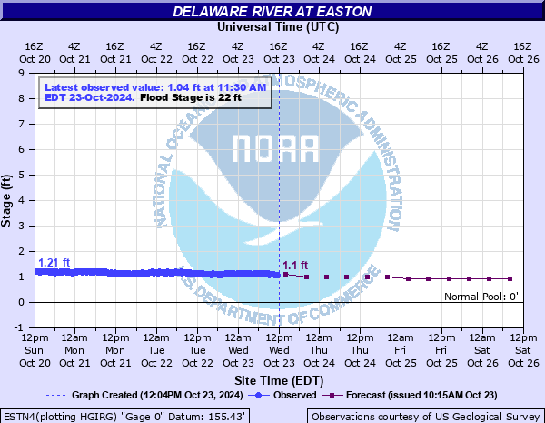
Delaware River at Easton
Critical Stages
20' - Action
22' - Flood
26' - Moderate
30' - Major
Latest Observation
Updated: 8:30 AM EST 12/6/25
Status: No Flooding
Stage: 1.17 ft
Flow: -999 kcfs
Forecast
| Time | Stage (ft) | Flow (kcfs) |
|---|---|---|
| 1 PM 12/6 | 1.1 | -999 |
| 7 PM 12/6 | 1.1 | -999 |
| 1 AM 12/7 | 1 | -999 |
| 7 AM 12/7 | 1 | -999 |
| 1 PM 12/7 | 1 | -999 |
| 7 PM 12/7 | 1 | -999 |
| 1 AM 12/8 | 0.9 | -999 |
| 7 AM 12/8 | 0.9 | -999 |
| Time | Stage (ft) | Flow (kcfs) |
|---|---|---|
| 8:30 AM 12/6 | 1.17 | -999 |
| 8:15 AM 12/6 | 1.15 | -999 |
| 8:00 AM 12/6 | 1.15 | -999 |
| 7:45 AM 12/6 | 1.17 | -999 |
| 7:30 AM 12/6 | 1.18 | -999 |
| 7:15 AM 12/6 | 1.19 | -999 |
| 7:00 AM 12/6 | 1.18 | -999 |
| 6:45 AM 12/6 | 1.18 | -999 |
| 6:30 AM 12/6 | 1.18 | -999 |
| 6:15 AM 12/6 | 1.2 | -999 |
| 6:00 AM 12/6 | 1.17 | -999 |
| 5:45 AM 12/6 | 1.19 | -999 |
| 5:30 AM 12/6 | 1.2 | -999 |
| 5:15 AM 12/6 | 1.17 | -999 |
| 5:00 AM 12/6 | 1.18 | -999 |
| 4:45 AM 12/6 | 1.16 | -999 |
| 4:30 AM 12/6 | 1.19 | -999 |
| 4:15 AM 12/6 | 1.18 | -999 |
| 4:00 AM 12/6 | 1.2 | -999 |
| 3:45 AM 12/6 | 1.2 | -999 |
| 3:30 AM 12/6 | 1.21 | -999 |
| 3:15 AM 12/6 | 1.21 | -999 |
| 3:00 AM 12/6 | 1.2 | -999 |
| 2:45 AM 12/6 | 1.19 | -999 |
| 2:30 AM 12/6 | 1.2 | -999 |
| 2:15 AM 12/6 | 1.19 | -999 |
| 2:00 AM 12/6 | 1.22 | -999 |
| 1:45 AM 12/6 | 1.22 | -999 |
| 1:30 AM 12/6 | 1.22 | -999 |
| 1:15 AM 12/6 | 1.19 | -999 |
41' -
The intersection of Third and Rose Streets in Phillipsburg begins to flood.
39' -
Union Square in Phillipsburg is flooded.
38' -
Approach roads on both sides of the Northampton Street bridge flood.
34' -
Portions of North Delaware Drive in Easton, closest to the river, begin to flood.
31' -
North Main Street at Broad Street in Phillipsburg is flooded.
28' -
Sawmill Street in Phillipsburg begins to flood due to a combination of Delaware River flooding and backwater effects from the Lopatcong Creek.
26' -
Flooding occurs in Easton up to Lehigh Drive.
25' -
Portions of Bushkill Drive and Route 611 are flooded due to a combination of Delaware River flooding and backwater effects on Bushkill Creek.
24' -
Larry Holmes Drive in Easton is subject to flooding. Riverside Way in Phillipsburg is flooded in the area of the boat ramp.
20' -
Minor flooding begins upstream in Harmony Station New Jersey and Sandts Eddy Pennsylvania.
18' -
Backwater from the Delaware causes flooding in Easton along the Lehigh River
| Date | Stage (ft) |
|---|---|
| Aug 19, 1955 | 44.4 |
| Oct 10, 1903 | 38.1 |
| Apr 4, 2005 | 37.2 |
| Jun 29, 2006 | 37.09 |
| Sep 19, 2004 | 33.45 |
| Mar 19, 1936 | 32.8 |
| Jan 20, 1996 | 30.65 |
| Sep 9, 2011 | 29.23 |
| Mar 12, 2011 | 26.11 |
| Sep 2, 2021 | 25.73 |
| Aug 29, 2011 | 25.15 |
| May 30, 1984 | 24.31 |
| Jun 30, 1973 | 24.21 |
| Oct 17, 1955 | 23.6 |
| Mar 8, 2011 | 22.88 |
| Apr 9, 2022 | 22.64 |
| Jan 28, 1996 | 22.38 |
| Dec 26, 2020 | 22.14 |
| Oct 2, 2010 | 20.72 |
| Dec 3, 1996 | 20.66 |
Data provided by the National Weather Service.