« Back to East Brunswick Vocational School Rivers
Delaware River at Trenton
Critical Stages
17' - Action
20' - Flood
23' - Moderate
25' - Major
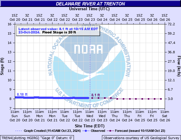
Latest Observation
Updated: 8:15 AM EST 12/6/25
Status: No Flooding
Stage: 8.16 ft
Flow: 3.46 kcfs
Forecast
| Time | Stage (ft) | Flow (kcfs) |
|---|---|---|
| 1 PM 12/6 | 8.1 | 3.27 |
| 7 PM 12/6 | 8.1 | 3.27 |
| 1 AM 12/7 | 8 | 2.96 |
| 7 AM 12/7 | 8 | 2.96 |
| 1 PM 12/7 | 8 | 2.96 |
| 7 PM 12/7 | 8 | 2.96 |
| 1 AM 12/8 | 8 | 2.96 |
| 7 AM 12/8 | 8 | 2.96 |
| Time | Stage (ft) | Flow (kcfs) |
|---|---|---|
| 8:15 AM 12/6 | 8.16 | 3.46 |
| 8:00 AM 12/6 | 8.16 | 3.46 |
| 7:45 AM 12/6 | 8.16 | 3.46 |
| 7:30 AM 12/6 | 8.16 | 3.46 |
| 7:15 AM 12/6 | 8.17 | 3.5 |
| 7:00 AM 12/6 | 8.17 | 3.5 |
| 6:45 AM 12/6 | 8.17 | 3.5 |
| 6:30 AM 12/6 | 8.17 | 3.5 |
| 6:15 AM 12/6 | 8.17 | 3.5 |
| 6:00 AM 12/6 | 8.17 | 3.5 |
| 5:45 AM 12/6 | 8.17 | 3.5 |
| 5:30 AM 12/6 | 8.17 | 3.5 |
| 5:15 AM 12/6 | 8.17 | 3.5 |
| 5:00 AM 12/6 | 8.17 | 3.5 |
| 4:45 AM 12/6 | 8.17 | 3.5 |
| 4:30 AM 12/6 | 8.18 | 3.53 |
| 4:15 AM 12/6 | 8.18 | 3.53 |
| 4:00 AM 12/6 | 8.18 | 3.53 |
| 3:45 AM 12/6 | 8.18 | 3.53 |
| 3:30 AM 12/6 | 8.17 | 3.5 |
| 3:15 AM 12/6 | 8.17 | 3.5 |
| 3:00 AM 12/6 | 8.17 | 3.5 |
| 2:45 AM 12/6 | 8.18 | 3.53 |
| 2:30 AM 12/6 | 8.18 | 3.53 |
| 2:15 AM 12/6 | 8.18 | 3.53 |
| 2:00 AM 12/6 | 8.18 | 3.53 |
| 1:45 AM 12/6 | 8.18 | 3.53 |
| 1:30 AM 12/6 | 8.18 | 3.53 |
| 1:15 AM 12/6 | 8.18 | 3.53 |
| 1:00 AM 12/6 | 8.18 | 3.53 |
25' -
The Delaware River meets the Delaware Canal, backfilling the Rivermawr and Flats neighborhoods making all roads east of the canal impassable.
24.5' -
Carr's Lane in Yardley begins to flood.
23' -
North and South Bell Avenues in Yardley begin to flood.
22' -
Route 32 in Yardley is flooded in both directions. Up to two feet of water covers portions of Morgan Avenue, Brown Street, Maple Avenue, and Fuld Avenue.
21.5' -
Ferry Street in Yardley begins to flood.
20' -
Houses on Brown Street in Yardley begin to take on water. Houses on Afton Avenue also take on water. Southbound lanes are closed along stretches of Route 29 in Trenton. Route 32 North is closed in Yardley borough. River Road (Route 32), north of Woodside Road and south of Mt. Eyre Road, in Lower Makefield Township, begins to flood.
19.5' -
Morgan Avenue in Yardley Borough begins to flood. River Road (PA Rt 32) at East Ferry Road in Lower Makefield Township begins to flood.
18.5' -
PA Route 32 South at East College Avenue in Yardley borough begins to flood. Water begins to enter Level 1 of the parking garage at the State Capital Building. Sections of Stacey Park in Trenton are closed.
18' -
PA Route 32 North is closed between Brown Street and Maple Avenue.
17' -
PA Route 32 North in Yardley Borough begins to flood between Brown Street and Maple Avenue.
| Date | Stage (ft) |
|---|---|
| Mar 8, 1904 | 30.6 |
| Aug 20, 1955 | 28.60000038147 |
| Oct 11, 1903 | 28.5 |
| Apr 4, 2005 | 25.33 |
| Jun 29, 2006 | 25.09 |
| Mar 19, 1936 | 24.43 |
| Mar 2, 1902 | 23.6 |
| Sep 19, 2004 | 23.41 |
| Jan 20, 1996 | 22.2 |
| Sep 9, 2011 | 22.16 |
| May 24, 1942 | 21.12 |
| Mar 28, 1913 | 21.1 |
| Feb 13, 1925 | 20.8 |
| Sep 3, 2021 | 20.76 |
| Jan 9, 2014 | 20.76 |
| May 30, 1984 | 20.64 |
| Apr 1, 1940 | 20.62 |
| Mar 12, 2011 | 20.59 |
| Aug 29, 2011 | 20.49 |
| Aug 25, 1933 | 20.43 |
Data provided by the National Weather Service.