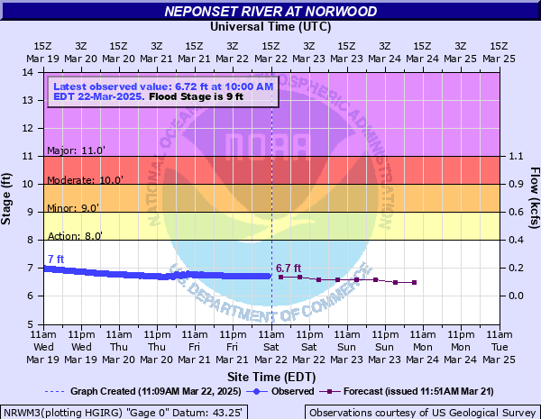
Neponset River at Norwood
Critical Stages
8' - Action
9' - Flood
10' - Moderate
11' - Major
Latest Observation
Updated: 10:00 PM EST 12/5/25
Status: No Flooding
Stage: 6.19 ft
Flow: 0.044 kcfs
Forecast
| Time | Stage (ft) | Flow (kcfs) |
|---|---|---|
| 1 AM 12/6 | 6.2 | 0.045 |
| 7 AM 12/6 | 6.2 | 0.045 |
| 1 PM 12/6 | 6.2 | 0.045 |
| 7 PM 12/6 | 6.2 | 0.045 |
| 1 AM 12/7 | 6.2 | 0.045 |
| 7 AM 12/7 | 6.2 | 0.045 |
| 1 PM 12/7 | 6.2 | 0.045 |
| 7 PM 12/7 | 6.2 | 0.045 |
| 1 AM 12/8 | 6.2 | 0.045 |
| 7 AM 12/8 | 6.2 | 0.045 |
| Time | Stage (ft) | Flow (kcfs) |
|---|---|---|
| 10:00 PM 12/5 | 6.19 | 0.044 |
| 9:45 PM 12/5 | 6.19 | 0.044 |
| 9:30 PM 12/5 | 6.19 | 0.044 |
| 9:15 PM 12/5 | 6.19 | 0.044 |
| 9:00 PM 12/5 | 6.19 | 0.044 |
| 8:45 PM 12/5 | 6.2 | 0.045 |
| 8:30 PM 12/5 | 6.2 | 0.045 |
| 8:15 PM 12/5 | 6.2 | 0.045 |
| 8:00 PM 12/5 | 6.2 | 0.045 |
| 7:45 PM 12/5 | 6.2 | 0.045 |
| 7:30 PM 12/5 | 6.2 | 0.045 |
| 7:15 PM 12/5 | 6.21 | 0.0461 |
| 7:00 PM 12/5 | 6.21 | 0.0461 |
| 6:45 PM 12/5 | 6.21 | 0.0461 |
| 6:30 PM 12/5 | 6.21 | 0.0461 |
| 6:15 PM 12/5 | 6.21 | 0.0461 |
| 6:00 PM 12/5 | 6.21 | 0.0461 |
| 5:45 PM 12/5 | 6.22 | 0.0472 |
| 5:30 PM 12/5 | 6.21 | 0.0461 |
| 5:15 PM 12/5 | 6.22 | 0.0472 |
| 5:00 PM 12/5 | 6.22 | 0.0472 |
| 4:45 PM 12/5 | 6.22 | 0.0472 |
| 4:30 PM 12/5 | 6.22 | 0.0472 |
| 4:15 PM 12/5 | 6.23 | 0.0483 |
| 4:00 PM 12/5 | 6.23 | 0.0483 |
| 3:45 PM 12/5 | 6.23 | 0.0483 |
| 3:30 PM 12/5 | 6.23 | 0.0483 |
| 3:15 PM 12/5 | 6.23 | 0.0483 |
| 3:00 PM 12/5 | 6.24 | 0.0495 |
| 2:45 PM 12/5 | 6.24 | 0.0495 |
12' -
Significant flooding is expected along the river in Walpole and Norwood. If evacuations are needed, do so immediately. Know alternate routes for travel in case your normal route becomes flooded. Norwood Memorial Airport is substantially impacted. A portion of Route 27 in Walpole near the commuter rail station is impassable. Backwater flooding occurs on Neponset Street in Canton. Floodwaters affect homes along Dean Street in Norwood near Route 1.
11.5' -
Flooding impacts homes and businesses along the river in Walpole and Norwood, including homes along the river on Dean Street in Norwood near Route 1. A portion of Route 27 in Walpole near the commuter rail station is impassable. Backwater flooding occurs on a portion of Neponset Street in Canton. Flooding also occurs at the Norwood Memorial Airport.
11' -
Flooding impacts homes and businesses along the river in Walpole and Norwood, including homes along the river on Dean Street in Norwood near Route 1. A portion of Route 27 in Walpole near the commuter rail station is impassable. Norwood Memorial Airport is substantially impacted.
10.5' -
Flood waters reach homes along the river on Dean Street in Norwood near Route 1. Flooding may also affect a portion of Route 27 in Walpole near the commuter rail station.
10' -
Minor flooding affects homes along the river on Dean Street near Route 1 in Norwood. Widespread lowland flooding can also be expected.
9' -
Minor lowland flooding occurs along the Neponset River in Norwood.
| Date | Stage (ft) |
|---|---|
| Aug 19, 1955 | 14.65 |
| Nov 5, 1955 | 11.32 |
| Mar 30, 2010 | 11.16 |
| Mar 15, 2010 | 11.07 |
| Jul 24, 1938 | 11.05 |
| May 9, 1954 | 10.9 |
| Jun 14, 1998 | 10.89 |
| Jan 27, 1958 | 10.69 |
| Mar 18, 1968 | 10.48 |
| Dec 7, 1945 | 10.38 |
| Mar 21, 1948 | 10.3 |
| Mar 7, 1959 | 10.25 |
| May 31, 1984 | 10.22 |
| Mar 30, 1953 | 10.14 |
| Mar 12, 1952 | 10.08 |
| Oct 15, 2005 | 9.96 |
| Jan 26, 1979 | 9.89 |
| Feb 8, 1941 | 9.86 |
| Apr 3, 1951 | 9.64 |
| Apr 22, 1940 | 9.55 |
Data provided by the National Weather Service.