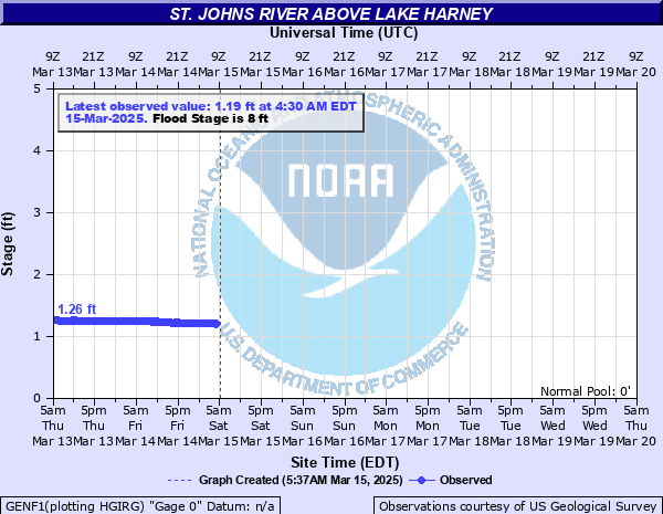
St. Johns River above Lake Harney
Critical Stages
6' - Action
8' - Flood
9' - Moderate
10' - Major
Latest Observation
Updated: 10:30 AM EST 12/6/25
Status: No Flooding
Stage: 5.42 ft
Flow: -999 kcfs
Forecast
Forecast not available for this location.
| Time | Stage (ft) | Flow (kcfs) |
|---|---|---|
| 10:30 AM 12/6 | 5.42 | -999 |
| 10:15 AM 12/6 | 5.42 | -999 |
| 10:00 AM 12/6 | 5.43 | -999 |
| 9:45 AM 12/6 | 5.42 | -999 |
| 9:30 AM 12/6 | 5.43 | -999 |
| 9:15 AM 12/6 | 5.42 | -999 |
| 9:00 AM 12/6 | 5.43 | -999 |
| 8:45 AM 12/6 | 5.43 | -999 |
| 8:30 AM 12/6 | 5.43 | -999 |
| 8:15 AM 12/6 | 5.43 | -999 |
| 8:00 AM 12/6 | 5.43 | -999 |
| 7:45 AM 12/6 | 5.43 | -999 |
| 7:30 AM 12/6 | 5.43 | -999 |
| 7:15 AM 12/6 | 5.43 | -999 |
| 7:00 AM 12/6 | 5.43 | -999 |
| 6:45 AM 12/6 | 5.44 | -999 |
| 6:30 AM 12/6 | 5.44 | -999 |
| 6:15 AM 12/6 | 5.43 | -999 |
| 6:00 AM 12/6 | 5.44 | -999 |
| 5:45 AM 12/6 | 5.45 | -999 |
| 5:30 AM 12/6 | 5.44 | -999 |
| 5:15 AM 12/6 | 5.44 | -999 |
| 5:00 AM 12/6 | 5.44 | -999 |
| 4:45 AM 12/6 | 5.45 | -999 |
| 4:30 AM 12/6 | 5.45 | -999 |
| 4:15 AM 12/6 | 5.45 | -999 |
| 4:00 AM 12/6 | 5.44 | -999 |
| 3:45 AM 12/6 | 5.45 | -999 |
| 3:30 AM 12/6 | 5.45 | -999 |
| 3:15 AM 12/6 | 5.45 | -999 |
10.8' -
Water covers State Road 46 and it may become impassable near Jungle Road and Prevatt Road. Standing water on secondary roads near the river deepens to more than three feet in some areas. Flooding becomes more significant to structures and marinas from above Lake Harney to the Lake Jesup area.
10.5' -
Water covers many secondary roads near the river, limiting access to homes to boats or high terrain vehicles. Flooding of homes along secondary roads near the river becomes more significant. Water begins to encroach on State Road 46 near Jungle Road and Prevatt Road.
10' -
Flooding of homes in low lying areas becomes more significant. Many secondary roads are impassable, limiting access to homes.
9.5' -
Water begins to move into homes in low lying areas along the river. Flooding around the Black Hammock area near Lake Jesup.
9.3' -
Many secondary roads are flooded near Lake Harney. Flooding in the Hatbill Road area near Loughman Lake.
9' -
Water enters the first story of homes on Whitcomb Drive between Crossover Lane and Lake Harney Road. Water covers Mullet Lake Park.
8.8' -
Water covers Whitcomb Road.
8.5' -
Water surrounds homes on stilts on Prevatt road, entering garages on the first story. Water fills yards and ditches along Whitcomb Drive and Lake Harney Road. Roads flood in the Palm Shores and Mullet Lake areas.
8.3' -
Docks are partially submerged along the river between Lake Harney and Lemon Bluff.
8' -
Water moves into yards on Prevatt Road off State Road 46 near Lake Harney. Flooding of boat ramps and roads occurs in Mullet Lake Park.
7.5' -
Some docks, islands and small trees along the river north of Lake Harney will be covered with water, making boating hazardous.
7' -
Water approaches boat ramps, docks in Lake Jesup Park and Mullet Lake Park.
6.5' -
Minor flooding to a few low lying areas along the river.
6' -
No Wake Zones in effect and county parks closed for areas east of Lake Monroe to Lake Harney.
| Date | Stage (ft) |
|---|---|
| Oct 3, 2022 | 12.67 |
| Aug 28, 2008 | 11.15 |
| Oct 13, 1953 | 10.62 |
| Sep 19, 2017 | 10.52 |
| Oct 15, 2024 | 10.15 |
| Oct 1, 1924 | 10.1 |
| Oct 2, 2004 | 10.08 |
| Sep 12, 2004 | 9.5 |
| Nov 21, 1994 | 9.45 |
| Nov 13, 2022 | 9.25 |
| Oct 22, 1999 | 9.21 |
| Nov 1, 2005 | 9.11 |
| Mar 1, 1998 | 8.85 |
| Jul 10, 2018 | 8.73 |
| Oct 24, 1995 | 8.71 |
| Sep 21, 2001 | 8.61 |
| Sep 30, 1994 | 8 |
| Oct 12, 1992 | 7.75 |
| Oct 11, 1991 | 7.52 |
| Jul 31, 1982 | 7.39 |
Data provided by the National Weather Service.