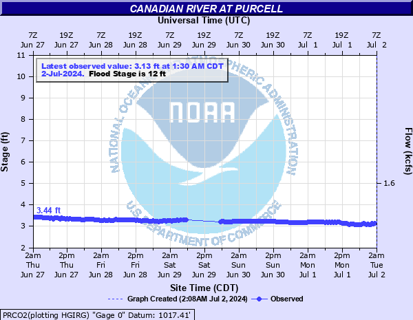
Canadian River at Purcell
Critical Stages
11' - Action
12' - Flood
13' - Moderate
14' - Major
Latest Observation
Updated: 4:30 AM CST 12/6/25
Status: No Flooding
Stage: 3.81 ft
Flow: 0.264 kcfs
Forecast
Forecast not available for this location.
| Time | Stage (ft) | Flow (kcfs) |
|---|---|---|
| 4:30 AM 12/6 | 3.81 | 0.264 |
| 4:00 AM 12/6 | 3.82 | 0.269 |
| 3:30 AM 12/6 | 3.82 | 0.269 |
| 3:00 AM 12/6 | 3.82 | 0.269 |
| 2:30 AM 12/6 | 3.82 | 0.269 |
| 2:00 AM 12/6 | 3.82 | 0.269 |
| 1:30 AM 12/6 | 3.82 | 0.269 |
| 1:00 AM 12/6 | 3.82 | 0.269 |
| 12:30 AM 12/6 | 3.82 | 0.269 |
| 12:00 AM 12/6 | 3.82 | 0.269 |
| 11:30 PM 12/5 | 3.82 | 0.269 |
| 11:00 PM 12/5 | 3.82 | 0.269 |
| 10:30 PM 12/5 | 3.82 | 0.269 |
| 10:00 PM 12/5 | 3.82 | 0.269 |
| 9:30 PM 12/5 | 3.81 | 0.264 |
| 9:00 PM 12/5 | 3.81 | 0.264 |
| 8:30 PM 12/5 | 3.82 | 0.269 |
| 8:00 PM 12/5 | 3.82 | 0.269 |
| 7:30 PM 12/5 | 3.82 | 0.269 |
| 7:00 PM 12/5 | 3.82 | 0.269 |
| 6:30 PM 12/5 | 3.82 | 0.269 |
| 6:00 PM 12/5 | 3.81 | 0.264 |
| 5:30 PM 12/5 | 3.83 | 0.273 |
| 5:00 PM 12/5 | 3.83 | 0.273 |
| 4:30 PM 12/5 | 3.83 | 0.273 |
| 4:00 PM 12/5 | 3.84 | 0.278 |
| 3:30 PM 12/5 | 3.83 | 0.273 |
| 3:00 PM 12/5 | 3.82 | 0.269 |
| 2:30 PM 12/5 | 3.85 | 0.283 |
| 2:00 PM 12/5 | 3.85 | 0.283 |
16' -
Record flooding to depths of 4 feet occurs over areas along and near the river on the Cleveland-McClain County border from near Noble... to the areas south of Purcell and Lexington.
15' -
Record fooding to depths of 3 feet occurs over areas along and near the river on the Cleveland-McClain County border from near Noble... to the areas south of of Purcell and Lexington.
14' -
Flooding to depths of 2 feet occurs over areas along and near the river on the Cleveland-McClain County border from near Noble... to areas south of of Purcell and Lexington.
13' -
Flooding to depths of a foot occurs over areas along and near the river on the Cleveland-McClain County border from near Noble... to areas south of Purcell and Lexington.
12' -
Shallow flooding of low-lying areas occurs near the river on the Cleveland-McClain County border from near Noble... to areas south of Purcell and Lexington.
11' -
Near bankfull levels occur along the river on the Cleveland-McClain County border from near Noble... to areas south of Purcell and Lexington.
10' -
The river remains within its banks along the Cleveland-McClain County border from near Noble... to areas south of Purcell and Lexington.
| Date | Stage (ft) |
|---|---|
| May 29, 1987 | 14.75 |
| May 19, 1982 | 14.5 |
| May 9, 1993 | 14.42 |
| Aug 22, 2007 | 14.12 |
| May 26, 1995 | 14 |
| Jun 10, 1995 | 13.4 |
| May 24, 2015 | 13.3 |
| May 8, 2015 | 12.45 |
| Apr 30, 2025 | 11.88 |
| Jun 5, 1995 | 11.88 |
| May 22, 2019 | 11.82 |
| May 3, 1990 | 11.58 |
| Jun 1, 2013 | 11.53 |
| Apr 10, 2008 | 11.43 |
| Jul 13, 1960 | 11.2 |
| Dec 20, 1991 | 11.13 |
| Nov 2, 1998 | 10.74 |
| Aug 3, 1996 | 10.62 |
| Mar 6, 2004 | 9.93 |
| Sep 21, 1996 | 9.21 |
Data provided by the National Weather Service.