Little Vermillion River near Salem
Critical Stages
6' - Action
7' - Flood
8' - Moderate
9' - Major
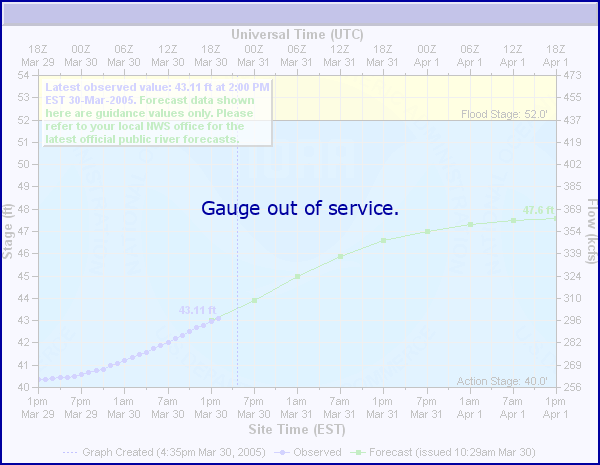
Latest Observation
Updated: 6:09 PM LMT 12/31/00
Status: Out Of Service
Stage: -999 ft
Flow: -999 kcfs
Forecast
Forecast not available for this location.
Observation history not available.
14.5' -
The bridge on Highway 81 is overtopped.
11.5' -
443rd Avenue 1 mile east of the gage is flooded.
10.5' -
The bridges on 248th Street and 444th Avenue are overtopped, and water reaches the bottom of the bridge on Highway 81.
9.5' -
The bridge on 442nd Avenue at the gage is overtopped, and the water reaches the top of the culverts on 247th Street northwest of the gage and on 443rd Avenue east of the gage.
8' -
The water reaches the bottom of the bridges on 247th Street, 248th Street, and 444th Avenue.
| Date | Stage (ft) |
|---|---|
| Jul 4, 1993 | 11.95 |
| Mar 28, 1997 | 10.01 |
| Jun 20, 1984 | 9.88 |
| Mar 14, 2010 | 9.28 |
| Mar 17, 2011 | 9.21 |
| Jun 7, 2008 | 9.17 |
| Apr 2, 2001 | 8.68 |
| Apr 5, 1969 | 8.53 |
| Mar 12, 2007 | 8.42 |
| Mar 6, 1994 | 8.38 |
| Sep 21, 1986 | 8.23 |
| Apr 20, 1995 | 7.89 |
| Mar 21, 1978 | 7.79 |
| Jun 1, 1996 | 7.73 |
| Aug 9, 1992 | 7.56 |
| Jun 13, 2005 | 7.23 |
| Mar 26, 1987 | 7.23 |
| Jun 20, 1990 | 7.23 |
| Mar 15, 1985 | 7.18 |
| Mar 5, 1970 | 6.63 |
Data provided by the National Weather Service.