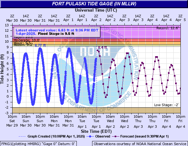
Savannah River at Fort Pulaski (IN MLLW)
Critical Stages
9.2' - Action
9.5' - Flood
10' - Moderate
10.5' - Major
Latest Observation
Updated: 3:48 AM EST 12/5/25
Status: No Flooding
Stage: 2.19 ft
Flow: -999 kcfs
Forecast
| Time | Stage (ft) | Flow (kcfs) |
|---|---|---|
| 5 AM 12/5 | 5.2 | -999 |
| 6 AM 12/5 | 7.5 | 0 |
| 7 AM 12/5 | 8.9 | 0.001 |
| 8 AM 12/5 | 9.1 | 0.002 |
| 9 AM 12/5 | 8.5 | 0.001 |
| 10 AM 12/5 | 7 | -999 |
| 11 AM 12/5 | 5 | -999 |
| 12 PM 12/5 | 2.9 | -999 |
| 1 PM 12/5 | 0.9 | -999 |
| 2 PM 12/5 | -0.3 | -999 |
| 3 PM 12/5 | -0.1 | -999 |
| 4 PM 12/5 | 1.2 | -999 |
| 5 PM 12/5 | 3.2 | -999 |
| 6 PM 12/5 | 5.2 | -999 |
| 7 PM 12/5 | 6.6 | -999 |
| 8 PM 12/5 | 7.4 | 0 |
| 9 PM 12/5 | 7.2 | 0 |
| 10 PM 12/5 | 6.2 | -999 |
| 11 PM 12/5 | 4.6 | -999 |
| 12 AM 12/6 | 2.7 | -999 |
| 1 AM 12/6 | 0.8 | -999 |
| 2 AM 12/6 | -0.5 | -999 |
| 3 AM 12/6 | -0.6 | -999 |
| 4 AM 12/6 | 0.7 | -999 |
| 5 AM 12/6 | 3 | -999 |
| 6 AM 12/6 | 5.5 | -999 |
| 7 AM 12/6 | 7.5 | 0 |
| 8 AM 12/6 | 8.8 | 0.001 |
| 9 AM 12/6 | 9 | 0.002 |
| 10 AM 12/6 | 8.3 | 0.001 |
| 11 AM 12/6 | 6.9 | -999 |
| 12 PM 12/6 | 4.9 | -999 |
| 1 PM 12/6 | 2.8 | -999 |
| 2 PM 12/6 | 0.8 | -999 |
| 3 PM 12/6 | -0.3 | -999 |
| 4 PM 12/6 | 0 | -999 |
| 5 PM 12/6 | 1.4 | -999 |
| 6 PM 12/6 | 3.3 | -999 |
| 7 PM 12/6 | 5.3 | -999 |
| 8 PM 12/6 | 6.6 | -999 |
| 9 PM 12/6 | 7.1 | 0 |
| 10 PM 12/6 | 6.9 | -999 |
| 11 PM 12/6 | 5.9 | -999 |
| 12 AM 12/7 | 4.4 | -999 |
| 1 AM 12/7 | 2.6 | -999 |
| 2 AM 12/7 | 0.8 | -999 |
| 3 AM 12/7 | -0.4 | -999 |
| 4 AM 12/7 | -0.4 | -999 |
| 5 AM 12/7 | 1 | -999 |
| 6 AM 12/7 | 3.2 | -999 |
| 7 AM 12/7 | 5.5 | -999 |
| 8 AM 12/7 | 7.5 | 0 |
| 9 AM 12/7 | 8.5 | 0.001 |
| 10 AM 12/7 | 8.7 | 0.001 |
| 11 AM 12/7 | 7.9 | 0 |
| 12 PM 12/7 | 6.5 | -999 |
| 1 PM 12/7 | 4.7 | -999 |
| 2 PM 12/7 | 2.6 | -999 |
| 3 PM 12/7 | 0.9 | -999 |
| 4 PM 12/7 | 0 | -999 |
| 5 PM 12/7 | 0.5 | -999 |
| 6 PM 12/7 | 1.9 | -999 |
| 7 PM 12/7 | 3.8 | -999 |
| 8 PM 12/7 | 5.5 | -999 |
| 9 PM 12/7 | 6.7 | -999 |
| 10 PM 12/7 | 7.1 | 0 |
| 11 PM 12/7 | 6.8 | -999 |
| 12 AM 12/8 | 5.8 | -999 |
| 1 AM 12/8 | 4.3 | -999 |
| 2 AM 12/8 | 2.5 | -999 |
| 3 AM 12/8 | 0.7 | -999 |
| 4 AM 12/8 | -0.3 | -999 |
| 5 AM 12/8 | -0.1 | -999 |
| 6 AM 12/8 | 1.4 | -999 |
| 7 AM 12/8 | 3.5 | -999 |
| 8 AM 12/8 | 5.7 | -999 |
| 9 AM 12/8 | 7.3 | 0 |
| 10 AM 12/8 | 8.3 | 0.001 |
| 11 AM 12/8 | 8.3 | 0.001 |
| 12 PM 12/8 | -9999 | -999 |
| 1 PM 12/8 | -9999 | -999 |
| Time | Stage (ft) | Flow (kcfs) |
|---|---|---|
| 3:48 AM 12/5 | 2.19 | -999 |
| 3:42 AM 12/5 | 1.7 | -999 |
| 3:36 AM 12/5 | 1.81 | -999 |
| 3:30 AM 12/5 | 1.48 | -999 |
| 3:24 AM 12/5 | 1.25 | -999 |
| 3:18 AM 12/5 | 1.01 | -999 |
| 3:12 AM 12/5 | 0.76 | -999 |
| 3:06 AM 12/5 | 0.57 | -999 |
| 3:00 AM 12/5 | 0.37 | -999 |
| 2:54 AM 12/5 | 0.2 | -999 |
| 2:48 AM 12/5 | 0.01 | -999 |
| 2:42 AM 12/5 | -0.17 | -999 |
| 2:36 AM 12/5 | -0.27 | -999 |
| 2:30 AM 12/5 | -0.38 | -999 |
| 2:24 AM 12/5 | -0.51 | -999 |
| 2:18 AM 12/5 | -0.48 | -999 |
| 2:12 AM 12/5 | -0.7 | -999 |
| 2:06 AM 12/5 | -0.79 | -999 |
| 2:00 AM 12/5 | -0.83 | -999 |
| 1:54 AM 12/5 | -0.88 | -999 |
| 1:48 AM 12/5 | -0.92 | -999 |
| 1:42 AM 12/5 | -0.9 | -999 |
| 1:36 AM 12/5 | -0.88 | -999 |
| 1:30 AM 12/5 | -0.83 | -999 |
| 1:24 AM 12/5 | -0.8 | -999 |
| 1:18 AM 12/5 | -0.74 | -999 |
| 1:12 AM 12/5 | -0.69 | -999 |
| 1:06 AM 12/5 | -0.57 | -999 |
| 1:00 AM 12/5 | -0.46 | -999 |
| 12:54 AM 12/5 | -0.37 | -999 |
12.56' -
Record tide level reached in association with Hurricane Matthew which made landfall near McClellanville, SC as a Category 1 hurricane on October 8th, 2016.
12.24' -
Peak tide level reached in association with Tropical Storm Irma on September 11th, 2017.
10.86' -
Peak tide level reached in association with an unnamed hurricane that made landfall near Ossabaw Island, GA as a Category 2 hurricane on October 15th, 1947.
10.5' -
At 10.5 ft MLLW, major coastal flooding occurs. Damaging flooding is expected, expanding along the entire southeast Georgia coast. Flooding will likely cause the closure of HW-80, isolating residents on Tybee Island. Several other island communities will also likely become isolated due to flooded and impassable roadways. On Tybee Island, widespread significant flooding is expected with numerous properties impacted.
10.4' -
Peak tide level reached in association with an unnamed hurricane that made landfall near Hilton Head Island, SC as a Category 2 hurricane on August 11th, 1940.
10.02' -
Peak tide level reached in association with Tropical Storm Gabrielle as it moved away from the Southeast coast on September 16th, 2001.
10' -
At 10.0 ft MLLW, moderate coastal flooding occurs. Shipyard Rd will be impassable, isolating residents on Burnside Island. Water will start to encroach on HW-80 and as the tide gets closer to 10.5 ft MLLW, could begin to cover portions of the roadway. Flooding will expand on Tybee Island and Catalina Dr and Lewis Ave will be impassable. Flooding will also impact Wilmington Island, the Coffee Bluff community, Ossabaw Island, Sapelo Island, and portions of HW-17 south of Darien.
9.5' -
At 9.5 ft MLLW, minor coastal flooding occurs. Flooding will begin to impact Shipyard Road to Burnside Island. Parts of Ft Pulaski National Monument will begin to flood, including several trails. Flooding will also begin to impact Tybee Island including Catalina Dr and Lewis Ave. In Bryan County, water could breach docks near Ft McAllister and flooding will impact portions of Mill Hill Rd. In Liberty County, flooding impacts the Halfmoon Landing area and Cattle Hammock Rd near Bermuda Bluff subdivision.
| Date | Stage (ft) |
|---|---|
| Oct 8, 2016 | 12.56 |
| Sep 11, 2017 | 12.235 |
| Oct 15, 1947 | 10.86 |
| Nov 7, 2021 | 10.45 |
| Oct 27, 2015 | 10.427 |
| Nov 10, 2022 | 10.41 |
| Aug 11, 1940 | 10.4 |
| Oct 10, 2025 | 10.35 |
| Feb 7, 1993 | 10.263 |
| Nov 14, 2024 | 10.25 |
| Nov 23, 2018 | 10.25 |
| Jun 4, 2023 | 10.2 |
| Nov 13, 2016 | 10.181 |
| Nov 16, 2024 | 10.17 |
| Dec 3, 1971 | 10.15 |
| Nov 8, 2021 | 10.11 |
| Jun 22, 2009 | 10.106 |
| Oct 11, 2025 | 10.09 |
| Jun 23, 2009 | 10.07 |
| Dec 17, 2023 | 10.07 |
Data provided by the National Weather Service.