Red River of the North at Fargo
Critical Stages
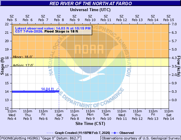
17' - Action
18' - Flood
25' - Moderate
30' - Major
Latest Observation
Updated: 10:15 AM CST 12/15/25
Status: No Flooding
Stage: 14.11 ft
Flow: 0.314 kcfs
Forecast
Forecast not available for this location.
| Time | Stage (ft) | Flow (kcfs) |
|---|---|---|
| 11:15 AM 12/15 | 14.1 | 0.309 |
| 11:00 AM 12/15 | 14.1 | 0.309 |
| 10:45 AM 12/15 | 14.12 | 0.319 |
| 10:30 AM 12/15 | 14.11 | 0.314 |
| 10:15 AM 12/15 | 14.11 | 0.314 |
| 10:00 AM 12/15 | 14.09 | 0.304 |
| 9:45 AM 12/15 | 14.11 | 0.314 |
| 9:30 AM 12/15 | 14.11 | 0.314 |
| 9:15 AM 12/15 | 14.12 | 0.319 |
| 9:00 AM 12/15 | 14.11 | 0.314 |
| 8:45 AM 12/15 | 14.13 | 0.324 |
| 8:30 AM 12/15 | 14.11 | 0.314 |
| 8:15 AM 12/15 | 14.11 | 0.314 |
| 8:00 AM 12/15 | 14.12 | 0.319 |
| 7:45 AM 12/15 | 14.12 | 0.319 |
| 7:30 AM 12/15 | 14.11 | 0.314 |
| 7:15 AM 12/15 | 14.11 | 0.314 |
| 7:00 AM 12/15 | 14.13 | 0.324 |
| 6:45 AM 12/15 | 14.1 | 0.309 |
| 6:30 AM 12/15 | 14.11 | 0.314 |
| 6:15 AM 12/15 | 14.13 | 0.324 |
| 6:00 AM 12/15 | 14.11 | 0.314 |
| 5:45 AM 12/15 | 14.14 | 0.329 |
| 5:30 AM 12/15 | 14.11 | 0.314 |
| 5:15 AM 12/15 | 14.13 | 0.324 |
| 5:00 AM 12/15 | 14.13 | 0.324 |
| 4:45 AM 12/15 | 14.11 | 0.314 |
| 4:30 AM 12/15 | 14.12 | 0.319 |
| 4:15 AM 12/15 | 14.12 | 0.319 |
| 4:00 AM 12/15 | 14.12 | 0.319 |
40.84' -
RECORD FLOOD. March 28, 2009 (instantaneous measurement).
40' -
25th Street S bridge over Rose Coulee closes (Fargo).
39' -
36th Street S bridge and 40th Avenue S bridge over Drain 27 close (Fargo).
38.5' -
11th Street N is closed near 28th Avenue N (Moorhead).
38' -
28th Avenue North is closed at Ditch #41 (Moorhead).
37.5' -
Oakport Street N is closed near 50th Avenue N (Moorhead).
37' -
Convent Bridge at 52nd Ave S is closed (Fargo).
36' -
Placing of sandbags starts if the river is forecast to rise above 38 ft (Fargo).
34' -
Northern Pacific Ave (Fargo)/Center Ave (Moorhead) bridge clearance.
33' -
Wall Street Avenue N is closed (Moorhead).
32' -
Removable floodwalls installed along 2nd Street (Fargo). 1st Avenue N bridge across Red River closed.
31' -
1st Avenue N underpass is closed (Moorhead).
30' -
MAJOR FLOOD.
28' -
Rivershore Drive underpass at I-94 is closed (Moorhead). 12th Avenue N/15th Avenue N bridge over Red River is closed (Fargo/Moorhead).
25' -
MODERATE FLOOD. City parks and recreation areas along the river begin to flood (Fargo). All storm sewer lift stations are in operation (Fargo).
21' -
3rd Street underpass is closed (Moorhead).
19' -
Low-level dam south of Main Ave is closed (Fargo).
18' -
MINOR FLOOD. Elm St between 14th and 15th Ave N is closed (Fargo). Storm sewer pump stations are beginning to operate (Fargo).
17' -
ACTION STAGE/FORECAST SERVICE STAGE. Water rises to the edge of the bike path at El Zagal bowl along Elm St N between 14th and 15th Ave (Fargo).
| Date | Stage (ft) |
|---|---|
| Mar 28, 2009 | 40.84 |
| Apr 18, 1997 | 39.72 |
| Apr 7, 1897 | 39.1 |
| Apr 9, 2011 | 38.81 |
| Apr 15, 1969 | 37.34 |
| Apr 5, 2006 | 37.13 |
| Mar 21, 2010 | 36.99 |
| Apr 14, 2001 | 36.69 |
| Apr 9, 1989 | 35.39 |
| Apr 8, 2019 | 35.04 |
| Apr 19, 1979 | 34.93 |
| Apr 2, 1978 | 34.41 |
| May 1, 2013 | 33.31 |
| Jul 4, 1975 | 33.26 |
| Jun 9, 2007 | 30.88 |
| Apr 15, 1965 | 30.5 |
| Mar 22, 1966 | 30.16 |
| Mar 31, 1907 | 29.8 |
| Apr 22, 2023 | 29.75 |
| Apr 16, 1952 | 28.79 |
Data provided by the National Weather Service.