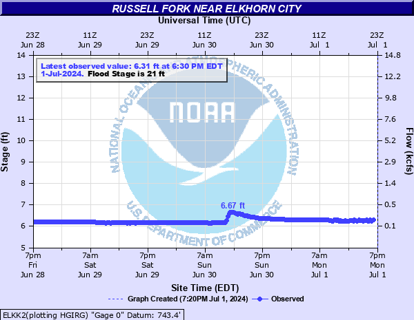
Russell Fork near Elkhorn City
Critical Stages
17' - Action
21' - Flood
22' - Moderate
24' - Major
Latest Observation
Updated: 9:30 PM EST 12/14/25
Status: No Flooding
Stage: 7.07 ft
Flow: 0.518 kcfs
Forecast
Forecast not available for this location.
| Time | Stage (ft) | Flow (kcfs) |
|---|---|---|
| 9:30 PM 12/14 | 7.07 | 0.518 |
| 9:15 PM 12/14 | 7.07 | 0.518 |
| 9:00 PM 12/14 | 7.07 | 0.518 |
| 8:45 PM 12/14 | 7.07 | 0.518 |
| 8:30 PM 12/14 | 7.07 | 0.518 |
| 8:15 PM 12/14 | 7.07 | 0.518 |
| 8:00 PM 12/14 | 7.08 | 0.525 |
| 7:45 PM 12/14 | 7.04 | 0.499 |
| 5:30 PM 12/14 | 7.02 | 0.487 |
| 5:15 PM 12/14 | 7.03 | 0.493 |
| 5:00 PM 12/14 | 7 | 0.475 |
| 4:45 PM 12/14 | 6.99 | 0.469 |
| 4:30 PM 12/14 | 7.02 | 0.487 |
| 4:15 PM 12/14 | 7 | 0.475 |
| 4:00 PM 12/14 | 6.99 | 0.469 |
| 3:45 PM 12/14 | 7.04 | 0.499 |
| 3:30 PM 12/14 | 7 | 0.475 |
| 3:15 PM 12/14 | 7 | 0.475 |
| 3:00 PM 12/14 | 7 | 0.475 |
| 2:45 PM 12/14 | 7 | 0.475 |
| 2:30 PM 12/14 | 6.99 | 0.469 |
| 2:15 PM 12/14 | 7 | 0.475 |
| 2:00 PM 12/14 | 7.01 | 0.481 |
| 1:45 PM 12/14 | 7 | 0.475 |
| 1:30 PM 12/14 | 7.01 | 0.481 |
| 1:15 PM 12/14 | 6.99 | 0.469 |
| 1:00 PM 12/14 | 7 | 0.475 |
| 12:45 PM 12/14 | 7 | 0.475 |
| 12:30 PM 12/14 | 6.97 | 0.456 |
| 12:15 PM 12/14 | 7 | 0.475 |
24.8' -
Flooding equals the highest flood on record.
24' -
Major flooding occurs. Many houses and businesses along Elkhorn Creek and Russell Fork are flooded. Several bridges are underwater.
22' -
Moderate flooding occurs. Water begins to enter houses along East Russell Street.
21' -
Low lying areas flood. Russell Fork is 400 feet wide.
| Date | Stage (ft) |
|---|---|
| Apr 4, 1977 | 24.8 |
| Jan 29, 1957 | 24.21 |
| Mar 12, 1963 | 21.73 |
| May 7, 1984 | 20.49 |
| Feb 1, 1962 | 19.2 |
| Mar 5, 2015 | 18.72 |
| Mar 7, 1967 | 18.59 |
| Feb 16, 2003 | 17.92 |
| Jan 26, 1978 | 17.84 |
| Jul 31, 1961 | 17.2 |
| May 8, 1958 | 17 |
| Mar 16, 1973 | 15.91 |
Data provided by the National Weather Service.