« Back to Estcourt Station Rivers
Allagash River above Allagash
Critical Stages
13' - Action
15' - Flood
17' - Moderate
19' - Major
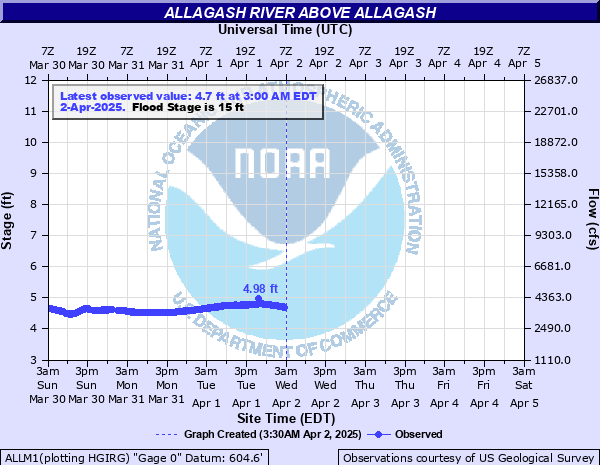
Latest Observation
Updated: 4:00 PM EST 12/16/25
Status: No Flooding
Stage: 4.01 ft
Flow: 2.51 kcfs
Forecast
Forecast not available for this location.
| Time | Stage (ft) | Flow (kcfs) |
|---|---|---|
| 4:00 PM 12/16 | 4.01 | 2.51 |
| 3:45 PM 12/16 | 4.02 | 2.52 |
| 3:30 PM 12/16 | 4.03 | 2.54 |
| 3:15 PM 12/16 | 4.03 | 2.54 |
| 3:00 PM 12/16 | 4.03 | 2.54 |
| 2:45 PM 12/16 | 4.03 | 2.54 |
| 2:30 PM 12/16 | 4.03 | 2.54 |
| 2:15 PM 12/16 | 4.02 | 2.52 |
| 12:00 PM 12/16 | 3.98 | 2.46 |
| 11:45 AM 12/16 | 3.98 | 2.46 |
| 11:30 AM 12/16 | 3.98 | 2.46 |
| 11:15 AM 12/16 | 3.98 | 2.46 |
| 11:00 AM 12/16 | 3.99 | 2.47 |
| 10:45 AM 12/16 | 3.99 | 2.47 |
| 10:30 AM 12/16 | 4 | 2.49 |
| 10:15 AM 12/16 | 4 | 2.49 |
| 10:00 AM 12/16 | 4 | 2.49 |
| 9:45 AM 12/16 | 4.01 | 2.51 |
| 9:30 AM 12/16 | 4.01 | 2.51 |
| 9:15 AM 12/16 | 4.01 | 2.51 |
| 9:00 AM 12/16 | 4.01 | 2.51 |
| 8:45 AM 12/16 | 4.02 | 2.52 |
| 8:30 AM 12/16 | 4.02 | 2.52 |
| 8:15 AM 12/16 | 4.02 | 2.52 |
| 8:00 AM 12/16 | 4.02 | 2.52 |
| 7:45 AM 12/16 | 4.02 | 2.52 |
| 7:30 AM 12/16 | 4.01 | 2.51 |
| 7:15 AM 12/16 | 4.01 | 2.51 |
| 7:00 AM 12/16 | 4.01 | 2.51 |
| 6:45 AM 12/16 | 4.01 | 2.51 |
19' -
Widespread significant flooding upstream of Eliza Hole Rapids. Michaud Tote Road and Inn Road impassable. Numerous camp roads flooded. River side campsites between Allagash Falls and Eliza Hole Rapids completely inundated. Flooding similar to April 1983 and 1991.
17' -
Significant flooding of Michaud Tote Road and Inn Road in the town of Allagash. Floodwaters threaten Route 161 in the town of Allagash combined with St. John River conditions. Campsites inundated between Allagash Falls and Eliza Hole Rapids.
15' -
Minor low lying flooding occurs between Allagash Falls and the town of Allagash. River campsites flooded between McGargle Rocks to Eliza Hole Rapids.
13' -
River approaches bankfull. River begins to threaten low lying campsites between Allagash Falls and Eliza Hole Rapids.
| Date | Stage (ft) |
|---|---|
| Apr 10, 1991 | 19.78 |
| Apr 18, 1983 | 19.48 |
| Apr 6, 1988 | 17.55 |
| Apr 30, 2008 | 14.89 |
| Apr 3, 1975 | 14.43 |
| Apr 22, 1933 | 14.22 |
| Apr 23, 1960 | 14.16 |
| Apr 26, 1970 | 13.83 |
| Apr 24, 2007 | 13.18 |
| May 1, 1939 | 13.14 |
| Apr 16, 1994 | 12.98 |
| Apr 5, 1981 | 12.76 |
| Apr 25, 1978 | 12.63 |
| Apr 17, 1984 | 12.37 |
| Apr 29, 1973 | 12.33 |
| Mar 31, 1953 | 12.28 |
| May 17, 1961 | 12.21 |
| Apr 23, 2019 | 11.91 |
| Apr 28, 2018 | 11.84 |
| May 5, 2011 | 11.1 |
Data provided by the National Weather Service.