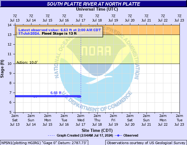
South Platte River at North Platte
Critical Stages
10' - Action
13' - Flood
14' - Moderate
15' - Major
Latest Observation
Updated: 4:00 AM CST 12/16/25
Status: No Flooding
Stage: 6.87 ft
Flow: 0.593 kcfs
Forecast
Forecast not available for this location.
| Time | Stage (ft) | Flow (kcfs) |
|---|---|---|
| 4:00 AM 12/16 | 6.87 | 0.593 |
| 3:45 AM 12/16 | 6.87 | 0.593 |
| 3:30 AM 12/16 | 6.87 | 0.593 |
| 3:15 AM 12/16 | 6.87 | 0.593 |
| 3:00 AM 12/16 | 6.87 | 0.593 |
| 2:45 AM 12/16 | 6.87 | 0.593 |
| 2:30 AM 12/16 | 6.87 | 0.593 |
| 2:15 AM 12/16 | 6.87 | 0.593 |
| 2:00 AM 12/16 | 6.87 | 0.593 |
| 1:45 AM 12/16 | 6.86 | 0.586 |
| 1:30 AM 12/16 | 6.87 | 0.593 |
| 1:15 AM 12/16 | 6.86 | 0.586 |
| 1:00 AM 12/16 | 6.86 | 0.586 |
| 12:45 AM 12/16 | 6.87 | 0.593 |
| 12:30 AM 12/16 | 6.86 | 0.586 |
| 12:15 AM 12/16 | 6.86 | 0.586 |
| 12:00 AM 12/16 | 6.86 | 0.586 |
| 11:45 PM 12/15 | 6.86 | 0.586 |
| 11:30 PM 12/15 | 6.86 | 0.586 |
| 11:15 PM 12/15 | 6.86 | 0.586 |
| 11:00 PM 12/15 | 6.86 | 0.586 |
| 10:45 PM 12/15 | 6.86 | 0.586 |
| 10:30 PM 12/15 | 6.86 | 0.586 |
| 10:15 PM 12/15 | 6.86 | 0.586 |
| 10:00 PM 12/15 | 6.86 | 0.586 |
| 9:45 PM 12/15 | 6.86 | 0.586 |
| 9:30 PM 12/15 | 6.86 | 0.586 |
| 9:15 PM 12/15 | 6.86 | 0.586 |
| 9:00 PM 12/15 | 6.86 | 0.586 |
| 8:45 PM 12/15 | 6.86 | 0.586 |
18.5' -
Low steel of the Highway 83 bridge.
18.3' -
Water may begin to enter the Sonic parking lot.
17' -
Water may reach the Quality Inn and Pizza Hut parking lots.
15' -
Major flood stage. Flooding of homes is possible along the South Platte River in and around the City of North Platte. Water is likely to back up into storm drains throughout the city of North Platte.
14' -
Moderate flood stage. Flooding of yards and basements may occur along the South Platte River. Water may flow over Buffalo Bill Road just north of the South Platte River Bridge. Water may continue to back up in storm drains in the City of North Platte.
13.5' -
Water may begin to flow over Buffalo Bill Road just north of the South Platte River bridge.
13' -
Flood Stage. Flooding of yards and roads may occur around Hidden Lakes. Most of Iron Eagle Golf Course becomes submerged. Backwash may occur into sewer and storm drains in city of North Platte.
12.8' -
Backwash may occur into sewer and storm drains in city of North Platte.
12' -
Flooding occurs on the north and east end of Iron Eagle Golf Course along the bank of the South Platte River.
10' -
Ponding of water and flooding of low lying areas at Iron Eagle Golf Course.
| Date | Stage (ft) |
|---|---|
| Sep 23, 2013 | 14.54 |
| May 20, 2015 | 14.09 |
| Jun 3, 1935 | 14.02 |
| Jun 7, 1995 | 12.99 |
| May 7, 1942 | 12.72 |
| May 13, 1973 | 12.64 |
| Jan 11, 1998 | 12.43 |
| May 8, 1999 | 12.34 |
| Mar 16, 1939 | 12.11 |
| Sep 13, 1938 | 11.95 |
| Jun 10, 1928 | 11.87 |
| Jun 30, 1947 | 11.75 |
| Jun 24, 2010 | 11.52 |
| Jun 21, 1949 | 11.48 |
| May 22, 1980 | 11.43 |
| Jun 20, 1997 | 11.33 |
| Apr 29, 1929 | 11.07 |
| Jun 12, 2014 | 11.06 |
| May 12, 1930 | 11.02 |
| Apr 4, 1931 | 10.82 |
Data provided by the National Weather Service.