« Back to Evening Shade Rivers
Baron Fork at Eldon
Critical Stages
18' - Action
18' - Flood
20' - Moderate
25' - Major
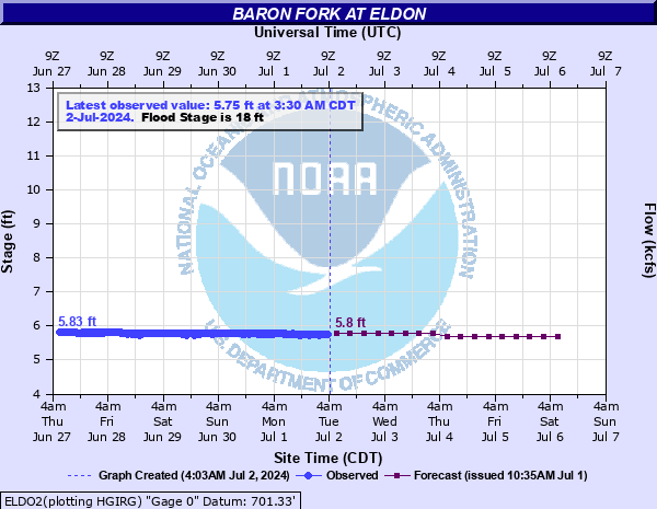
Latest Observation
Updated: 4:30 PM CST 12/15/25
Status: No Flooding
Stage: 5.9 ft
Flow: 0.0531 kcfs
Forecast
| Time | Stage (ft) | Flow (kcfs) |
|---|---|---|
| 6 PM 12/15 | 5.9 | 0.0531 |
| 12 AM 12/16 | 5.9 | 0.0531 |
| 6 AM 12/16 | 5.9 | 0.0531 |
| 12 PM 12/16 | 5.9 | 0.0531 |
| 6 PM 12/16 | 5.9 | 0.0531 |
| 12 AM 12/17 | 5.9 | 0.0531 |
| 6 AM 12/17 | 5.9 | 0.0531 |
| 12 PM 12/17 | 5.9 | 0.0531 |
| 6 PM 12/17 | 5.9 | 0.0531 |
| 12 AM 12/18 | 5.9 | 0.0531 |
| 6 AM 12/18 | 5.9 | 0.0531 |
| 12 PM 12/18 | 5.9 | 0.0531 |
| 6 PM 12/18 | 5.9 | 0.0531 |
| 12 AM 12/19 | 5.9 | 0.0531 |
| 6 AM 12/19 | 5.9 | 0.0531 |
| 12 PM 12/19 | 5.9 | 0.0531 |
| 6 PM 12/19 | 5.9 | 0.0531 |
| 12 AM 12/20 | 5.9 | 0.0531 |
| 6 AM 12/20 | 5.9 | 0.0531 |
| Time | Stage (ft) | Flow (kcfs) |
|---|---|---|
| 4:30 PM 12/15 | 5.9 | 0.0531 |
| 4:15 PM 12/15 | 5.86 | 0.0478 |
| 4:00 PM 12/15 | 5.9 | 0.0531 |
| 3:45 PM 12/15 | 5.86 | 0.0478 |
| 3:30 PM 12/15 | 5.85 | 0.0466 |
| 3:15 PM 12/15 | 5.85 | 0.0466 |
| 3:00 PM 12/15 | 5.85 | 0.0466 |
| 2:45 PM 12/15 | 5.85 | 0.0466 |
| 2:30 PM 12/15 | 5.86 | 0.0478 |
| 2:15 PM 12/15 | 5.86 | 0.0478 |
| 2:00 PM 12/15 | 5.87 | 0.0491 |
| 1:45 PM 12/15 | 5.87 | 0.0491 |
| 1:30 PM 12/15 | 5.85 | 0.0466 |
| 1:15 PM 12/15 | 5.86 | 0.0478 |
| 1:00 PM 12/15 | 5.85 | 0.0466 |
| 12:45 PM 12/15 | 5.84 | 0.0453 |
| 12:30 PM 12/15 | 5.85 | 0.0466 |
| 12:15 PM 12/15 | 5.87 | 0.0491 |
| 12:00 PM 12/15 | 5.85 | 0.0466 |
| 11:45 AM 12/15 | 5.85 | 0.0466 |
| 11:30 AM 12/15 | 5.85 | 0.0466 |
| 11:15 AM 12/15 | 5.85 | 0.0466 |
| 11:00 AM 12/15 | 5.84 | 0.0453 |
| 10:45 AM 12/15 | 5.86 | 0.0478 |
| 10:30 AM 12/15 | 5.85 | 0.0466 |
| 10:15 AM 12/15 | 5.86 | 0.0478 |
| 10:00 AM 12/15 | 5.87 | 0.0491 |
| 9:45 AM 12/15 | 5.89 | 0.0517 |
| 9:30 AM 12/15 | 5.85 | 0.0466 |
| 9:15 AM 12/15 | 5.89 | 0.0517 |
26' -
damaging flooding occurs. Significant areas of the Camp Egan campgrounds are flooded, including cabins. This is an extremely dangerous and life threatening situation.
24' -
severe flooding occurs. Large portions in the Camp Egan campgrounds are flooded, including some cabins. This is a dangerous situation.
22' -
moderate flooding occurs. Grazing lands become inundated to a depth of several feet. Floodwaters may reach some cabins near Camp Egan.
20' -
moderate flooding occurs. Grazing lands near the river become inundated. Low-lying areas near Camp Egan may experience minor flooding.
18' -
minor lowland flooding occurs.
| Date | Stage (ft) |
|---|---|
| Apr 25, 2011 | 28.51 |
| May 5, 2022 | 27.89 |
| Jun 21, 2000 | 26.77 |
| May 3, 1990 | 25.91 |
| May 4, 1990 | 25.8 |
| Oct 1, 1986 | 25.78 |
| Dec 27, 2015 | 25.44 |
| Apr 30, 2017 | 25.1 |
| Apr 24, 2004 | 24.54 |
| Apr 25, 2011 | 24.35 |
| Apr 15, 1945 | 23.8 |
| Nov 19, 1985 | 23.23 |
| Apr 20, 1976 | 22.73 |
| Oct 9, 2009 | 21.77 |
| Feb 21, 1997 | 21.6 |
| Jan 4, 1998 | 21.6 |
| Apr 17, 1990 | 21.59 |
| Sep 26, 1996 | 21.4 |
| Nov 25, 1973 | 21.23 |
| Oct 20, 1970 | 21.13 |
Data provided by the National Weather Service.