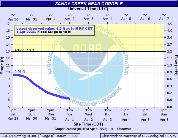
Sandy Creek near Cordele
Critical Stages
13' - Action
18' - Flood
19' - Moderate
21' - Major
Latest Observation
Updated: 10:15 PM CST 12/14/25
Status: No Flooding
Stage: 4.89 ft
Flow: 0.0016 kcfs
Forecast
Forecast not available for this location.
| Time | Stage (ft) | Flow (kcfs) |
|---|---|---|
| 10:15 PM 12/14 | 4.89 | 0.0016 |
| 10:00 PM 12/14 | 4.89 | 0.0016 |
| 9:45 PM 12/14 | 4.89 | 0.0016 |
| 9:30 PM 12/14 | 4.89 | 0.0016 |
| 9:15 PM 12/14 | 4.89 | 0.0016 |
| 9:00 PM 12/14 | 4.89 | 0.0016 |
| 8:45 PM 12/14 | 4.89 | 0.0016 |
| 8:30 PM 12/14 | 4.89 | 0.0016 |
| 8:15 PM 12/14 | 4.89 | 0.0016 |
| 8:00 PM 12/14 | 4.9 | 0.0016 |
| 7:45 PM 12/14 | 4.89 | 0.0016 |
| 7:30 PM 12/14 | 4.89 | 0.0016 |
| 7:15 PM 12/14 | 4.9 | 0.0016 |
| 7:00 PM 12/14 | 4.9 | 0.0016 |
| 6:45 PM 12/14 | 4.9 | 0.0016 |
| 6:30 PM 12/14 | 4.9 | 0.0016 |
| 6:15 PM 12/14 | 4.9 | 0.0016 |
| 6:00 PM 12/14 | 4.9 | 0.0016 |
| 5:45 PM 12/14 | 4.89 | 0.0016 |
| 5:30 PM 12/14 | 4.88 | 0.0015 |
| 5:15 PM 12/14 | 4.89 | 0.0016 |
| 5:00 PM 12/14 | 4.89 | 0.0016 |
| 4:45 PM 12/14 | 4.88 | 0.0015 |
| 4:30 PM 12/14 | 4.88 | 0.0015 |
| 4:15 PM 12/14 | 4.86 | 0.0015 |
| 4:00 PM 12/14 | 4.86 | 0.0015 |
| 3:45 PM 12/14 | 4.85 | 0.0014 |
| 3:30 PM 12/14 | 4.84 | 0.0014 |
| 3:15 PM 12/14 | 4.82 | 0.0013 |
| 3:00 PM 12/14 | 4.81 | 0.0013 |
27' -
Disastrous flooding is occurring. Roads and bridges in the floodplain are unpassable, and livestock well into the floodplain are threatened.
23' -
Major flooding is occurring with the creek over one third of a mile wide at FM 710 near the gage. Roads and bridges are completely inundated and dangerous to auto traffic. Livestock are threatened well into the floodplain.
21' -
Major lowland flooding begins with widespread inundation of the floodplain. The creek is one third of a mile wide at FM 710 in the vicinity of the gage. Primary roads and bridges are inundated and dangerous to motorists. Livestock are isolated and potentially drowned. Equipment in the floodplain are likely destroyed.
19' -
Moderate lowland flooding begins. Several roads and bridges in the floodplain are flooded and livestock in the floodplain are threatened.
18' -
Minor lowland flooding begins with the creek close to 200 yards wide at FM 710 in the vicinity of the gage. Secondary roads are cut off and bridges near the creek flood. Livestock are cut off and potentially drowned.
15' -
Livestock and equipment near the creek are threatened.
13' -
At levels above 13.0 feet, flows exceed the lowest areas along the creek.
| Date | Stage (ft) |
|---|---|
| Oct 19, 1998 | 32.72 |
| Oct 19, 1994 | 28.45 |
| Aug 30, 2017 | 25.84 |
| Nov 24, 2004 | 25.73 |
| Jun 19, 2015 | 24.61 |
| Sep 14, 1978 | 23.03 |
| Sep 1, 2001 | 20.84 |
| Feb 12, 1992 | 20.73 |
| Nov 13, 1985 | 20.46 |
| Jun 13, 1981 | 20.26 |
| Apr 20, 2016 | 20.25 |
| Jan 21, 1980 | 20.07 |
| Oct 14, 1997 | 20.03 |
| Sep 20, 1979 | 19.96 |
| Nov 5, 2002 | 19.96 |
| Jun 21, 1993 | 19.73 |
| Mar 18, 1997 | 19.64 |
| Jul 6, 2007 | 18.5 |
| Jul 11, 2021 | 18.42 |
| Apr 19, 2015 | 18.28 |
Data provided by the National Weather Service.