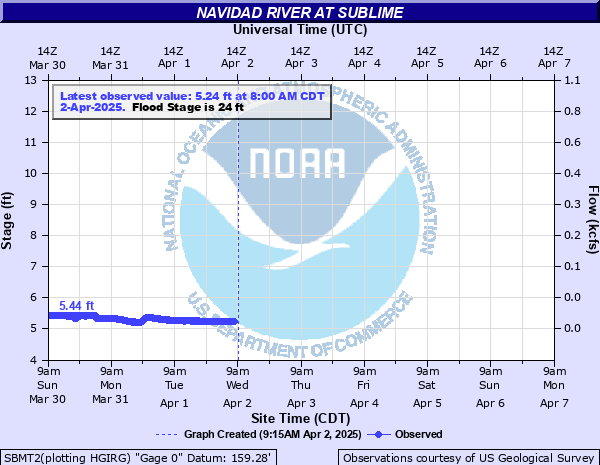
Navidad River at Sublime
Critical Stages
20' - Action
24' - Flood
25' - Moderate
26' - Major
Latest Observation
Updated: 10:00 PM CST 12/14/25
Status: No Flooding
Stage: 4.95 ft
Flow: 0.0031 kcfs
Forecast
Forecast not available for this location.
| Time | Stage (ft) | Flow (kcfs) |
|---|---|---|
| 10:00 PM 12/14 | 4.95 | 0.0031 |
| 9:45 PM 12/14 | 4.95 | 0.0031 |
| 9:30 PM 12/14 | 4.95 | 0.0031 |
| 9:15 PM 12/14 | 4.95 | 0.0031 |
| 9:00 PM 12/14 | 4.95 | 0.0031 |
| 8:45 PM 12/14 | 4.95 | 0.0031 |
| 8:30 PM 12/14 | 4.95 | 0.0031 |
| 8:15 PM 12/14 | 4.95 | 0.0031 |
| 8:00 PM 12/14 | 4.95 | 0.0031 |
| 7:45 PM 12/14 | 4.95 | 0.0031 |
| 7:30 PM 12/14 | 4.95 | 0.0031 |
| 7:15 PM 12/14 | 4.95 | 0.0031 |
| 7:00 PM 12/14 | 4.95 | 0.0031 |
| 6:45 PM 12/14 | 4.95 | 0.0031 |
| 6:30 PM 12/14 | 4.95 | 0.0031 |
| 6:15 PM 12/14 | 4.95 | 0.0031 |
| 6:00 PM 12/14 | 4.95 | 0.0031 |
| 5:45 PM 12/14 | 4.95 | 0.0031 |
| 5:30 PM 12/14 | 4.95 | 0.0031 |
| 5:15 PM 12/14 | 4.95 | 0.0031 |
| 5:00 PM 12/14 | 4.95 | 0.0031 |
| 4:45 PM 12/14 | 4.95 | 0.0031 |
| 4:30 PM 12/14 | 4.95 | 0.0031 |
| 4:15 PM 12/14 | 4.95 | 0.0031 |
| 4:00 PM 12/14 | 4.95 | 0.0031 |
| 3:45 PM 12/14 | 4.95 | 0.0031 |
| 3:30 PM 12/14 | 4.96 | 0.0031 |
| 3:15 PM 12/14 | 4.96 | 0.0031 |
| 3:00 PM 12/14 | 4.95 | 0.0031 |
| 2:45 PM 12/14 | 4.95 | 0.0031 |
34' -
Major lowland flooding continues with widespread inundation of the floodplain. The river is three quarters mile wide near Highway 90A and several homes along the river are flooded. Primary and secondary roads and low bridges are inundated and closed. Livestock in the floodplain are cut off and potentially drowned.
33' -
Major lowland flooding continues with the river one third mile wide at the Highway 90A bridge. Primary and secondary roads near the gauge are flooded and low bridges are very dangerous to auto traffic. Livestock are vulnerable to being cut off and drowned in the floodplain.
32' -
Major lowland flooding continues with the river one quarter mile wide at the Highway 90A bridge threatening livestock from the headwaters to below Speaks.
26' -
Major lowland flooding begins as two channels under the Highway 90A bridge merge becoming one channel several hundered yards wide. The lowest homes in the floodplain downstream near Vienna and in Jackson County are threatened.
25' -
Moderate lowland flooding begins threatening livestock, equipment, primary and secondary roads, and low bridges near the river.
24' -
Minor lowland flooding begins making secondary roads and low bridges near the river dangerous. Livestock and equipment should be removed from flood prone areas.
20' -
Flows exceed low-lying sections of both banks in the main channel.
| Date | Stage (ft) |
|---|---|
| Jun 1, 1940 | 40 |
| Jul 1, 1936 | 39 |
| Aug 28, 2017 | 36.38 |
| Sep 13, 1974 | 36.05 |
| Nov 23, 2004 | 33.76 |
| Sep 1, 1981 | 33.67 |
| Jun 13, 1973 | 32.91 |
| Oct 18, 1998 | 32.22 |
| Apr 19, 2016 | 31.81 |
| Apr 18, 2009 | 31.61 |
| Nov 1, 1981 | 31.15 |
| Oct 18, 1994 | 30.83 |
| Jun 7, 1979 | 30.45 |
| Sep 22, 1967 | 30.34 |
| Nov 5, 2002 | 30.27 |
| May 17, 1992 | 30.09 |
| Apr 21, 1977 | 30.01 |
| May 25, 1975 | 30 |
| Jun 8, 1997 | 29.14 |
| Oct 13, 1997 | 28.82 |
Data provided by the National Weather Service.