Genesee River at Mount Morris Dam
Critical Stages
720' - Action
760' - Flood
760' - Moderate
760' - Major
Latest Observation
Updated: 8:00 AM EST 12/6/25
Status: No Flooding
Stage: 587.47 ft
Flow: -999 kcfs
Forecast
| Time | Stage (ft) | Flow (kcfs) |
|---|---|---|
| 1 PM 12/6 | 587.2 | -999 |
| 7 PM 12/6 | 587.2 | -999 |
| 1 AM 12/7 | 587.2 | -999 |
| 7 AM 12/7 | 587.2 | -999 |
| 1 PM 12/7 | 587.2 | -999 |
| 7 PM 12/7 | 587.2 | -999 |
| 1 AM 12/8 | 587.2 | -999 |
| 7 AM 12/8 | 587.2 | -999 |
| Time | Stage (ft) | Flow (kcfs) |
|---|---|---|
| 8:00 AM 12/6 | 587.47 | -999 |
| 7:30 AM 12/6 | 587.52 | -999 |
| 7:00 AM 12/6 | 587.56 | -999 |
| 6:30 AM 12/6 | 587.59 | -999 |
| 6:00 AM 12/6 | 587.59 | -999 |
| 5:30 AM 12/6 | 587.57 | -999 |
| 5:00 AM 12/6 | 587.49 | -999 |
| 4:30 AM 12/6 | 587.41 | -999 |
| 4:00 AM 12/6 | 587.32 | -999 |
| 3:30 AM 12/6 | 587.21 | -999 |
| 3:00 AM 12/6 | 587.14 | -999 |
| 2:30 AM 12/6 | 587.1 | -999 |
| 2:00 AM 12/6 | 587.08 | -999 |
| 1:30 AM 12/6 | 587.08 | -999 |
| 1:00 AM 12/6 | 587.11 | -999 |
| 12:30 AM 12/6 | 587.12 | -999 |
| 12:00 AM 12/6 | 587.14 | -999 |
| 11:30 PM 12/5 | 587.14 | -999 |
| 11:00 PM 12/5 | 587.12 | -999 |
| 10:30 PM 12/5 | 587.09 | -999 |
| 10:00 PM 12/5 | 587.08 | -999 |
| 9:30 PM 12/5 | 587.09 | -999 |
| 9:00 PM 12/5 | 587.12 | -999 |
| 8:30 PM 12/5 | 587.19 | -999 |
| 8:00 PM 12/5 | 587.26 | -999 |
| 7:30 PM 12/5 | 587.33 | -999 |
| 7:00 PM 12/5 | 587.38 | -999 |
| 6:30 PM 12/5 | 587.39 | -999 |
| 6:00 PM 12/5 | 587.36 | -999 |
| 5:30 PM 12/5 | 587.28 | -999 |
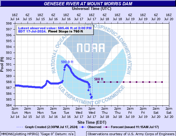
760' -
Flood stage, capacity of dam is reached. Spillway utilized. Dam must release flow. Major flooding likely downstream all the way to Rochester area. Co-ordination necessary among affected agencies for possible evacuations.
720' -
Action-alert stage. Pool significantly full. Increase monitoring.
600' -
Conservation pool, June 15 to November 1, maintained as close to this level as possible.
584' -
Pool elevation. Typical low level-uncontrolled.
575' -
River bed elevation.
| Date | Stage (ft) |
|---|---|
| Jun 23, 1972 | 755 |
Data provided by the National Weather Service.