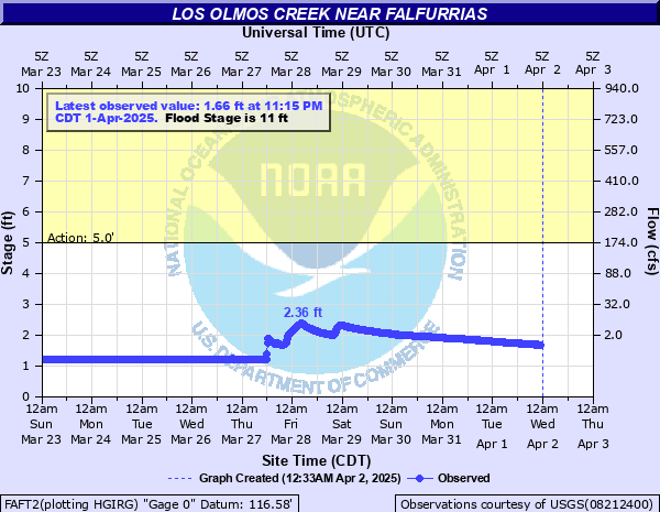
Los Olmos Creek near Falfurrias
Critical Stages
5' - Action
11' - Flood
12' - Moderate
13' - Major
Latest Observation
Updated: 2:15 PM CST 12/15/25
Status: No Flooding
Stage: 1.18 ft
Flow: -999 kcfs
Forecast
Forecast not available for this location.
| Time | Stage (ft) | Flow (kcfs) |
|---|---|---|
| 2:15 PM 12/15 | 1.18 | -999 |
| 2:00 PM 12/15 | 1.18 | -999 |
| 1:45 PM 12/15 | 1.18 | -999 |
| 1:30 PM 12/15 | 1.18 | -999 |
| 1:15 PM 12/15 | 1.18 | -999 |
| 1:00 PM 12/15 | 1.18 | -999 |
| 12:45 PM 12/15 | 1.18 | -999 |
| 12:30 PM 12/15 | 1.18 | -999 |
| 12:15 PM 12/15 | 1.18 | -999 |
| 12:00 PM 12/15 | 1.18 | -999 |
| 11:45 AM 12/15 | 1.18 | -999 |
| 11:30 AM 12/15 | 1.18 | -999 |
| 11:15 AM 12/15 | 1.18 | -999 |
| 11:00 AM 12/15 | 1.18 | -999 |
| 10:45 AM 12/15 | 1.18 | -999 |
| 10:30 AM 12/15 | 1.18 | -999 |
| 10:15 AM 12/15 | 1.18 | -999 |
| 10:00 AM 12/15 | 1.18 | -999 |
| 9:45 AM 12/15 | 1.18 | -999 |
| 9:30 AM 12/15 | 1.18 | -999 |
| 9:15 AM 12/15 | 1.18 | -999 |
| 9:00 AM 12/15 | 1.18 | -999 |
| 8:45 AM 12/15 | 1.18 | -999 |
| 8:30 AM 12/15 | 1.18 | -999 |
| 8:15 AM 12/15 | 1.18 | -999 |
| 8:00 AM 12/15 | 1.18 | -999 |
| 7:45 AM 12/15 | 1.18 | -999 |
| 7:30 AM 12/15 | 1.18 | -999 |
| 7:15 AM 12/15 | 1.18 | -999 |
| 7:00 AM 12/15 | 1.18 | -999 |
13' -
Major flooding with flow 750 feet wide and into the broad prevailing flood plain
12' -
Flood water has reached the base of US HWY 281 bridge north of Falfurrias.
11' -
Minor flooding with lowland flooding 300 feet wide into the flood plain
10' -
Flow escapes from the Los Olmos drainage into the Palo Blanco drainage area
9' -
Flow is high enough to close FM 1418 as water is covering the bridge.
7' -
Minor lowland flooding reaches 120 feet wide into flood plain-persons vulnerable to lowland flooding should move equipment to higher ground
| Date | Stage (ft) |
|---|---|
| Sep 13, 1951 | 15 |
| Aug 11, 1980 | 14.7 |
| Sep 13, 1971 | 12.66 |
| Jun 20, 2018 | 12.32 |
| Sep 24, 1967 | 11.79 |
| Jun 20, 2018 | 11.19 |
| Apr 19, 2010 | 9.92 |
Data provided by the National Weather Service.