« Back to Fort Fairfield Rivers
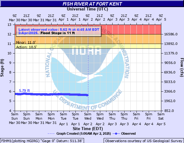
Fish River at Fort Kent
Critical Stages
10.5' - Action
11' - Flood
12' - Moderate
13' - Major
Latest Observation
Updated: 3:45 PM EST 12/15/25
Status: No Flooding
Stage: 3.69 ft
Flow: 0.56 kcfs
Forecast
Forecast not available for this location.
| Time | Stage (ft) | Flow (kcfs) |
|---|---|---|
| 4:45 PM 12/15 | 3.69 | 0.56 |
| 4:30 PM 12/15 | 3.69 | 0.56 |
| 4:15 PM 12/15 | 3.69 | 0.56 |
| 4:00 PM 12/15 | 3.69 | 0.56 |
| 3:45 PM 12/15 | 3.69 | 0.56 |
| 3:30 PM 12/15 | 3.69 | 0.56 |
| 3:15 PM 12/15 | 3.69 | 0.56 |
| 3:00 PM 12/15 | 3.69 | 0.56 |
| 2:45 PM 12/15 | 3.69 | 0.56 |
| 2:30 PM 12/15 | 3.69 | 0.56 |
| 2:15 PM 12/15 | 3.69 | 0.56 |
| 2:00 PM 12/15 | 3.69 | 0.56 |
| 1:45 PM 12/15 | 3.69 | 0.56 |
| 1:30 PM 12/15 | 3.69 | 0.56 |
| 1:15 PM 12/15 | 3.69 | 0.56 |
| 1:00 PM 12/15 | 3.69 | 0.56 |
| 12:45 PM 12/15 | 3.69 | 0.56 |
| 12:30 PM 12/15 | 3.69 | 0.56 |
| 12:15 PM 12/15 | 3.69 | 0.56 |
| 12:00 PM 12/15 | 3.69 | 0.56 |
| 11:45 AM 12/15 | 3.69 | 0.56 |
| 11:30 AM 12/15 | 3.69 | 0.56 |
| 11:15 AM 12/15 | 3.69 | 0.56 |
| 11:00 AM 12/15 | 3.69 | 0.56 |
| 10:45 AM 12/15 | 3.69 | 0.56 |
| 10:30 AM 12/15 | 3.69 | 0.56 |
| 10:15 AM 12/15 | 3.69 | 0.56 |
| 10:00 AM 12/15 | 3.69 | 0.56 |
| 9:45 AM 12/15 | 3.69 | 0.56 |
| 9:30 AM 12/15 | 3.69 | 0.56 |
16.5' -
Low sections of Bradbury Road in Fort Kent are flooded and homes inundated on the river side. Historic flooding on the Fish River chain of lakes resulting in significant flooding of camps and homes along the lakes.
14' -
Fort Kent Main Street bridge fully inundated with high water and impassable.
13' -
Major flooding. Dozens of homes or camps inundated from Portage Lake to Eagle Lake and downstream. River reaches the decking of the Main Street bridge in Fort Kent. The Blockhouse area and much of West Main Street in Fort Kent inundated.
12' -
Moderate flooding. Homes in the Soldier Pond area of Wallagrass threatened. West approach of Soldier Pond Bridge inundated with bridge closed. Dangerous flow begins to threaten the Fort Kent Main Street bridge.
11' -
Minor flooding. Water reaches the bottom of the Main Street bridge in Fort Kent. Water encroaches on properties along Bradbury Road in Fort Kent. Camps and some homes threatened on the Fish River from Wallagrass to Fort Kent. Fish River chain of lakes significantly elevated resulting in minor lake flooding.
10.5' -
River approaches bankfull from Fish River Falls downstream to the confluence with the St. John River.
| Date | Stage (ft) |
|---|---|
| Apr 30, 2008 | 13.93 |
| Apr 30, 1973 | 12.43 |
| May 3, 2018 | 12.02 |
| Apr 26, 1983 | 11.75 |
| May 16, 1961 | 11.49 |
| Apr 28, 2019 | 11.2 |
| Apr 30, 1979 | 11.11 |
| May 1, 2005 | 10.88 |
| May 11, 1969 | 10.88 |
| May 12, 1969 | 10.82 |
| Apr 26, 1958 | 10.81 |
| Apr 26, 1934 | 10.5 |
| May 5, 1942 | 10.45 |
| May 2, 1984 | 10.43 |
| May 4, 1934 | 10.3 |
| May 8, 1947 | 10.27 |
| May 5, 1955 | 10.25 |
| May 11, 1939 | 10.2 |
| May 5, 1933 | 10.15 |
| May 16, 1974 | 10.04 |
Data provided by the National Weather Service.