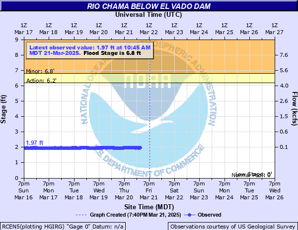
Rio Chama below El Vado Dam
Critical Stages
6.2' - Action
6.8' - Flood
9' - Moderate
12' - Major
Latest Observation
Updated: 10:45 PM MST 12/14/25
Status: No Flooding
Stage: 2.61 ft
Flow: 0.385 kcfs
Forecast
Forecast not available for this location.
| Time | Stage (ft) | Flow (kcfs) |
|---|---|---|
| 10:45 PM 12/14 | 2.61 | 0.385 |
| 10:30 PM 12/14 | 2.61 | 0.385 |
| 10:15 PM 12/14 | 2.61 | 0.385 |
| 10:00 PM 12/14 | 2.61 | 0.385 |
| 9:45 PM 12/14 | 2.61 | 0.385 |
| 9:30 PM 12/14 | 2.61 | 0.385 |
| 9:15 PM 12/14 | 2.61 | 0.385 |
| 9:00 PM 12/14 | 2.61 | 0.385 |
| 8:45 PM 12/14 | 2.61 | 0.385 |
| 8:30 PM 12/14 | 2.61 | 0.385 |
| 8:15 PM 12/14 | 2.61 | 0.385 |
| 8:00 PM 12/14 | 2.61 | 0.385 |
| 7:45 PM 12/14 | 2.61 | 0.385 |
| 7:30 PM 12/14 | 2.61 | 0.385 |
| 7:15 PM 12/14 | 2.61 | 0.385 |
| 7:00 PM 12/14 | 2.62 | 0.39 |
| 6:45 PM 12/14 | 2.61 | 0.385 |
| 6:30 PM 12/14 | 2.62 | 0.39 |
| 6:15 PM 12/14 | 2.62 | 0.39 |
| 6:00 PM 12/14 | 2.62 | 0.39 |
| 5:45 PM 12/14 | 2.62 | 0.39 |
| 5:30 PM 12/14 | 2.61 | 0.385 |
| 5:15 PM 12/14 | 2.62 | 0.39 |
| 5:00 PM 12/14 | 2.62 | 0.39 |
| 4:45 PM 12/14 | 2.61 | 0.385 |
| 4:30 PM 12/14 | 2.62 | 0.39 |
| 4:15 PM 12/14 | 2.62 | 0.39 |
| 4:00 PM 12/14 | 2.62 | 0.39 |
| 3:45 PM 12/14 | 2.61 | 0.385 |
| 3:30 PM 12/14 | 2.62 | 0.39 |
12' -
Cooper's El Vado Ranch and the Chama River RV Park and storage are getting flooded. The cabins nearest to the river will have water above the threshold of the doors.
9' -
Flood waters are beginning to encroach on the Chama River RV Park and Storage campground near Cooper's El Vado Ranch.
6.8' -
Low lying, mostly wild land along the riverbank begins to flood. Bank stability could be threatened and erosion is possible.
| Date | Stage (ft) |
|---|---|
| May 22, 1920 | 12 |
| May 7, 1985 | 7.08 |
| May 17, 1941 | 6.89 |
| May 20, 1973 | 6.82 |
| May 9, 2009 | 6.67 |
| May 23, 1995 | 6.39 |
| May 20, 2005 | 5.96 |
| May 18, 1994 | 5.88 |
Data provided by the National Weather Service.