« Back to Franconia Ridge Trail Rivers
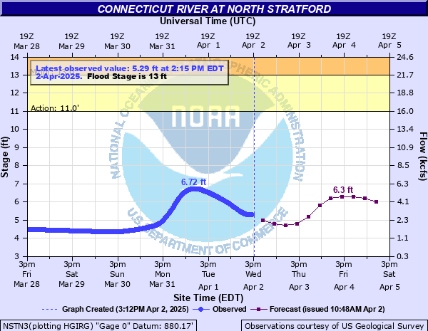
Connecticut River at North Stratford
Critical Stages
11' - Action
13' - Flood
16' - Moderate
19' - Major
Latest Observation
Updated: 1:15 PM EST 12/10/25
Status: No Flooding
Stage: 3.47 ft
Flow: 0.639 kcfs
Forecast
| Time | Stage (ft) | Flow (kcfs) |
|---|---|---|
| 7 PM 12/10 | 3.4 | 0.589 |
| 1 AM 12/11 | 3.4 | 0.589 |
| 7 AM 12/11 | 3.4 | 0.589 |
| 1 PM 12/11 | 3.4 | 0.589 |
| 7 PM 12/11 | 3.4 | 0.589 |
| 1 AM 12/12 | 3.4 | 0.589 |
| 7 AM 12/12 | 3.4 | 0.589 |
| 1 PM 12/12 | 3.4 | 0.589 |
| 7 PM 12/12 | 3.4 | 0.589 |
| 1 AM 12/13 | 3.4 | 0.589 |
| 7 AM 12/13 | 3.4 | 0.589 |
| Time | Stage (ft) | Flow (kcfs) |
|---|---|---|
| 1:15 PM 12/10 | 3.47 | 0.639 |
| 1:00 PM 12/10 | 3.46 | 0.632 |
| 12:45 PM 12/10 | 3.46 | 0.632 |
| 12:30 PM 12/10 | 3.46 | 0.632 |
| 12:15 PM 12/10 | 3.45 | 0.625 |
| 12:00 PM 12/10 | 3.45 | 0.625 |
| 11:45 AM 12/10 | 3.44 | 0.617 |
| 11:30 AM 12/10 | 3.43 | 0.61 |
| 11:15 AM 12/10 | 3.42 | 0.603 |
| 11:00 AM 12/10 | 3.4 | 0.589 |
| 10:45 AM 12/10 | 3.39 | 0.582 |
| 10:30 AM 12/10 | 3.37 | 0.568 |
| 10:15 AM 12/10 | 3.36 | 0.561 |
| 10:00 AM 12/10 | 3.35 | 0.554 |
| 9:45 AM 12/10 | 3.34 | 0.547 |
| 9:30 AM 12/10 | 3.33 | 0.541 |
| 9:15 AM 12/10 | 3.32 | 0.534 |
| 9:00 AM 12/10 | 3.32 | 0.534 |
| 8:45 AM 12/10 | 3.31 | 0.528 |
| 8:30 AM 12/10 | 3.31 | 0.528 |
| 8:15 AM 12/10 | 3.3 | 0.521 |
| 8:00 AM 12/10 | 3.3 | 0.521 |
| 7:45 AM 12/10 | 3.29 | 0.514 |
| 7:30 AM 12/10 | 3.29 | 0.514 |
| 7:15 AM 12/10 | 3.29 | 0.514 |
| 7:00 AM 12/10 | 3.29 | 0.514 |
| 6:45 AM 12/10 | 3.28 | 0.507 |
| 6:30 AM 12/10 | 3.28 | 0.507 |
| 6:15 AM 12/10 | 3.28 | 0.507 |
| 6:00 AM 12/10 | 3.28 | 0.507 |
20.6' -
Devastating flooding occurs. Many homes, businesses, and roads are flooded in New Hampshire and Vermont. Thousands of acres of farmland from Stewartstown, New Hampshire and Canaan, Vermont downstream to Maidstone, Vermont and Northumberland, New Hampshire is flooded.
19.3' -
This is the 100 year flood level. Route 3/Daniel Webster Highway is flooded. Many homes and businesses are flooded. Hundreds of acres of farmland are flooded in New Hampshire and Vermont.
16' -
In North Stratford, the town leach field and little league field are flooded. Flooding on Main Street is up to 3 feet deep. In Bloomfield, Vermont, portions of Route 102 are flooded. In addition, much farmland is flooded.
13' -
Main Street in North Stratford is flooded.
| Date | Stage (ft) |
|---|---|
| Mar 13, 1936 | 16.66 |
| Apr 3, 1959 | 16.11 |
| Mar 31, 1998 | 15.63 |
| Apr 27, 2011 | 14.9 |
| Jun 16, 1943 | 14.67 |
| Mar 19, 1936 | 14.64 |
| Jan 27, 1986 | 14.42 |
| Apr 16, 2014 | 14.25 |
| Mar 30, 1994 | 13.45 |
| Mar 30, 1993 | 13.45 |
| Apr 21, 2019 | 13.36 |
| Oct 17, 2005 | 13.35 |
| Mar 24, 1939 | 13.3 |
| Apr 1, 1987 | 13.17 |
| Mar 14, 1977 | 13.1 |
| Mar 27, 1988 | 13.08 |
| Jul 12, 2024 | 11.38 |
Data provided by the National Weather Service.