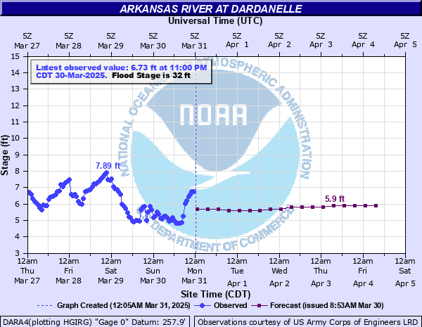
Arkansas River at Dardanelle
Critical Stages
32' - Action
32' - Flood
36' - Moderate
40' - Major
Latest Observation
Updated: 10:00 PM CST 12/14/25
Status: No Flooding
Stage: 6.62 ft
Flow: 17 kcfs
Forecast
| Time | Stage (ft) | Flow (kcfs) |
|---|---|---|
| 12 AM 12/15 | 5.8 | 8.41 |
| 6 AM 12/15 | 5.8 | 8.41 |
| 12 PM 12/15 | 5.8 | 8.41 |
| 6 PM 12/15 | 5.8 | 8.41 |
| 12 AM 12/16 | 5.8 | 8.41 |
| 6 AM 12/16 | 5.8 | 8.41 |
| 12 PM 12/16 | 5.8 | 8.41 |
| 6 PM 12/16 | 5.9 | 9.52 |
| 12 AM 12/17 | 5.9 | 9.52 |
| 6 AM 12/17 | 6 | 10.5 |
| 12 PM 12/17 | 6 | 10.5 |
| 6 PM 12/17 | 6 | 10.5 |
| 12 AM 12/18 | 6 | 10.5 |
| 6 AM 12/18 | 6 | 10.5 |
| 12 PM 12/18 | 5.9 | 9.52 |
| 6 PM 12/18 | 5.9 | 9.52 |
| 12 AM 12/19 | 5.8 | 8.41 |
| 6 AM 12/19 | 5.8 | 8.41 |
| Time | Stage (ft) | Flow (kcfs) |
|---|---|---|
| 10:00 PM 12/14 | 6.62 | 17 |
| 9:00 PM 12/14 | 6.47 | 15.2 |
| 8:00 PM 12/14 | 6.49 | 15.5 |
| 7:00 PM 12/14 | 6.59 | 16.7 |
| 6:00 PM 12/14 | 6.64 | 17.3 |
| 5:00 PM 12/14 | 5.49 | 5.64 |
| 4:00 PM 12/14 | 5.38 | 4.86 |
| 3:00 PM 12/14 | 5.66 | 7.04 |
| 2:00 PM 12/14 | 6.3 | 13.4 |
| 1:00 PM 12/14 | 6.57 | 16.4 |
| 12:00 PM 12/14 | 6.55 | 16.2 |
| 11:00 AM 12/14 | 7.28 | 25.1 |
| 10:00 AM 12/14 | 8.8 | 41.5 |
| 9:00 AM 12/14 | 8.76 | 41.1 |
| 8:00 AM 12/14 | 8.77 | 41.2 |
| 7:00 AM 12/14 | 8.73 | 40.9 |
| 6:00 AM 12/14 | 8.45 | 38 |
| 5:00 AM 12/14 | 7.48 | 27.8 |
| 4:00 AM 12/14 | 7.3 | 25.4 |
| 3:00 AM 12/14 | 7.35 | 26 |
| 2:00 AM 12/14 | 7.26 | 24.9 |
| 1:00 AM 12/14 | 7.18 | 23.9 |
| 12:00 AM 12/14 | 7.08 | 22.7 |
| 11:00 PM 12/13 | 6.98 | 21.5 |
| 10:00 PM 12/13 | 6.93 | 21 |
| 9:00 PM 12/13 | 6.91 | 20.8 |
| 8:00 PM 12/13 | 6.85 | 20.1 |
| 7:00 PM 12/13 | 6.69 | 17.9 |
| 6:00 PM 12/13 | 6.64 | 17.3 |
| 5:00 PM 12/13 | 6.62 | 17 |
44' -
Serious flooding expected, overtopping of Dardanelle Drainage District Levee possible. Flood of record prior to completion of the flood control reservoirs and the navigation system was 44.1 feet in May 1943.
41' -
Major flooding expected, levee patrolling begins. December 2015 flood crested at 40.8 feet. May 1990 flood crested at 41.6 feet. Several highways and numerous county roads flooded.
36' -
Moderate flood conditions expected with numerous roads and highways affected, backwater up Petit Jean River floods State Highway 154. Carden Bottoms and Holla Bend National Wildlife Refuge flooded.
35' -
State Highway 155 in Yell County and County Roads inside the levee flooded. About 5000 acres of farmland flooded.
34' -
Approximately 2000 acres of farmland flooded. Galla Creek Wildlife Management area partially flooded and State Highway 105 along the river may be affected.
32' -
Minor flooding, commercial and industrial areas along the river in Dardanelle and Russellville may be affected. Lower lying agricultural land within the levee starts to flood.
| Date | Stage (ft) |
|---|---|
| May 30, 2019 | 45.91 |
| May 25, 1943 | 44.1 |
| May 30, 1957 | 43.4 |
| Apr 19, 1945 | 43.15 |
| Apr 19, 1927 | 43 |
| May 4, 1990 | 41.6 |
| Dec 29, 2015 | 40.83 |
| Apr 23, 1973 | 40.5 |
| Dec 3, 1982 | 40.02 |
| Oct 10, 1986 | 38 |
| May 28, 2015 | 37.73 |
| May 12, 2015 | 37 |
| Apr 11, 2008 | 36.27 |
| Mar 19, 2008 | 34.85 |
| Apr 27, 2011 | 34.52 |
| May 13, 1993 | 33.6 |
| Jun 16, 1995 | 33.38 |
| Jan 5, 1993 | 33.3 |
| Dec 16, 1992 | 33 |
| Jan 6, 1998 | 32.91 |
Data provided by the National Weather Service.