« Back to Greenfield Community College Rivers
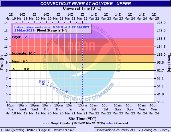
Connecticut River at Holyoke - Upper
Critical Stages
8' - Action
9' - Flood
10' - Moderate
12' - Major
Latest Observation
Updated: 7:03 PM LMT 12/31/00
Status: Obs Not Current
Stage: -999 ft
Flow: -999 kcfs
Forecast
Forecast not available for this location.
| Time | Stage (ft) | Flow (kcfs) |
|---|---|---|
| 7:00 AM 12/7 | 3.03 | 20.3 |
| 7:00 AM 12/6 | 3.16 | 21.6 |
| 7:08 AM 12/5 | 3.06 | 20.6 |
| 7:02 AM 12/4 | 3.13 | 21.3 |
| 6:18 AM 12/2 | 3.09 | 20.9 |
| 6:36 AM 12/1 | 3.15 | 21.5 |
| 6:50 AM 11/29 | 2.96 | -999 |
| 7:40 AM 11/26 | 2.98 | -999 |
| 8:41 AM 11/21 | 3.06 | 20.6 |
| 8:06 AM 11/20 | 3.19 | 21.9 |
| 6:57 AM 11/19 | 3.99 | 30.7 |
| 7:33 AM 11/17 | 2.99 | -999 |
| 7:32 AM 11/14 | 2.83 | -999 |
| 7:01 AM 11/12 | 3.55 | 25.7 |
| 6:37 AM 11/11 | 3.1 | 21 |
| 7:46 AM 11/10 | 2.93 | -999 |
| 7:23 AM 11/9 | 3.12 | 21.2 |
| 7:13 AM 11/8 | 3.06 | 20.6 |
16' -
This is a serious flood situation. Widespread flooding along the Connecticut River from Hatfield and Hadley to Holyoke is likely. Action must be taken immediately to protect life and property. Follow the directions of your local emergency management officials. If you are asked to evacuate do so immediately.
12' -
Flooding along portions of Route 5 mainly north of Holyoke is expected. Some roadways may be closed due to flooding.
9' -
Lowland flooding in portions of Easthampton and South Hadley is likely.
| Date | Stage (ft) |
|---|---|
| Mar 19, 1936 | 16.799999237061 |
| Sep 22, 1938 | 14.9 |
| Nov 5, 1927 | 14.75 |
| Apr 20, 1933 | 13.2 |
| Oct 5, 1869 | 12.7 |
| Mar 29, 1913 | 12.7 |
| Apr 20, 1862 | 12.5 |
| Apr 8, 1901 | 12.1 |
| May 31, 1984 | 12.01 |
| Apr 6, 1960 | 12 |
| Apr 13, 1922 | 11.9 |
| Mar 4, 1902 | 11.9 |
| Jan 1, 1949 | 11.6 |
| Mar 23, 1948 | 11.4 |
| Apr 1, 1905 | 11.2 |
| Apr 16, 1909 | 11.2 |
| Mar 24, 1903 | 11.1 |
| Jun 3, 1952 | 10.95 |
| May 5, 1940 | 10.9 |
| Apr 14, 1934 | 10.8 |
Data provided by the National Weather Service.