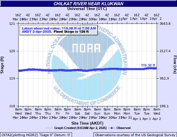
Chilkat River near Klukwan
Critical Stages
125.5' - Action
126' - Flood
129' - Moderate
130.5' - Major
Latest Observation
Updated: 1:00 PM AKST 12/16/25
Status: No Flooding
Stage: 120.15 ft
Flow: 1.18 kcfs
Forecast
Forecast not available for this location.
| Time | Stage (ft) | Flow (kcfs) |
|---|---|---|
| 1:00 PM 12/16 | 120.15 | 1.18 |
| 12:45 PM 12/16 | 120.15 | 1.18 |
| 12:30 PM 12/16 | 120.15 | 1.18 |
| 12:15 PM 12/16 | 120.15 | 1.18 |
| 12:00 PM 12/16 | 120.15 | 1.18 |
| 11:45 AM 12/16 | 120.15 | 1.18 |
| 11:30 AM 12/16 | 120.15 | 1.18 |
| 11:15 AM 12/16 | 120.15 | 1.18 |
| 11:00 AM 12/16 | 120.15 | 1.18 |
| 10:45 AM 12/16 | 120.15 | 1.18 |
| 10:30 AM 12/16 | 120.15 | 1.18 |
| 10:15 AM 12/16 | 120.15 | 1.18 |
| 10:00 AM 12/16 | 120.15 | 1.18 |
| 9:45 AM 12/16 | 120.15 | 1.18 |
| 9:30 AM 12/16 | 120.15 | 1.18 |
| 9:15 AM 12/16 | 120.15 | 1.18 |
| 8:00 AM 12/16 | 120.15 | 1.18 |
| 7:45 AM 12/16 | 120.14 | 1.17 |
| 7:30 AM 12/16 | 120.14 | 1.17 |
| 7:15 AM 12/16 | 120.15 | 1.18 |
| 7:00 AM 12/16 | 120.14 | 1.17 |
| 6:45 AM 12/16 | 120.14 | 1.17 |
| 6:30 AM 12/16 | 120.14 | 1.17 |
| 6:15 AM 12/16 | 120.15 | 1.18 |
| 6:00 AM 12/16 | 120.14 | 1.17 |
| 5:45 AM 12/16 | 120.15 | 1.18 |
| 5:30 AM 12/16 | 120.15 | 1.18 |
| 5:15 AM 12/16 | 120.15 | 1.18 |
| 5:00 AM 12/16 | 120.15 | 1.18 |
| 4:45 AM 12/16 | 120.15 | 1.18 |
134.75' -
Water level will reach the base of the Haines Highway Chilkat River bridge horizontal I-beam, and the top of the concrete bridge abutment.
134.5' -
Water level at the concrete foundation of the log cabin closest to the Chilkat River bridge on the left downstream overbank area.
130.5' -
This is the estimate stage where there will be significant damage to buildings at the Chilkat River Adventures and longhouses at the Jilkaat Kwan Cultural Heritage Center Campus Traditional Knowledge camp in Klukwan.
129' -
Water will approach the top of the erosion control dike protecting the longhouse at the Jilkaat Kwan Cultural Heritage Center Campus Traditional Knowledge camp in Klukwan and begin to impact the concrete footers of nearby longhouses and other structures. Entire backyards along the Chilkat River in Klukwan will be flooded impacting numerous smokehouses and other storage buildings.
128.5' -
Water will flood the property of Chilkat River Adventures just upstream of the Haines Highway Chilkat River bridge with some other minor flooding near mile post 14 and 25 boat launches and along Porcupine Road. Flooding will impact most backyards along the Chilkat River in Klukwan including storage sheds, smokehouses and other out buildings. Significant bank erosion is expected near the Jilkaat Kwan Cultural Heritage Center Campus Traditional Knowledge camp.
128' -
Water will begin to flow over the driveway into the property of Chilkat River Adventures just upstream of the Haines Highway Chilkat River bridge. Minor flooding may occur near mile post 14 and 25 boat launches along with minor flooding of Porcupine Road. Flooding of backyards along the Chilkat River in Klukwan will get worse.
127.5' -
Lower elevations in backyards along the Chilkat River in Klukwan will be underwater, and a river access road, smokehouses and storage sheds will flood. Bank erosion is expected to increase near Jilkaat Kwan Cultural Heritage Center Campus Traditional Knowledge camp.
126.5' -
Expect flooding of yards and bank erosion near the Jilkaat Kwan Cultural Heritage Center Campus Traditional Knowledge camp in the village of Klukwan. Water will flood lower elevations in backyards along the Chilkat River near Klukwan and start to impact some smokehouse and a river access road.
126' -
Bankfull stage. Water will begin to flood backyards along the Chilkat River in the village of Klukwan.
| Date | Stage (ft) |
|---|---|
| Jun 29, 2021 | 128.18 |
| Jul 25, 2024 | 128.06 |
| Jun 26, 2012 | 127.97 |
| Oct 2, 2022 | 127.89 |
| Sep 8, 2017 | 127.8 |
| Sep 10, 2018 | 127.8 |
| Jul 5, 2014 | 127.67 |
| Oct 14, 2022 | 127.67 |
| Jun 27, 2013 | 127.36 |
| Sep 27, 2022 | 127.35 |
| Jun 7, 2022 | 127.24 |
| Jul 3, 2019 | 127.2 |
| Aug 18, 2022 | 127.16 |
| Jun 29, 2022 | 127.07 |
| Jul 29, 2024 | 127.07 |
| Sep 4, 2022 | 126.97 |
| Jul 16, 2024 | 126.89 |
| Oct 20, 2022 | 126.84 |
| Jun 20, 2024 | 126.7 |
| Jun 29, 2023 | 126.69 |
Data provided by the National Weather Service.