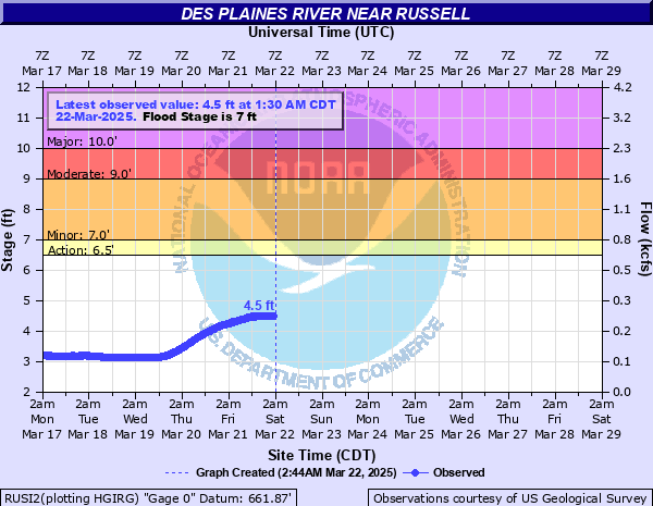
Des Plaines River near Russell
Critical Stages
6.5' - Action
7' - Flood
9' - Moderate
10' - Major
Latest Observation
Updated: 5:30 AM CST 12/11/25
Status: No Flooding
Stage: 3.79 ft
Flow: 0.0107 kcfs
Forecast
Forecast not available for this location.
| Time | Stage (ft) | Flow (kcfs) |
|---|---|---|
| 5:30 AM 12/11 | 3.79 | 0.0107 |
| 5:15 AM 12/11 | 3.79 | 0.0107 |
| 5:00 AM 12/11 | 3.78 | 0.0103 |
| 4:45 AM 12/11 | 3.78 | 0.0103 |
| 4:30 AM 12/11 | 3.78 | 0.0103 |
| 4:15 AM 12/11 | 3.78 | 0.0103 |
| 4:00 AM 12/11 | 3.78 | 0.0103 |
| 3:45 AM 12/11 | 3.78 | 0.0103 |
| 3:30 AM 12/11 | 3.77 | 0.01 |
| 3:15 AM 12/11 | 3.77 | 0.01 |
| 3:00 AM 12/11 | 3.77 | 0.01 |
| 2:45 AM 12/11 | 3.77 | 0.01 |
| 2:30 AM 12/11 | 3.77 | 0.01 |
| 2:15 AM 12/11 | 3.77 | 0.01 |
| 2:00 AM 12/11 | 3.76 | 0.0097 |
| 1:45 AM 12/11 | 3.76 | 0.0097 |
| 1:30 AM 12/11 | 3.76 | 0.0097 |
| 1:15 AM 12/11 | 3.76 | 0.0097 |
| 1:00 AM 12/11 | 3.76 | 0.0097 |
| 12:45 AM 12/11 | 3.75 | 0.0094 |
| 12:30 AM 12/11 | 3.75 | 0.0094 |
| 12:15 AM 12/11 | 3.75 | 0.0094 |
| 12:00 AM 12/11 | 3.75 | 0.0094 |
| 11:45 PM 12/10 | 3.75 | 0.0094 |
| 11:30 PM 12/10 | 3.75 | 0.0094 |
| 11:15 PM 12/10 | 3.74 | 0.0091 |
| 11:00 PM 12/10 | 3.74 | 0.0091 |
| 10:45 PM 12/10 | 3.74 | 0.0091 |
| 10:30 PM 12/10 | 3.74 | 0.0091 |
| 10:15 PM 12/10 | 3.74 | 0.0091 |
16' -
Commercial parking lots threatened along Skokie Highway (US-41).
15' -
Kilbourne Road threatened.
13.5' -
Wadsworth Road threatened in Wadsworth.
13' -
Skokie Highway (US-41) threatened south of Wadsworth Road in Wadsworth. Widespread inundation reaches up to a half mile from the river in Russell and Wadsworth.
12.5' -
Rosecrans Road (IL-173) threatened near Wadsworth.
12' -
Residential structures threatened along Ingram Drive. Russell Road threatened. Roadways and trails threatened at Van Patten Woods Forest Preserve.
9.5' -
Residential structures threatened along Russell Road between the river and Kilbourne Road.
8' -
Agricultural and park land is inundated near the river. Residential property is threatened near the river.
7' -
Low-lying wetlands and agricultural land is inundated near the river.
| Date | Stage (ft) |
|---|---|
| Jul 14, 2017 | 12.11 |
| May 23, 2004 | 11.09 |
| Sep 27, 1986 | 10.75 |
| Mar 6, 1976 | 10.75 |
| Aug 24, 2007 | 10.51 |
| Sep 15, 2019 | 10.48 |
| Aug 21, 1978 | 10.31 |
| Jun 21, 2009 | 10.01 |
| Apr 19, 2013 | 9.99 |
| Jun 14, 2000 | 9.95 |
| Feb 23, 1994 | 9.95 |
| Apr 4, 1983 | 9.89 |
| Apr 2, 1960 | 9.69 |
| Mar 21, 1979 | 9.69 |
| Jun 11, 2008 | 9.47 |
| Sep 22, 1972 | 9.4 |
| Mar 5, 1974 | 9.3 |
| May 1, 2020 | 9.03 |
| Mar 15, 1990 | 8.96 |
| May 20, 2020 | 8.9 |
Data provided by the National Weather Service.