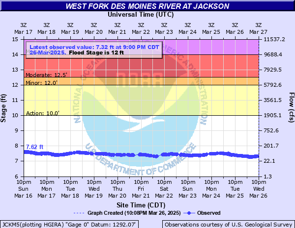
West Fork Des Moines River at Jackson
Critical Stages
10' - Action
12' - Flood
12.5' - Moderate
14' - Major
Latest Observation
Updated: 3:00 PM CST 12/15/25
Status: No Flooding
Stage: 7.36 ft
Flow: 0.0575 kcfs
Forecast
Forecast not available for this location.
| Time | Stage (ft) | Flow (kcfs) |
|---|---|---|
| 3:00 PM 12/15 | 7.36 | 0.0575 |
| 2:45 PM 12/15 | 7.36 | 0.0575 |
| 2:30 PM 12/15 | 7.36 | 0.0575 |
| 2:15 PM 12/15 | 7.36 | 0.0575 |
| 2:00 PM 12/15 | 7.36 | 0.0575 |
| 1:45 PM 12/15 | 7.36 | 0.0575 |
| 1:30 PM 12/15 | 7.36 | 0.0575 |
| 1:15 PM 12/15 | 7.36 | 0.0575 |
| 1:00 PM 12/15 | 7.36 | 0.0575 |
| 12:45 PM 12/15 | 7.36 | 0.0575 |
| 12:30 PM 12/15 | 7.36 | 0.0575 |
| 12:15 PM 12/15 | 7.36 | 0.0575 |
| 12:00 PM 12/15 | 7.36 | 0.0575 |
| 11:45 AM 12/15 | 7.36 | 0.0575 |
| 11:30 AM 12/15 | 7.36 | 0.0575 |
| 11:15 AM 12/15 | 7.36 | 0.0575 |
| 11:00 AM 12/15 | 7.36 | 0.0575 |
| 10:45 AM 12/15 | 7.36 | 0.0575 |
| 10:30 AM 12/15 | 7.36 | 0.0575 |
| 10:15 AM 12/15 | 7.36 | 0.0575 |
| 10:00 AM 12/15 | 7.37 | 0.0588 |
| 9:45 AM 12/15 | 7.36 | 0.0575 |
| 9:30 AM 12/15 | 7.36 | 0.0575 |
| 9:15 AM 12/15 | 7.37 | 0.0588 |
| 9:00 AM 12/15 | 7.37 | 0.0588 |
| 8:45 AM 12/15 | 7.37 | 0.0588 |
| 8:30 AM 12/15 | 7.37 | 0.0588 |
| 8:15 AM 12/15 | 7.37 | 0.0588 |
| 8:00 AM 12/15 | 7.37 | 0.0588 |
| 7:45 AM 12/15 | 7.37 | 0.0588 |
19' -
The bridge on Hwy 71 in Jackson is overtopped.
17.5' -
The highest levees in Jackson are overtopped causing major flooding of roads, homes, and businesses in Jackson.
15' -
The low portions of River St begin to flood.
14' -
Highway 71 will begin flooding, and flooding begins to affect homes and businesses along the non-leveed portions of the river in Jackson. Most of Ashley Park is flooded and the baseball fields are under 3-4 feet of water.
13.5' -
The lower levees in Jackson are overtopped. Water begins to approach the edge of Highway 71 in Jackson and may approach some structures. Water reaches the bottom of the bridge on W Ashley St.
12.5' -
The parks and softball fields in Jackson begin to flood.
12' -
Some township roads may begin flooding and flooding of crop and pasture lands becomes more widespread. Portions of the bike trail in Jackson along the river begin to flood.
10' -
Flooding of lowland agricultural areas and low-water crossings begins.
| Date | Stage (ft) |
|---|---|
| Jun 26, 2024 | 16.04 |
| Mar 24, 2019 | 14.08 |
| Jul 8, 2018 | 13.92 |
| Apr 18, 2023 | 10.77 |
| Apr 4, 2020 | 10.64 |
| May 26, 2017 | 10.5 |
| Jun 14, 2022 | 10.36 |
| Apr 12, 2021 | 9.02 |
Data provided by the National Weather Service.