« Back to Hapuna Beach State Park Rivers
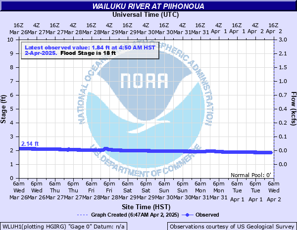
Wailuku River at Piihonoua
Critical Stages
Action
20' - Flood
Moderate
24.4' - Major
Latest Observation
Updated: 5:50 PM HST 12/14/25
Status: No Flooding
Stage: 1.81 ft
Flow: 0.0214 kcfs
Forecast
Forecast not available for this location.
| Time | Stage (ft) | Flow (kcfs) |
|---|---|---|
| 6:50 PM 12/14 | 1.8 | 0.021 |
| 6:45 PM 12/14 | 1.81 | 0.0214 |
| 6:40 PM 12/14 | 1.8 | 0.021 |
| 6:35 PM 12/14 | 1.8 | 0.021 |
| 6:30 PM 12/14 | 1.8 | 0.021 |
| 6:25 PM 12/14 | 1.8 | 0.021 |
| 6:20 PM 12/14 | 1.8 | 0.021 |
| 6:15 PM 12/14 | 1.8 | 0.021 |
| 6:10 PM 12/14 | 1.8 | 0.021 |
| 6:05 PM 12/14 | 1.81 | 0.0214 |
| 6:00 PM 12/14 | 1.8 | 0.021 |
| 5:55 PM 12/14 | 1.81 | 0.0214 |
| 5:50 PM 12/14 | 1.81 | 0.0214 |
| 5:45 PM 12/14 | 1.8 | 0.021 |
| 5:40 PM 12/14 | 1.81 | 0.0214 |
| 5:35 PM 12/14 | 1.81 | 0.0214 |
| 5:30 PM 12/14 | 1.8 | 0.021 |
| 5:25 PM 12/14 | 1.81 | 0.0214 |
| 5:20 PM 12/14 | 1.81 | 0.0214 |
| 5:15 PM 12/14 | 1.8 | 0.021 |
| 5:10 PM 12/14 | 1.81 | 0.0214 |
| 5:05 PM 12/14 | 1.81 | 0.0214 |
| 5:00 PM 12/14 | 1.8 | 0.021 |
| 4:55 PM 12/14 | 1.81 | 0.0214 |
| 4:50 PM 12/14 | 1.81 | 0.0214 |
| 4:45 PM 12/14 | 1.81 | 0.0214 |
| 4:40 PM 12/14 | 1.8 | 0.021 |
| 4:35 PM 12/14 | 1.81 | 0.0214 |
| 4:30 PM 12/14 | 1.81 | 0.0214 |
| 4:25 PM 12/14 | 1.8 | 0.021 |
21' -
Flooding affecting homes and properties in Piihonua. Also an indirect indicator of Alenaio Stream in downtown Hilo at maximum capacity. Bayfront area flooding. Kamehameha Ave. and lower Pauahi St. closed. Other normally flood prone roads also closed.
Historical crest information is not available.
Data provided by the National Weather Service.