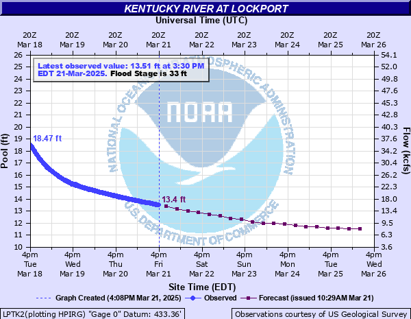
Kentucky River at Lockport
Critical Stages
30' - Action
33' - Flood
43' - Moderate
49' - Major
Latest Observation
Updated: 11:30 PM EST 12/14/25
Status: No Flooding
Stage: 10.03 ft
Flow: 3.63 kcfs
Forecast
| Time | Stage (ft) | Flow (kcfs) |
|---|---|---|
| 1 AM 12/15 | 10 | 3.57 |
| 7 AM 12/15 | 10 | 3.57 |
| 1 PM 12/15 | 9.9 | 3.33 |
| 7 PM 12/15 | 10 | 3.57 |
| 1 AM 12/16 | 10 | 3.57 |
| 7 AM 12/16 | 10 | 3.57 |
| 1 PM 12/16 | 10 | 3.57 |
| 7 PM 12/16 | 10 | 3.57 |
| 1 AM 12/17 | 10 | 3.57 |
| 7 AM 12/17 | 10 | 3.57 |
| 1 PM 12/17 | 10.1 | 3.8 |
| 7 PM 12/17 | 10.2 | 4.05 |
| 1 AM 12/18 | 10.3 | 4.31 |
| 7 AM 12/18 | 10.4 | 4.57 |
| 1 PM 12/18 | 10.4 | 4.57 |
| 7 PM 12/18 | 10.4 | 4.57 |
| 1 AM 12/19 | 10.4 | 4.57 |
| 7 AM 12/19 | 10.4 | 4.57 |
| Time | Stage (ft) | Flow (kcfs) |
|---|---|---|
| 11:30 PM 12/14 | 10.03 | 3.63 |
| 11:15 PM 12/14 | 10.02 | 3.61 |
| 11:00 PM 12/14 | 10.02 | 3.61 |
| 10:45 PM 12/14 | 10.02 | 3.61 |
| 10:30 PM 12/14 | 10.02 | 3.61 |
| 10:15 PM 12/14 | 10.02 | 3.61 |
| 10:00 PM 12/14 | 10.02 | 3.61 |
| 9:45 PM 12/14 | 10.01 | 3.59 |
| 9:30 PM 12/14 | 10.01 | 3.59 |
| 9:15 PM 12/14 | 10.01 | 3.59 |
| 9:00 PM 12/14 | 10.01 | 3.59 |
| 8:45 PM 12/14 | 10.01 | 3.59 |
| 8:30 PM 12/14 | 10.01 | 3.59 |
| 8:15 PM 12/14 | 10.01 | 3.59 |
| 8:00 PM 12/14 | 10 | 3.57 |
| 7:45 PM 12/14 | 10 | 3.57 |
| 7:30 PM 12/14 | 10 | 3.57 |
| 7:15 PM 12/14 | 9.99 | 3.54 |
| 7:00 PM 12/14 | 9.99 | 3.54 |
| 6:45 PM 12/14 | 9.99 | 3.54 |
| 6:30 PM 12/14 | 9.99 | 3.54 |
| 6:15 PM 12/14 | 9.98 | 3.52 |
| 6:00 PM 12/14 | 9.98 | 3.52 |
| 5:45 PM 12/14 | 9.98 | 3.52 |
| 5:30 PM 12/14 | 9.98 | 3.52 |
| 5:15 PM 12/14 | 9.97 | 3.5 |
| 5:00 PM 12/14 | 9.97 | 3.5 |
| 4:45 PM 12/14 | 9.97 | 3.5 |
| 4:30 PM 12/14 | 9.97 | 3.5 |
| 4:15 PM 12/14 | 9.96 | 3.47 |
54' -
Low lying roads near the river along and west of KY 355 flood.
51' -
More than half of Monterey floods. Water is four feet deep in homes closest to the river. Water is up to two feet deep on Taylor St. Flooding may occur in low lying buildings along Crittenden Street in Gratz.
49' -
Some homes in Monterey along High Street and Worth streets likely flood, with Taylor Street west of town flooded. Long stretches of Old Landing Road and Point of Rock Road are flooded. Water approaches homes along Crittenden Street in Gratz, with stretches of Ky Route 355 and Crittenden Road flooded.
47' -
Some homes in Monterey near High Street flood, with Point of Rock Road and long stretches of Old Landing Road flooded.
45' -
Water surrounds some homes on High Street in Monterey. Point of Rock and Old Landing Rd flood in several areas. Route 355 near Gratz is flooded, as well as Crittenden Street east of town.
43' -
KY 389 floods near Lockport. Water approaches some homes along High St. in Monterey. Some stretches of 355 north of Perry Park flood, as well as near Gratz.
41' -
Water approaches some outbuildings and barns in Monterey. Some yards beetween Eagle Lane and the river in Perry Park flood, with flooding along some low areas of Old Landing Road.
36' -
Low areas of Point of Rock and Old Landing Roads, with water encroaching on low lying roads near Perry Park and Monterey.
33' -
Low lying roads near the river along and west of KY 355 flood.
30' -
Parts of Eagle Creek campground, between Worthville and Perry, flood along KY 355.
| Date | Stage (ft) |
|---|---|
| Jan 26, 1937 | 56.85 |
| Apr 7, 2025 | 53.62 |
| Mar 6, 1997 | 53.6 |
| Dec 11, 1978 | 51.65 |
| Feb 17, 1989 | 49.14 |
| Mar 11, 1964 | 49 |
| Apr 17, 1972 | 47.1 |
| Mar 3, 1962 | 46.87 |
| Mar 7, 1945 | 46.7 |
| May 5, 2010 | 45.92 |
| Mar 6, 2021 | 45.87 |
| Feb 18, 2025 | 45.67 |
| Mar 28, 1913 | 45.5 |
| Mar 6, 1955 | 44.25 |
| Feb 3, 1950 | 43.8 |
| May 10, 1984 | 43.71 |
| Apr 14, 1948 | 43.5 |
| May 9, 1961 | 43.15 |
| Apr 5, 2015 | 43.04 |
| Feb 25, 1909 | 43 |
Data provided by the National Weather Service.