Stoner Creek at Paris
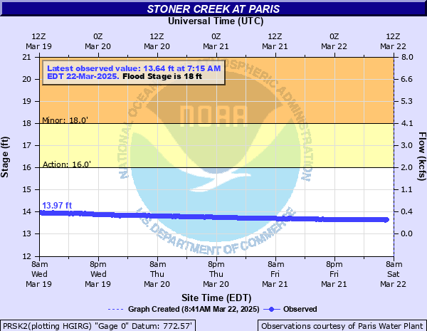
Critical Stages
16' - Action
18' - Flood
22' - Moderate
25' - Major
Latest Observation
Updated: 12:15 AM EST 12/15/25
Status: No Flooding
Stage: 13.82 ft
Flow: 0.236 kcfs
Forecast
Forecast not available for this location.
| Time | Stage (ft) | Flow (kcfs) |
|---|---|---|
| 1:15 AM 12/15 | 13.83 | 0.241 |
| 1:00 AM 12/15 | 13.82 | 0.236 |
| 12:45 AM 12/15 | 13.82 | 0.236 |
| 12:30 AM 12/15 | 13.82 | 0.236 |
| 12:15 AM 12/15 | 13.82 | 0.236 |
| 12:00 AM 12/15 | 13.82 | 0.236 |
| 11:45 PM 12/14 | 13.82 | 0.236 |
| 11:30 PM 12/14 | 13.82 | 0.236 |
| 11:15 PM 12/14 | 13.82 | 0.236 |
| 11:00 PM 12/14 | 13.82 | 0.236 |
| 10:45 PM 12/14 | 13.81 | 0.23 |
| 10:30 PM 12/14 | 13.82 | 0.236 |
| 10:15 PM 12/14 | 13.82 | 0.236 |
| 10:00 PM 12/14 | 13.82 | 0.236 |
| 9:45 PM 12/14 | 13.81 | 0.23 |
| 9:30 PM 12/14 | 13.82 | 0.236 |
| 9:15 PM 12/14 | 13.82 | 0.236 |
| 9:00 PM 12/14 | 13.82 | 0.236 |
| 8:45 PM 12/14 | 13.82 | 0.236 |
| 8:30 PM 12/14 | 13.82 | 0.236 |
| 8:15 PM 12/14 | 13.82 | 0.236 |
| 8:00 PM 12/14 | 13.82 | 0.236 |
| 7:45 PM 12/14 | 13.82 | 0.236 |
| 7:30 PM 12/14 | 13.82 | 0.236 |
| 7:15 PM 12/14 | 13.82 | 0.236 |
| 7:00 PM 12/14 | 13.82 | 0.236 |
| 6:45 PM 12/14 | 13.82 | 0.236 |
| 6:30 PM 12/14 | 13.82 | 0.236 |
| 6:15 PM 12/14 | 13.82 | 0.236 |
| 6:00 PM 12/14 | 13.82 | 0.236 |
30' -
Much of south and east parts of town floods.
28' -
Parts of town are cutoff. Water and Sewage services are out. Scott Ave is closed.
25' -
Water enters some businesses in low lying areas of Paris. Many homes along creek flood.
22' -
Water in the yards of homes along Taylor, Chambers, Stoner Avenues and Catherine Street.
20' -
Water enters yards of homes downstream of water plant. Parts of the Garrard Park flood.
18' -
Water floods a few low roads on right bank of creek.
| Date | Stage (ft) |
|---|---|
| Mar 2, 1997 | 30 |
| Apr 4, 2015 | 26.7 |
| Dec 9, 1978 | 26.4 |
| May 3, 2010 | 26.15 |
| Jan 1, 1951 | 25.3 |
| Mar 5, 1964 | 25 |
| Apr 22, 1972 | 24.7 |
| Apr 13, 2011 | 24.4 |
| Feb 16, 1989 | 24 |
| May 20, 2020 | 23.77 |
| Apr 5, 2008 | 23.5 |
| Sep 21, 1979 | 23.4 |
| Mar 21, 2002 | 23.4 |
| May 31, 2004 | 23.1 |
| Mar 29, 1975 | 23 |
| Feb 28, 1962 | 23 |
| Apr 5, 2025 | 22.82 |
| May 1, 1983 | 22.6 |
| Feb 18, 1976 | 22.4 |
| Jan 11, 1974 | 22.3 |
Data provided by the National Weather Service.