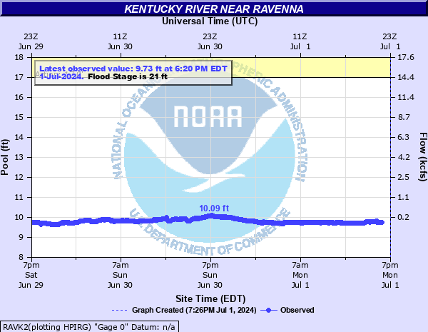
Kentucky River near Ravenna
Critical Stages
17' - Action
21' - Flood
25' - Moderate
31' - Major
Latest Observation
Updated: 5:20 PM EST 12/14/25
Status: No Flooding
Stage: 9.78 ft
Flow: 0.0568 kcfs
Forecast
Forecast not available for this location.
| Time | Stage (ft) | Flow (kcfs) |
|---|---|---|
| 5:20 PM 12/14 | 9.78 | 0.0568 |
| 5:15 PM 12/14 | 9.78 | 0.0568 |
| 5:10 PM 12/14 | 9.79 | 0.0608 |
| 5:05 PM 12/14 | 9.79 | 0.0608 |
| 5:00 PM 12/14 | 9.79 | 0.0608 |
| 4:55 PM 12/14 | 9.78 | 0.0568 |
| 4:50 PM 12/14 | 9.78 | 0.0568 |
| 4:45 PM 12/14 | 9.79 | 0.0608 |
| 4:40 PM 12/14 | 9.78 | 0.0568 |
| 4:35 PM 12/14 | 9.79 | 0.0608 |
| 4:30 PM 12/14 | 9.79 | 0.0608 |
| 4:25 PM 12/14 | 9.79 | 0.0608 |
| 4:20 PM 12/14 | 9.81 | 0.0681 |
| 4:15 PM 12/14 | 9.81 | 0.0681 |
| 4:10 PM 12/14 | 9.81 | 0.0681 |
| 4:05 PM 12/14 | 9.81 | 0.0681 |
| 4:00 PM 12/14 | 9.82 | 0.0714 |
| 3:55 PM 12/14 | 9.82 | 0.0714 |
| 3:50 PM 12/14 | 9.82 | 0.0714 |
| 3:45 PM 12/14 | 9.82 | 0.0714 |
| 3:40 PM 12/14 | 9.81 | 0.0681 |
| 3:35 PM 12/14 | 9.82 | 0.0714 |
| 3:30 PM 12/14 | 9.82 | 0.0714 |
| 3:25 PM 12/14 | 9.83 | 0.0749 |
| 3:20 PM 12/14 | 9.81 | 0.0681 |
| 3:15 PM 12/14 | 9.82 | 0.0714 |
| 3:10 PM 12/14 | 9.82 | 0.0714 |
| 3:05 PM 12/14 | 9.81 | 0.0681 |
| 3:00 PM 12/14 | 9.81 | 0.0681 |
| 2:55 PM 12/14 | 9.81 | 0.0681 |
39.36' -
Flooding will exceed the highest flood on record.
31' -
Major flooding occurs.
25' -
Moderate flooding occurs.
21.5' -
Sang Branch Road is under water at Red Lick Creek.
21' -
Low lying areas flood. Red Lick Road, Millers Creek Road, Dark Hollow Road, and Noland Creek Road flood in several places.
| Date | Stage (ft) |
|---|---|
| Mar 2, 2021 | 40.3 |
| Feb 4, 1939 | 39.37 |
| Mar 27, 1913 | 38.87 |
| Jan 31, 1957 | 38.37 |
| Mar 1, 1972 | 37.57 |
| Feb 9, 1978 | 37.57 |
| Jan 29, 1918 | 37.57 |
| Mar 24, 1929 | 37.27 |
| Feb 18, 2025 | 36.96 |
| Feb 18, 2003 | 35.02 |
| Apr 5, 2025 | 32.02 |
| Feb 25, 2019 | 31.73 |
| Mar 6, 2015 | 30.25 |
| Feb 7, 2004 | 30.15 |
| May 10, 2009 | 28.58 |
| May 4, 2010 | 28.39 |
| Jun 1, 2004 | 28.06 |
| Jan 24, 1937 | 27.47 |
| Apr 4, 2015 | 26.87 |
| Feb 22, 2019 | 25.73 |
Data provided by the National Weather Service.