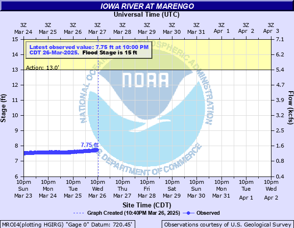
Iowa River at Marengo
Critical Stages
13' - Action
15' - Flood
17' - Moderate
19' - Major
Latest Observation
Updated: 2:00 PM CST 12/15/25
Status: No Flooding
Stage: 7.61 ft
Flow: 1.18 kcfs
Forecast
Forecast not available for this location.
| Time | Stage (ft) | Flow (kcfs) |
|---|---|---|
| 2:00 PM 12/15 | 7.61 | 1.18 |
| 1:45 PM 12/15 | 7.66 | 1.21 |
| 1:30 PM 12/15 | 7.59 | 1.17 |
| 1:15 PM 12/15 | 7.11 | 0.849 |
| 1:00 PM 12/15 | 7.15 | 0.876 |
| 12:45 PM 12/15 | 7.18 | 0.898 |
| 12:30 PM 12/15 | 7.23 | 0.933 |
| 12:15 PM 12/15 | 7.29 | 0.977 |
| 12:00 PM 12/15 | 7.44 | 1.08 |
| 11:45 AM 12/15 | 7.43 | 1.07 |
| 11:30 AM 12/15 | 7.46 | 1.09 |
| 11:15 AM 12/15 | 7.48 | 1.11 |
| 11:00 AM 12/15 | 7.46 | 1.09 |
| 10:45 AM 12/15 | 7.44 | 1.08 |
| 10:30 AM 12/15 | 7.4 | 1.06 |
| 10:15 AM 12/15 | 7.38 | 1.04 |
| 10:00 AM 12/15 | 7.39 | 1.05 |
| 9:45 AM 12/15 | 7.38 | 1.04 |
| 9:30 AM 12/15 | 7.38 | 1.04 |
| 9:15 AM 12/15 | 7.37 | 1.03 |
| 9:00 AM 12/15 | 7.36 | 1.03 |
| 8:45 AM 12/15 | 7.33 | 1.01 |
| 8:30 AM 12/15 | 7.27 | 0.963 |
| 8:15 AM 12/15 | 7.14 | 0.869 |
| 8:00 AM 12/15 | 7.09 | 0.835 |
| 7:45 AM 12/15 | 7.08 | 0.828 |
| 7:30 AM 12/15 | 7.26 | 0.955 |
| 7:15 AM 12/15 | 7.33 | 1.01 |
| 7:00 AM 12/15 | 7.36 | 1.03 |
| 6:45 AM 12/15 | 7.35 | 1.02 |
24.5' -
Water reaches the top of the levee at the invert at Highway V66.
23.7' -
Water reaches the top of the levee invert on the west side of Marengo.
22' -
Water approaches the top of the levee on the south bank at Marengo.
20.9' -
Water reaches the bottom of the Highway V66 bridge.
19.5' -
Water affects the Whirlpool Corporation parking lot and southeast exterior of the plant in Middle Amana.
19' -
Major Flood Stage. Homes west of Marengo are affected by floodwaters. Significant flooding of agricultural land.
18' -
Water breaches the mill race dikes near Middle Amana.
17' -
Moderate Flood Stage. Extensive inundation of agricultural land.
16' -
Water affects agricultural land along the river. Water is several feet deep in places.
15' -
Water reaches the bottom of the levee surrounding Marengo. Water affects low lying agricultural land along the river
14' -
Low lying agricultural land and pastureland along the river upstream of Marengo is affected.
11' -
Water affects the lowest agricultural land along the river.
| Date | Stage (ft) |
|---|---|
| Jun 12, 2008 | 21.38 |
| May 31, 2013 | 20.36 |
| Jul 19, 1993 | 20.31 |
| Jul 12, 1993 | 20.26 |
| Jul 2, 2014 | 19.96 |
| Jul 12, 1969 | 19.79 |
| Aug 19, 1993 | 19.57 |
| Mar 19, 1979 | 19.4 |
| Mar 31, 1960 | 19.21 |
| Sep 6, 2018 | 19.14 |
| Jun 30, 1998 | 18.92 |
| Mar 17, 2019 | 18.83 |
| May 19, 1974 | 18.82 |
| Mar 24, 1975 | 18.82 |
| Oct 10, 2018 | 18.76 |
| Mar 13, 1980 | 18.74 |
| Jun 21, 1990 | 18.68 |
| May 29, 2019 | 18.44 |
| Dec 18, 2015 | 18.31 |
| Feb 27, 1971 | 18.27 |
Data provided by the National Weather Service.