« Back to Hickory Hills Rivers
Wolf River above Gulfport
Critical Stages
7' - Action
8' - Flood
12' - Moderate
15' - Major
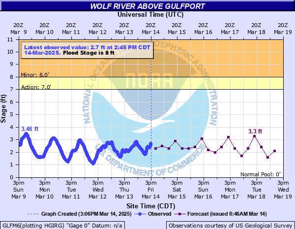
Latest Observation
Updated: 1:45 PM CST 12/15/25
Status: No Flooding
Stage: 1.97 ft
Flow: -999 kcfs
Forecast
| Time | Stage (ft) | Flow (kcfs) |
|---|---|---|
| 6 PM 12/15 | 2 | -999 |
| 12 AM 12/16 | 1.6 | -999 |
| 6 AM 12/16 | 0.3 | -999 |
| 12 PM 12/16 | 1.2 | -999 |
| 6 PM 12/16 | 2 | -999 |
| 12 AM 12/17 | 1.4 | -999 |
| 6 AM 12/17 | 0.3 | -999 |
| 12 PM 12/17 | 1.3 | -999 |
| 6 PM 12/17 | 2 | -999 |
| 12 AM 12/18 | 2.4 | -999 |
| 6 AM 12/18 | 0.6 | -999 |
| 12 PM 12/18 | 1.3 | -999 |
| 6 PM 12/18 | 2.1 | -999 |
| 12 AM 12/19 | 2.6 | -999 |
| 6 AM 12/19 | 0.9 | -999 |
| 12 PM 12/19 | 1.2 | -999 |
| 6 PM 12/19 | 2.3 | -999 |
| 12 AM 12/20 | 2.9 | -999 |
| 6 AM 12/20 | 1.3 | -999 |
| Time | Stage (ft) | Flow (kcfs) |
|---|---|---|
| 1:45 PM 12/15 | 1.97 | -999 |
| 1:30 PM 12/15 | 1.93 | -999 |
| 1:15 PM 12/15 | 1.89 | -999 |
| 1:00 PM 12/15 | 1.83 | -999 |
| 12:45 PM 12/15 | 1.78 | -999 |
| 12:30 PM 12/15 | 1.75 | -999 |
| 12:15 PM 12/15 | 1.72 | -999 |
| 12:00 PM 12/15 | 1.71 | -999 |
| 11:45 AM 12/15 | 1.71 | -999 |
| 11:30 AM 12/15 | 1.68 | -999 |
| 11:15 AM 12/15 | 1.63 | -999 |
| 11:00 AM 12/15 | 1.58 | -999 |
| 10:45 AM 12/15 | 1.5 | -999 |
| 10:30 AM 12/15 | 1.43 | -999 |
| 10:15 AM 12/15 | 1.37 | -999 |
| 10:00 AM 12/15 | 1.34 | -999 |
| 9:45 AM 12/15 | 1.29 | -999 |
| 9:30 AM 12/15 | 1.34 | -999 |
| 9:15 AM 12/15 | 1.36 | -999 |
| 9:00 AM 12/15 | 1.41 | -999 |
| 8:45 AM 12/15 | 1.45 | -999 |
| 8:30 AM 12/15 | 1.51 | -999 |
| 8:15 AM 12/15 | 1.58 | -999 |
| 8:00 AM 12/15 | 1.63 | -999 |
| 7:45 AM 12/15 | 1.66 | -999 |
| 7:30 AM 12/15 | 1.65 | -999 |
| 7:15 AM 12/15 | 1.61 | -999 |
| 7:00 AM 12/15 | 1.55 | -999 |
| 6:45 AM 12/15 | 1.48 | -999 |
| 6:30 AM 12/15 | 1.41 | -999 |
16.5' -
Flood of Record occurred on September 1, 2012. Major flooding will occur with homes and businesses along the river inundated. Sections of major roadways will be flooded, including MS Highway 1101/Menge Ave., Bells Ferry Rd., Red Creek Rd., and Freddie Frank Rd, among others.
15' -
Major flooding of the area will occur. Several homes on Magnolia Drive will be flooded along with business structures along Menge Avenue. The Menge Avenue bridge will be under water. Water will be in several homes along the river near the Bells Ferry Road bridge. Bells Ferry Road will be closed within a mile of the bridge as the road will be covered by swift moving river current.
12' -
Water will be in several homes along the river near the Bells Ferry Road bridge. Bells Ferry Road will be closed within a mile of the bridge as the road will be covered by swift moving river current.
10' -
Bells Ferry Road will be closed within a mile of the bridge as the road will be covered by swift moving river current.
9' -
Bells Ferry Road will be impassable with deep water on the east bridge approach.
8' -
Bells Ferry Road will begin to flood. There will be water over the access road just upstream of the bridge and the road will become impassable very quickly.
| Date | Stage (ft) |
|---|---|
| Sep 1, 2012 | 16.5 |
| May 10, 1995 | 15.39 |
| May 14, 2019 | 14.46 |
| Aug 31, 2021 | 12.56 |
| Jun 20, 2021 | 12.4 |
| Jan 23, 1993 | 12.3 |
| Sep 27, 2002 | 12.3 |
| Apr 16, 2021 | 11.8 |
| Apr 9, 1983 | 11.7 |
| Jun 22, 2017 | 11.06 |
| Jun 11, 2001 | 10.9 |
| Feb 10, 1981 | 10.64 |
| Mar 5, 2001 | 10.6 |
| May 15, 1990 | 10.5 |
| May 19, 1991 | 10.4 |
| Mar 26, 2021 | 10.12 |
| Apr 15, 2018 | 10.12 |
| Feb 4, 2022 | 10.11 |
| May 12, 2021 | 10.04 |
| Apr 16, 2015 | 10 |
Data provided by the National Weather Service.