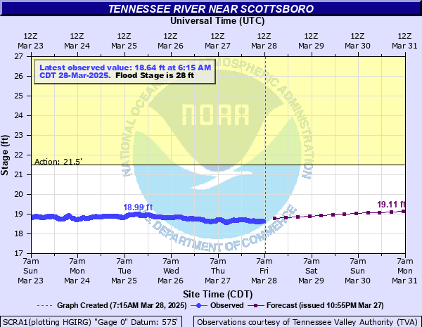
Tennessee River near Scottsboro
Critical Stages
21.5' - Action
28' - Flood
31' - Moderate
35' - Major
Latest Observation
Updated: 9:15 AM CST 12/14/25
Status: No Flooding
Stage: 18.56 ft
Flow: -999 kcfs
Forecast
| Time | Stage (ft) | Flow (kcfs) |
|---|---|---|
| 12 PM 12/14 | 18.59 | -999 |
| 6 PM 12/14 | 18.64 | -999 |
| 12 AM 12/15 | 18.69 | -999 |
| 6 AM 12/15 | 18.73 | -999 |
| 12 PM 12/15 | 18.77 | -999 |
| 6 PM 12/15 | 18.8 | -999 |
| 12 AM 12/16 | 18.84 | -999 |
| 6 AM 12/16 | 18.88 | -999 |
| 12 PM 12/16 | 18.92 | -999 |
| 6 PM 12/16 | 18.96 | -999 |
| 12 AM 12/17 | 19 | -999 |
| 6 AM 12/17 | 19.02 | -999 |
| 12 PM 12/17 | 19.03 | -999 |
| 6 PM 12/17 | 19.04 | -999 |
| 12 AM 12/18 | 19.05 | -999 |
| 6 AM 12/18 | 19.06 | -999 |
| 12 PM 12/18 | 19.06 | -999 |
| 6 PM 12/18 | 19.07 | -999 |
| 12 AM 12/19 | 19.08 | -999 |
| 6 AM 12/19 | 19.04 | -999 |
| 12 PM 12/19 | 19 | -999 |
| 6 PM 12/19 | 18.95 | -999 |
| 12 AM 12/20 | 18.91 | -999 |
| 6 AM 12/20 | 18.86 | -999 |
| 12 PM 12/20 | 18.83 | -999 |
| 6 PM 12/20 | 18.78 | -999 |
| 12 AM 12/21 | 18.74 | -999 |
| Time | Stage (ft) | Flow (kcfs) |
|---|---|---|
| 9:15 AM 12/14 | 18.56 | -999 |
| 9:00 AM 12/14 | 18.55 | -999 |
| 8:45 AM 12/14 | 18.55 | -999 |
| 8:30 AM 12/14 | 18.56 | -999 |
| 8:15 AM 12/14 | 18.55 | -999 |
| 8:00 AM 12/14 | 18.55 | -999 |
| 7:45 AM 12/14 | 18.55 | -999 |
| 7:30 AM 12/14 | 18.56 | -999 |
| 7:15 AM 12/14 | 18.57 | -999 |
| 7:00 AM 12/14 | 18.57 | -999 |
| 6:45 AM 12/14 | 18.56 | -999 |
| 6:30 AM 12/14 | 18.55 | -999 |
| 6:15 AM 12/14 | 18.54 | -999 |
| 6:00 AM 12/14 | 18.54 | -999 |
| 5:45 AM 12/14 | 18.54 | -999 |
| 5:30 AM 12/14 | 18.53 | -999 |
| 5:15 AM 12/14 | 18.53 | -999 |
| 5:00 AM 12/14 | 18.53 | -999 |
| 4:45 AM 12/14 | 18.53 | -999 |
| 4:30 AM 12/14 | 18.52 | -999 |
| 4:15 AM 12/14 | 18.52 | -999 |
| 4:00 AM 12/14 | 18.52 | -999 |
| 3:45 AM 12/14 | 18.52 | -999 |
| 3:30 AM 12/14 | 18.51 | -999 |
| 3:15 AM 12/14 | 18.51 | -999 |
| 3:00 AM 12/14 | 18.51 | -999 |
| 2:45 AM 12/14 | 18.52 | -999 |
| 2:30 AM 12/14 | 18.52 | -999 |
| 2:15 AM 12/14 | 18.53 | -999 |
| 2:00 AM 12/14 | 18.53 | -999 |
35' -
Major flooding is occurring on the south side of Scottsboro...with numerous roads and buildings flooded.
31' -
Portions of Highway 35 between Highway 72 and the river are likely underwater...along with dwellings and low lying areas near the river. Backwater is likely causing significant flooding near tributaries...including on the south side of Scottsboro.
28' -
Dwellings near Lake Guntersville begin to flood...and an old mill on the right bank also floods. Backwater may be causing high water to approach structures southeast of Scottsboro. Water begins to approach lodges at Camp Jackson.
23' -
The river begins to flood the road to Camp Jackson near the park entrance. Most of the camp is not affected at this stage.
21.5' -
Boathouses near the river begin to flood...but little or no damage occurs.
| Date | Stage (ft) |
|---|---|
| Feb 24, 2019 | 22.91 |
| Dec 26, 2015 | 22.9 |
| Feb 14, 2020 | 22.52 |
Data provided by the National Weather Service.