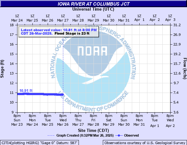
Iowa River at Columbus Jct
Critical Stages
19' - Action
23' - Flood
25' - Moderate
26.5' - Major
Latest Observation
Updated: 5:00 PM CST 12/15/25
Status: No Flooding
Stage: 10.68 ft
Flow: 5.35 kcfs
Forecast
Forecast not available for this location.
| Time | Stage (ft) | Flow (kcfs) |
|---|---|---|
| 5:00 PM 12/15 | 10.68 | 5.35 |
| 4:45 PM 12/15 | 10.68 | 5.35 |
| 4:30 PM 12/15 | 10.68 | 5.35 |
| 4:15 PM 12/15 | 10.68 | 5.35 |
| 4:00 PM 12/15 | 10.68 | 5.35 |
| 3:45 PM 12/15 | 10.68 | 5.35 |
| 3:30 PM 12/15 | 10.68 | 5.35 |
| 3:15 PM 12/15 | 10.68 | 5.35 |
| 3:00 PM 12/15 | 10.68 | 5.35 |
| 2:45 PM 12/15 | 10.68 | 5.35 |
| 2:30 PM 12/15 | 10.69 | 5.37 |
| 2:15 PM 12/15 | 10.7 | 5.39 |
| 2:00 PM 12/15 | 10.71 | 5.42 |
| 1:45 PM 12/15 | 10.73 | 5.46 |
| 1:30 PM 12/15 | 10.77 | 5.54 |
| 1:15 PM 12/15 | 10.84 | 5.69 |
| 1:00 PM 12/15 | -9999 | -999 |
| 12:45 PM 12/15 | -9999 | -999 |
| 12:30 PM 12/15 | -9999 | -999 |
| 12:15 PM 12/15 | -9999 | -999 |
| 12:00 PM 12/15 | -9999 | -999 |
| 11:45 AM 12/15 | -9999 | -999 |
| 11:30 AM 12/15 | -9999 | -999 |
| 11:15 AM 12/15 | -9999 | -999 |
| 11:00 AM 12/15 | -9999 | -999 |
| 10:45 AM 12/15 | -9999 | -999 |
| 10:30 AM 12/15 | -9999 | -999 |
| 10:15 AM 12/15 | -9999 | -999 |
| 10:00 AM 12/15 | -9999 | -999 |
| 9:45 AM 12/15 | -9999 | -999 |
36' -
Water goes over the Iowa State Highway 92 bridge roadway.
31.8' -
Water reaches the lowest portion of the midspan of the Iowa State Highway 92 bridge.
31.3' -
Water reaches the lowest portion of the west abutment of the Iowa State Highway 92 bridge.
31' -
Water is over the west approach to the Iowa State Highway 92 bridge. Water also reaches the lowest portion of the east abutment of the Iowa State Highway 92 bridge.
27.2' -
Water goes over Iowa State Highway 92.
26.8' -
Water begins rising onto Iowa State Highway 92.
26.5' -
Major Flood Stage. Water goes over U.S. Highway 61 downstream of Columbus Junction.
25.1' -
Water reaches the old railroad bridge on the south side of the Fairgrounds.
25' -
Moderate Flood Stage. Intersection of Highway G36 and 165th St is underwater and closed.
23' -
Flood Stage. Water affects residential property along the river south of the Iowa Highway 92 Bridge. Locust St is closed at the bridge over Monkey Run.
| Date | Stage (ft) |
|---|---|
| Jun 15, 2008 | 32.3 |
| Jul 7, 1993 | 28.3 |
| Jul 3, 2014 | 27.67 |
| Apr 19, 2013 | 25.82 |
| Sep 30, 2016 | 25.29 |
| May 31, 2019 | 24.95 |
| Oct 1, 2016 | 24.8 |
| Oct 9, 2018 | 24.32 |
| May 30, 2004 | 24.28 |
| Mar 21, 2019 | 24.21 |
| Sep 8, 2018 | 23.91 |
| Feb 23, 1997 | 23.5 |
| May 12, 1996 | 23.5 |
| Feb 19, 2011 | 19.38 |
| Jun 17, 2015 | 19.08 |
Data provided by the National Weather Service.