Big Sioux River at Akron
Critical Stages
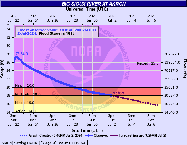
14' - Action
16' - Flood
18' - Moderate
20' - Major
Latest Observation
Updated: 3:00 AM CST 12/16/25
Status: No Flooding
Stage: 5.73 ft
Flow: 0.988 kcfs
Forecast
Forecast not available for this location.
| Time | Stage (ft) | Flow (kcfs) |
|---|---|---|
| 3:00 AM 12/16 | 5.73 | 0.988 |
| 2:45 AM 12/16 | 5.74 | 0.992 |
| 2:30 AM 12/16 | 5.74 | 0.992 |
| 2:15 AM 12/16 | 5.74 | 0.992 |
| 2:00 AM 12/16 | 5.74 | 0.992 |
| 1:45 AM 12/16 | 5.75 | 0.995 |
| 1:30 AM 12/16 | 5.76 | 0.999 |
| 1:15 AM 12/16 | 5.77 | 1 |
| 1:00 AM 12/16 | 5.77 | 1 |
| 12:45 AM 12/16 | 5.77 | 1 |
| 12:30 AM 12/16 | 5.79 | 1.01 |
| 12:15 AM 12/16 | 5.79 | 1.01 |
| 12:00 AM 12/16 | 5.79 | 1.01 |
| 11:45 PM 12/15 | 5.79 | 1.01 |
| 11:30 PM 12/15 | 5.79 | 1.01 |
| 11:15 PM 12/15 | 5.8 | 1.01 |
| 11:00 PM 12/15 | 5.8 | 1.01 |
| 10:45 PM 12/15 | 5.81 | 1.02 |
| 10:30 PM 12/15 | 5.81 | 1.02 |
| 10:15 PM 12/15 | 5.81 | 1.02 |
| 10:00 PM 12/15 | 5.82 | 1.02 |
| 9:45 PM 12/15 | 5.82 | 1.02 |
| 9:30 PM 12/15 | 5.82 | 1.02 |
| 9:15 PM 12/15 | 5.82 | 1.02 |
| 9:00 PM 12/15 | 5.82 | 1.02 |
| 8:45 PM 12/15 | 5.82 | 1.02 |
| 8:30 PM 12/15 | 5.81 | 1.02 |
| 8:15 PM 12/15 | 5.8 | 1.01 |
| 8:00 PM 12/15 | 5.79 | 1.01 |
| 7:45 PM 12/15 | 5.77 | 1 |
26' -
The western portions of Akron will be flooded with water reaching as far as the the city park and baseball field to the downtown area.
25' -
Much of Highway 48 east of the bridge is flooded and the remaining levees in Akron are overtopped.
23.25' -
Levee gates at Riverside in Sioux City will be closed.
23' -
Water begins to enter the northwest portions of Akron, potentially flooding a couple of structures near the intersection of Hwy 48 and Hwy 12. Highway 50 near Westfield will be flooded, and the bridge east of Jefferson will be overtopped.
22' -
The lower portions of the railroad tracks in Akron begin to flood.
20' -
Highway 48/Big Sioux River Rd just west of Akron begins to flood as does the parking lot at the boat ramp in Akron begins to flood.
19.5' -
Several farm houses are flooded.
17' -
About 6500 acres of farm land are flooded.
16' -
Several farm levees are overtopped with significant flooding of agricultural lands.
15' -
Some rural roads on the South Dakota side of the river begin to flood.
12' -
Some very minor flooding of the lowest lying areas along the river begins.
| Date | Stage (ft) |
|---|---|
| Jun 22, 2024 | 27.35 |
| Jun 18, 2014 | 25.46 |
| Mar 16, 2019 | 23.94 |
| Jun 23, 2018 | 23.45 |
| Apr 26, 2001 | 23.38 |
| May 10, 1993 | 23.05 |
| Apr 9, 1969 | 22.99 |
| Sep 27, 2010 | 22.88 |
| Apr 9, 1997 | 22.64 |
| Apr 10, 2006 | 22.32 |
| Jun 23, 1984 | 22.27 |
| Mar 31, 1962 | 22.08 |
| Sep 25, 1986 | 21.98 |
| Mar 16, 2007 | 21.76 |
| Mar 25, 1979 | 21.74 |
| Apr 1, 1960 | 21.58 |
| Jun 22, 1983 | 21.49 |
| Jun 16, 1994 | 21.08 |
| Apr 22, 1995 | 20.88 |
| Apr 8, 1965 | 20.85 |
Data provided by the National Weather Service.