« Back to Iao Valley State Park Rivers
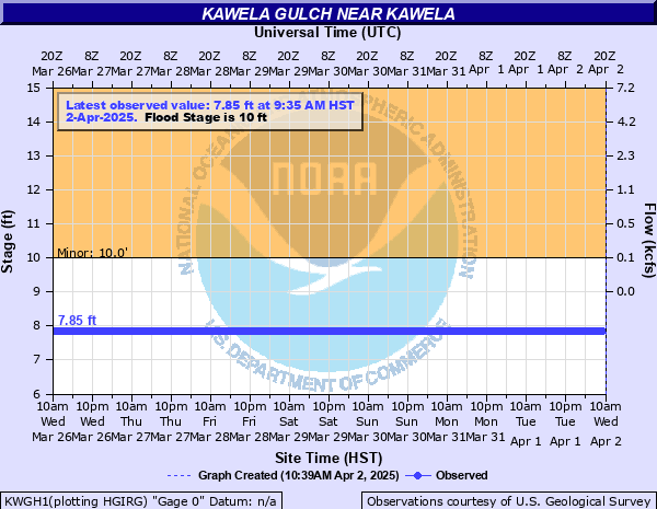
Kawela Gulch near Kawela
Critical Stages
Action
10' - Flood
Moderate
Major
Latest Observation
Updated: 8:35 PM HST 12/14/25
Status: No Flooding
Stage: 7.85 ft
Flow: -999 kcfs
Forecast
Forecast not available for this location.
| Time | Stage (ft) | Flow (kcfs) |
|---|---|---|
| 9:35 PM 12/14 | 7.85 | -999 |
| 9:30 PM 12/14 | 7.85 | -999 |
| 9:25 PM 12/14 | 7.85 | -999 |
| 9:20 PM 12/14 | 7.85 | -999 |
| 9:15 PM 12/14 | 7.85 | -999 |
| 9:10 PM 12/14 | 7.85 | -999 |
| 9:05 PM 12/14 | 7.85 | -999 |
| 9:00 PM 12/14 | 7.85 | -999 |
| 8:55 PM 12/14 | 7.85 | -999 |
| 8:50 PM 12/14 | 7.85 | -999 |
| 8:45 PM 12/14 | 7.85 | -999 |
| 8:40 PM 12/14 | 7.85 | -999 |
| 8:35 PM 12/14 | 7.85 | -999 |
| 8:30 PM 12/14 | 7.85 | -999 |
| 8:25 PM 12/14 | 7.85 | -999 |
| 8:20 PM 12/14 | 7.85 | -999 |
| 8:15 PM 12/14 | 7.85 | -999 |
| 8:10 PM 12/14 | 7.85 | -999 |
| 8:05 PM 12/14 | 7.85 | -999 |
| 8:00 PM 12/14 | 7.85 | -999 |
| 7:55 PM 12/14 | 7.85 | -999 |
| 7:50 PM 12/14 | 7.85 | -999 |
| 7:45 PM 12/14 | 7.85 | -999 |
| 7:40 PM 12/14 | 7.85 | -999 |
| 7:35 PM 12/14 | 7.85 | -999 |
| 7:30 PM 12/14 | 7.85 | -999 |
| 7:25 PM 12/14 | 7.85 | -999 |
| 7:20 PM 12/14 | 7.85 | -999 |
| 7:15 PM 12/14 | 7.85 | -999 |
| 7:10 PM 12/14 | 7.85 | -999 |
10' -
Kamehameha V Hwy (Hwy 450) closes at the Wawaia Gulch Ford ("Kamalo Dip") between mile markers 10 and 11.
Historical crest information is not available.
Data provided by the National Weather Service.