« Back to Iao Valley State Park Rivers
West Wailuaiki Stream near Hana
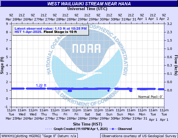
Critical Stages
Action
10' - Flood
Moderate
13.5' - Major
Latest Observation
Updated: 10:25 PM HST 12/14/25
Status: No Flooding
Stage: 1.13 ft
Flow: 0.0033 kcfs
Forecast
Forecast not available for this location.
| Time | Stage (ft) | Flow (kcfs) |
|---|---|---|
| 10:25 PM 12/14 | 1.13 | 0.0033 |
| 10:20 PM 12/14 | 1.13 | 0.0033 |
| 10:15 PM 12/14 | 1.13 | 0.0033 |
| 10:10 PM 12/14 | 1.13 | 0.0033 |
| 10:05 PM 12/14 | 1.13 | 0.0033 |
| 10:00 PM 12/14 | 1.13 | 0.0033 |
| 9:55 PM 12/14 | 1.13 | 0.0033 |
| 9:50 PM 12/14 | 1.13 | 0.0033 |
| 9:45 PM 12/14 | 1.13 | 0.0033 |
| 9:40 PM 12/14 | 1.13 | 0.0033 |
| 9:35 PM 12/14 | 1.13 | 0.0033 |
| 9:30 PM 12/14 | 1.13 | 0.0033 |
| 9:25 PM 12/14 | 1.13 | 0.0033 |
| 9:20 PM 12/14 | 1.13 | 0.0033 |
| 9:15 PM 12/14 | 1.13 | 0.0033 |
| 9:10 PM 12/14 | 1.13 | 0.0033 |
| 9:05 PM 12/14 | 1.13 | 0.0033 |
| 9:00 PM 12/14 | 1.13 | 0.0033 |
| 8:55 PM 12/14 | 1.13 | 0.0033 |
| 8:50 PM 12/14 | 1.13 | 0.0033 |
| 8:45 PM 12/14 | 1.13 | 0.0033 |
| 8:40 PM 12/14 | 1.13 | 0.0033 |
| 8:35 PM 12/14 | 1.14 | 0.0034 |
| 8:30 PM 12/14 | 1.13 | 0.0033 |
| 8:25 PM 12/14 | 1.14 | 0.0034 |
| 8:20 PM 12/14 | 1.14 | 0.0034 |
| 8:15 PM 12/14 | 1.14 | 0.0034 |
| 8:10 PM 12/14 | 1.14 | 0.0034 |
| 8:05 PM 12/14 | 1.14 | 0.0034 |
| 8:00 PM 12/14 | 1.14 | 0.0034 |
10' -
Indirect indicator of possible flooding along the Hana Hwy from Keanae to Nahiku.
Historical crest information is not available.
Data provided by the National Weather Service.